 Charlottetown
Canada could be heading into a longer, milder fall as an exceptionally strong El Niño reshapes weather patterns through September, October and November.
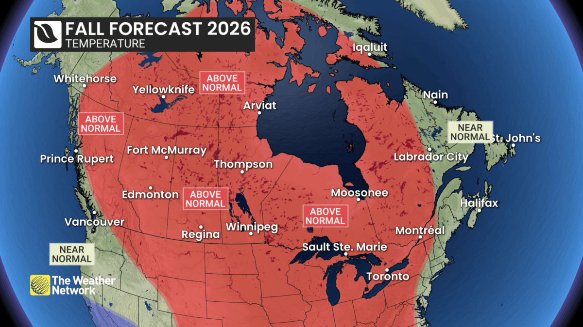
Credit: The Weather Network
The Weather Network says the event is projected to become the strongest El Niño on record, but that does not automatically mean Canada will see unprecedented weather. Instead, many regions may experience fewer classic fall storms, fewer Atlantic hurricanes and a delayed arrival of sustained winter conditions.
“Canada is not expected to feel the brunt of its effects,” said Doug Gillham, Senior Meteorologist at The Weather Network, adding that El Niño may actually moderate some seasonal extremes.
What El Niño means this fall
El Niño begins with unusually warm ocean temperatures in the tropical Pacific west of South America, which can alter the global jet stream.
This year’s event is unusually strong, adding uncertainty to the outlook. Forecasts point to the dominant pattern, but surprises remain possible. High-impact storms can still occur even if the overall season turns milder and quieter across Canada.
British Columbia
British Columbia should see a warmer, drier stretch through much of the second half of September and into October, particularly in the Interior.
Coastal areas are expected to stay closer to seasonal temperatures, while a more active Pacific storm pattern later in fall could push precipitation nearer normal.
Winter should arrive late for much of the province. Alpine areas are the exception, where temperatures could become cold enough for substantial early-season snow as ski season approaches, offering cautious optimism overall.
- Temperature Outlook: Above normal; Near normal coast
- Precipitation Outlook: Near normal west; Below normal interior
The Prairies
Across the Prairies, warmer-than-normal weather is expected to dominate, although early winter-like interruptions remain possible. Alberta may benefit from a longer harvest window after stormy summer weather caused delays, with precipitation leaning below normal.
Saskatchewan and Manitoba should also stay warmer than normal, with drier conditions favoured outside southern areas. Southern Saskatchewan and southern Manitoba could finish closer to normal precipitation.
Even when snow or hard freezes arrive early, milder conditions are expected to return through November and into December.
- Alberta
-
- Temperature Outlook: Above normal
- Precipitation Outlook: Below normal
-
- Saskatchewan
-
- Temperature Outlook: Above normal
- Precipitation Outlook: Near normal south; Below normal elsewhere
-
- Manitoba
-
- Temperature Outlook: Above normal
- Precipitation Outlook: Near normal south; Below normal elsewhere
-
Ontario and Quebec
Ontario and Quebec are in line for an extended fall, with September and October bringing the usual swings between mild and chilly weather. A stronger warmth signal is expected by November and into December, delaying sustained winter conditions.
Ontario could see fewer classic fall storms, though one major system could still define the season.
Quebec is expected to turn milder later in fall, with below-normal precipitation across much of the province. The slower arrival of cold may complicate ski-season snowmaking.
- Ontario
-
- Temperature Outlook: Above normal
- Precipitation Outlook: Below normal
-
- Quebec
-
- Temperature Outlook: Above normal west and central; Near normal east
- Precipitation Outlook:Below normal
-
Atlantic Canada
Atlantic Canada should see a typical fall overall, with changeable temperatures and precipitation near normal. The Atlantic hurricane season has been quiet through early September, but very warm nearby ocean waters mean tropical risks have not disappeared.
Late-season systems developing closer to North America remain a wildcard. Cooler spells may be more noticeable early in the season, while moisture from the southern U.S. storm track could occasionally reach the region. Consistent winter weather is expected to arrive later than usual.
- Temperature Outlook: Near normal; Above normal south
- Precipitation Outlook: Near normal
Northern Canada
Most of northern Canada is expected to run warmer than normal this fall, although western Yukon should stay closer to seasonal temperatures. Southern parts of the Northwest Territories and Nunavut may see below-normal precipitation, while far northern areas could receive above-normal amounts.
The warmth comes with an important caveat because average temperatures naturally fall quickly through the season. Hudson Bay freeze-up is expected to be delayed again, while Arctic sea ice should remain below normal, driven by long-term climate warming.
- Temperature Outlook: Above normal; Near normal western Yukon and northeastern Nunavut
- Precipitation Outlook: Below normal southern NWT and southern Nunavut; Above normal far north; Near normal elsewhere

pt_view id=”501a5966p2″ limit=8]