Banff

Alberta’s first widespread snowfall of the season is moving closer, and Environment Canada has issued yellow snowfall warnings for parts of the province ahead of the Thanksgiving long weekend.
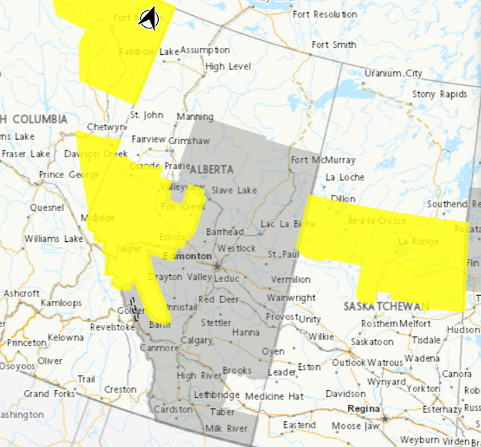
The warnings mark a significant change from Thursday’s forecast, when much of Alberta was covered by special weather statements. Snowfall amounts of 7 to 25 centimetres are now forecast in the warned areas of west-central and northwestern Alberta, with the heaviest accumulation expected over higher terrain.
Rain will turn to snow across west-central Alberta on Friday, October 9, as temperatures drop. Accumulating snow will initially be concentrated at higher elevations before spreading into lower areas Friday evening.
Where Will the Heaviest Snow Fall?
Environment Canada’s yellow snowfall warnings cover parts of western and northwestern Alberta, including areas around Grande Prairie, Hinton, Edson and Nordegg.
Snowfall amounts will vary considerably depending on elevation.
The greatest accumulation, approaching 25 cm, is expected along higher terrain and northeast-facing slopes, particularly Highway 40 between Grande Prairie and Hinton.
Communities in sheltered valleys and lower elevations, including Jasper, Grande Prairie and Valleyview, are expected to receive amounts closer to 7 cm.
Environment Canada warns that visibility could deteriorate during periods of heavier snow. Travel could become difficult, and localized power outages are possible.
What About Calgary, Edmonton and Red Deer?
Calgary, Edmonton and Red Deer remain under special weather statements rather than yellow snowfall warnings.
Environment Canada expects snow to accumulate across much of central and northern Alberta by Saturday, October 10, although amounts outside the warning areas remain uncertain.
In Edmonton, rain is expected to change to wet snow overnight, with approximately 2 cm forecast Saturday and additional snow possible Saturday night.
Calgary is currently expected to receive only light snow. However, heavier snowfall remains possible along the southern Alberta foothills.
The special weather statements also highlight areas south of Calgary, including the Cypress Hills near the Saskatchewan border, where more significant snowfall could develop.
When Will the Snow End?
The storm will move southward through Saturday night, bringing snow into southern Alberta on Sunday, October 11.
Snowfall in western and northern Alberta should gradually taper off from north to south Saturday and Saturday night, while areas farther south could continue seeing snow Sunday.
The timing means drivers heading out for Thanksgiving gatherings or returning from weekend trips could encounter rapidly changing road conditions.
Snow and Heavy Rain Also Expected in Other Western Provinces
The unsettled Thanksgiving weather extends beyond Alberta. Environment Canada has issued yellow snowfall warnings in northern British Columbia, where 15 to 25 cm of snow is expected around Stone Mountain Provincial Park, Tetsa River and sections of Highway 97, while the South Peace River region could receive 10 to 15 cm.
In northern Manitoba, special weather statements indicate a possibility of 10 to 25 cm of heavy, wet snow if temperatures turn colder than expected, although rain followed by lighter snowfall remains the more likely scenario.
Meanwhile, yellow rainfall warnings in northern Saskatchewan call for 40 to 60 mm of rain through Saturday, with precipitation potentially changing to snow Saturday night.
With Thanksgiving weekend travel underway, drivers should check current highway conditions and follow the latest warnings and forecasts through Environment and Climate Change Canada’s official weather alert map.