Environment and Climate Change Canada, recognizing the increasing severity of weather due to climate change, has completed a comprehensive eight-year radar modernization initiative, significantly enhancing its weather prediction capabilities.
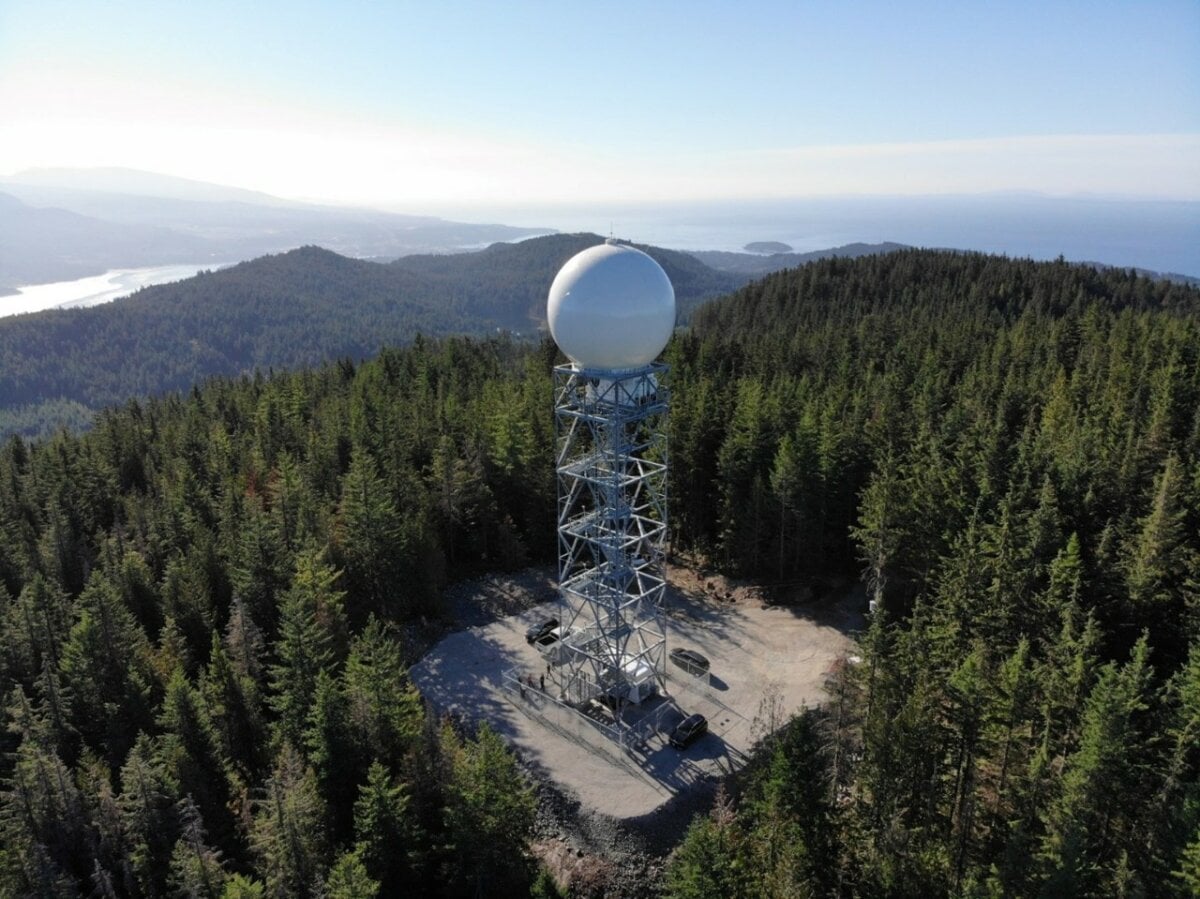
Halfmoon Peak radar in British Columbia, the final new radar installed in the network./Credit: Environment and Climate Change Canada
This initiative involved a $180.4 million investment to upgrade Canada’s weather radar network.
A total of 33 radars, including 32 state-of-the-art weather radars and one training radar, have been installed across the country, ensuring comprehensive coverage and advanced weather detection technologies.
“With the changing climate, it is essential to provide our meteorologists with the technology needed to issue the fastest and most accurate weather forecasts,” said Steven Guilbeault, Minister of Environment and Climate Change in a news release.
“This reliable, modern network of weather radars will give Canadians more lead time to take appropriate actions to protect themselves, their family, and their property from the effects of severe weather.”
These modern radars, deployed in strategic locations including King City, Ontario, and the Lower Athabasca region in Alberta, extend the traditional radar range from 250 to 330 kilometres, covering over four million square kilometres.
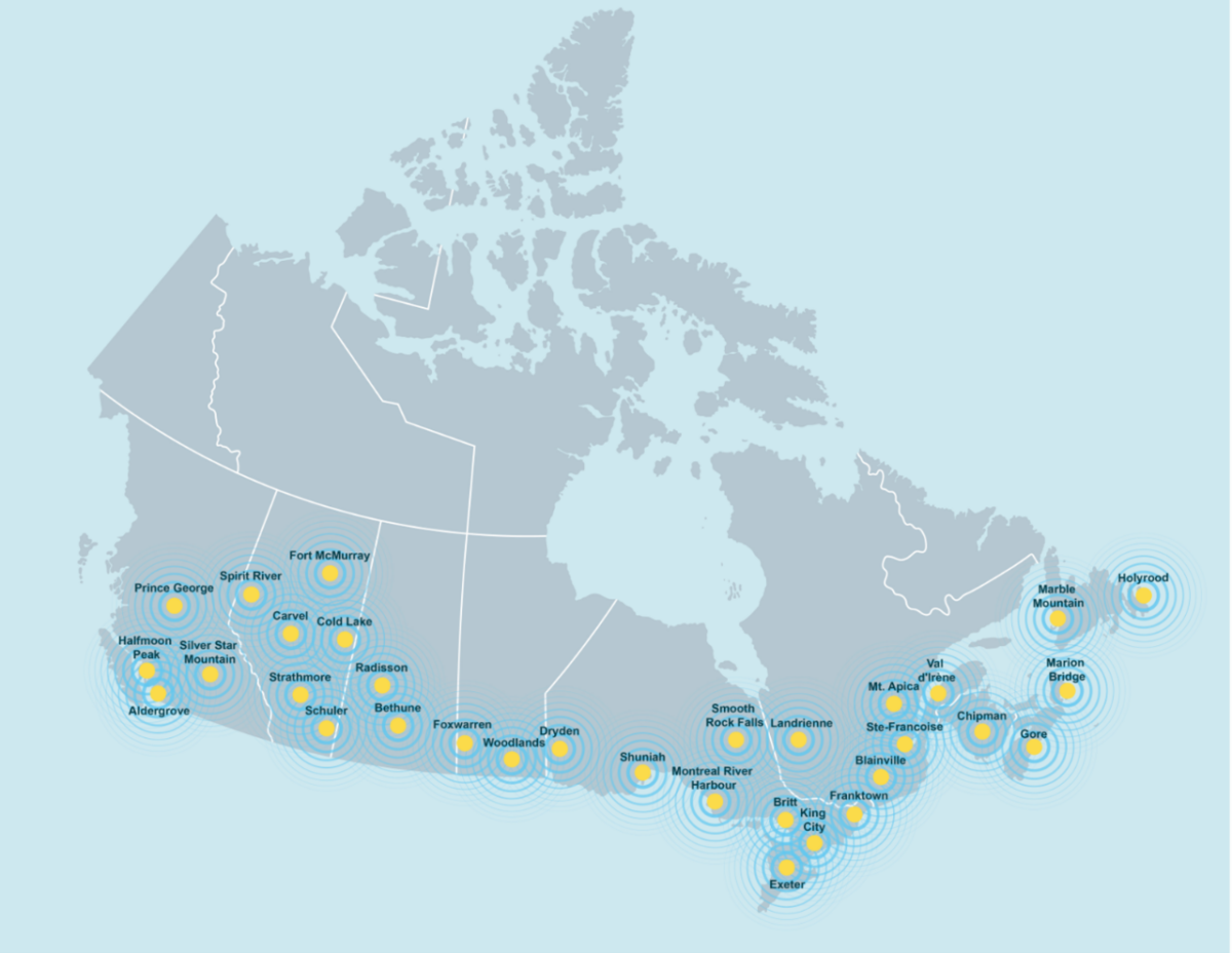
Per the news release, this upgrade ensures that 99 percent of Canadians are within 330 kilometres of a radar site, offering unparalleled accuracy in weather forecasting and severe weather detection. The King City radar, for example, enhances severe weather prediction capabilities for the Greater Toronto Area.
Radar Locations:
- Halfmoon Peak (Sunshine Coast)
- Aldergrove (near Vancouver)
- Prince George
- Silver Star Mountain (near Vernon)
- Bethune (near Regina)
- Carvel (near Edmonton)
- Foxwarren (near Brandon)
- Cold Lake
- Radisson (near Saskatoon)
- Schuler (near Medicine Hat)
- Spirit River (near Grande Prairie)
- Fort McMurray
- Strathmore (near Calgary)
- Woodlands (near Winnipeg)
- Britt (near Sudbury)
- Dryden
- Exeter (near London)
- Franktown (near Ottawa)
- King City (near Toronto)
- Montreal River (near Sault Ste. Marie)
- Smooth Rock Falls (near Timmins)
- Shuniah (near Thunder Bay)
- Mont Apica (near Saguenay)
- Landrienne (near Rouyn-Noranda)
- Blainville (near Montréal)
- Val-d’Irène (near Mont-Joli)
- Sainte-Françoise (near Trois-Rivières)
- Chipman (near Fredericton)
- Gore (near Halifax)
- Marion Bridge (near Sydney)
- Holyrood (near St. John’s)
- Marble Mountain (near Corner Brook)
Environment and Climate Change Canada says the enhanced network provides updates every six minutes, improving upon the previous 10-minute cycle. This improvement allows for quicker, more accurate forecasts and severe weather warnings, critical for emergency preparedness and response. The radars utilize dual-polarization technology, enabling meteorologists to differentiate between types of precipitation and even detect non-meteorological objects, improving the accuracy of severe weather event predictions.
The project supports Canada’s National Adaptation Strategy by contributing to a proactive approach to climate change, emphasizing the importance of early action to mitigate risks.


