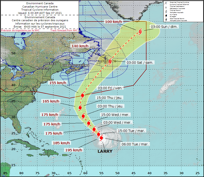
Hurricane Larry, currently at maximum sustained winds of 195 kilometres per hour, could reach Newfoundland this Friday, says Canadian Hurricane Centre in a statement issued today morning.
Canadian Hurricane Centre
The category-3 hurricane which is near Bermuda today is predicted to arrive along the Atlantic coast of Nova Scotia and southern Newfoundland Thursday. The current models suggest that the hurricane making a transition to a post-tropical storm while travelling very quickly across the Avalon Peninsula while some weather models predict it to track offshore.
The Canadian Hurricane Centre says though it is too early to predict the intensity of rainfall, a trough of low pressure that is approaching from the west can cause the hurricane to re-intensify while making the transition to post-tropical in a manner such as Igor in 2010.
Large ocean waves stirred up by the category-3 hurricane will arrive along the Atlantic coast of Nova Scotia and southern Newfoundland Thursday and the Grand Banks Marine district is on the windiest side of the storm.
The CHC continues to monitor Hurricane #Larry 🌀. Latest information indicates it is now likely to impact eastern Newfoundland this Friday. An update of this change will appear by 7 am NDT here: https://t.co/R5Yddzgvyj #nlwx #nlstorm pic.twitter.com/GlPR0lQs3X
— ECCC Canadian Hurricane Centre (@ECCC_CHC) September 7, 2021