Fall Temperature Map (CNW Group/The Weather Network)
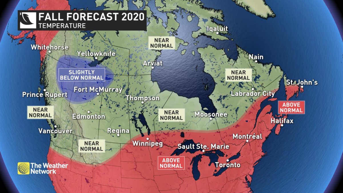
The Weather Network says most Canadians can expect near or above normal temperatures during 2020 fall, but parts of northern B.C. and Alberta are at risk of tipping to the cold side of normal. Once winter does settle in, the focus of winter’s fury is expected to be across Western Canada. Meanwhile Eastern Canada should see less severe cold than normal.
Chris Scott, Chief Meteorologist at The Weather Network said, “October and November will feature extended periods of ideal fall weather across most of Canada, and we expect that the arrival of consistent winter weather will be delayed.”
British Columbia
After a very warm and dry start to September, a pattern change will bring cooler and much wetter weather for October and November with the potential for an early start to the ski season. The winter is expected to be colder and snowier than normal across the province.
Temperature Outlook: Near normal, Below normal northeast
Precipitation Outlook: Above normal south and central; Near normal north
The Prairies
After a shot of October-like temperatures during early September, Weather Network expects extended periods of mild weather for October and November. Though the arrival of consistent cold looks to be delayed, the threat of quick shots of early winter weather exists, especially across Alberta. A colder than normal winter is expected for much of the region.
Alberta
Temperature Outlook: Near normal; Below normal north
Precipitation Outlook: Near normal, Above normal south and along the Rockies
Saskatchewan
Temperature Outlook: Near normal, Above normal southeast corner
Precipitation Outlook: Near normal, Above normal southwest corner
Manitoba
Temperature Outlook: Near normal; Above normal south
Precipitation Outlook: Near normal
Ontario & Quebec
Weather Network expects extended periods of pleasant fall weather through October and November, along with a delayed start to consistent winter weather. With above-normal temperatures expected for the winter season, the agency says less severe cold is expected, but an abundance of messy wintry weather can still readily occur with a milder pattern.
Ontario
Temperature Outlook: Above Normal; Near normal far north
Precipitation Outlook: Near normal
Québec
Temperature Outlook: Above normal, Near normal north
Precipitation Outlook: Near normal, Above normal east
Atlantic Canada
Weather Network says that the arrival of consistent winter weather will be delayed and above normal temperatures are expected for the fall season. While quick shots of cold weather are still likely, Near normal precipitation is expected for much of the region, but there is a heightened risk for tropical systems impacting the region. This could result in parts of the area being wetter than normal. Above normal temperatures are expected this winter which will likely mean a higher risk for storms that bring a combination of rain, ice and snow.
Temperature Outlook: Above normal; Near normal Labrador and northern Newfoundland
Precipitation Outlook: Near normal south, Above normal north
Northern Canada
According to Weather Network, colder than normal temperatures are expected across southern parts of the NWT and into southeastern Yukon. Above normal temperatures could extend into western parts of the Yukon and most areas will see near-normal precipitation.
Precipitation Outlook: Near normal, Below normal southern NWT and southeast Yukon, Above normal western Yukon
Precipitation Outlook: Near normal