After last year’s record-breaking warm winter, Canadians should brace for a more typical cold season ahead. The Weather Network has released its forecast for December through February, indicating that winter conditions will make a significant comeback.

Winter forecast 2024-2025 /Credit: The Weather Network
Meteorologists anticipate a more traditional Canadian winter, marked by regional extremes and a mix of cold temperatures, snowfall, and milder conditions.
“Canada got off exceptionally easy last winter with much warmer-than-normal temperatures from coast to coast. However, we do not expect a repeat performance from winter this year,” said Chris Scott, Chief Meteorologist at The Weather Network. He attributed last year’s mild weather to a strong El Niño event, which is no longer influencing the climate. “We expect that winter will show up this year and attempt to redeem its reputation,” Scott added.
According to the Weather Network, Western Canada, particularly British Columbia and Alberta, will experience colder-than-normal temperatures and above-normal snowfall, benefiting ski seasons.
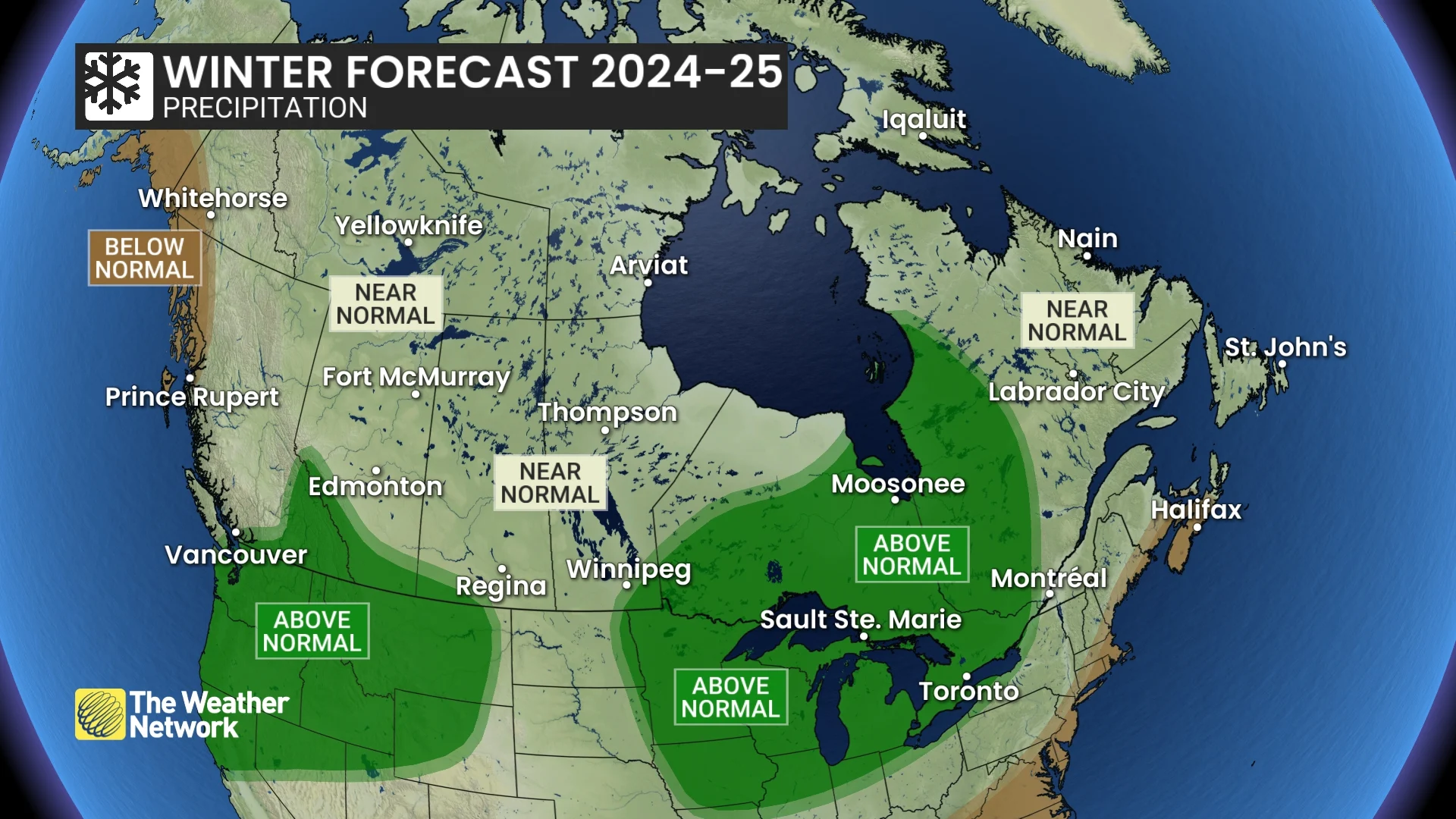
Central Canada will feel winter’s effects mainly in December but can expect milder temperatures and below-normal snow totals overall.
Atlantic Canada is predicted to have a mild winter with fewer nor’easters and less consistent snow cover due to milder spells and rain.
Northern Canada will see varied temperatures, with colder conditions in the Yukon and milder weather in the east.
Winter forecast 2024-2025 /Credit: The Weather Network
British Columbia
British Columbia is set to face a colder winter with extended periods of severe cold, including arctic outflow events affecting the south coast.
Southern regions like Vancouver, Victoria, and Kelowna can anticipate above-average snowfall due to an active storm track. This is promising news for ski enthusiasts, as a solid ski season is expected with a strong start compared to last year.
The province will also see near-normal rain totals and a reduced risk of Pineapple Express events – a weather phenomenon known for intense rain, flooding, and mudslides which form when Pacific high and low-pressure systems channel moisture-laden winds.
- Temperature Outlook: Below normal
- Precipitation Outlook: Near normal; Above normal south; Below normal north coast
Prairies
The Prairies will not be spared from the cold. Alberta, in particular, is expected to experience colder-than-normal temperatures dominating the season, along with a heightened risk of severe cold spells.
Southern Alberta and the southern Rockies and foothills may see above-normal snowfall, leading to better chances of a white Christmas compared to last year’s rare brown one. Weather Network says the travel conditions could become more challenging, with an increased risk of blizzard conditions.
Saskatchewan and Manitoba will also feel the chill, with near-normal temperatures that include typical periods of severe cold. Southeastern Manitoba is forecasted to receive above-normal snowfall. Residents should prepare for more significant travel concerns due to potential blizzard conditions.
Alberta
- Temperature Outlook: Below normal; Near normal northeast
- Precipitation Outlook: Near normal; Above normal south
Saskatchewan
- Temperature Outlook: Near normal; Below normal southwest
- Precipitation Outlook: Near normal; Above normal southwest
Manitoba
- Temperature Outlook: Near normal; Above normal far northeast
- Precipitation Outlook: Near normal; Above normal southeast
Ontario and Quebec
Ontario and Quebec are expected to experience a “come and go” winter, where stretches of mild weather outweigh traditional cold periods. December will be colder relative to normal, offering more winter conditions leading up to the holidays than in recent years.
Northern Ontario and western Quebec can expect a snowy season due to an active storm track into the Great Lakes. However, southern areas like Toronto and Montreal may often see storms that transition to ice and rain, resulting in below-normal snowfall totals.
Ontario
- Temperature Outlook: Above normal; Near normal northwest
- Precipitation Outlook: Above normal
Quebec
- Temperature Outlook: Above normal
- Precipitation Outlook: Above normal west; Near normal elsewhere
Atlantic Canada
The Atlantic provinces are forecasted to experience a variable winter season where milder periods outpace colder ones, especially during January and February.
Below-normal snowfall and fewer nor’easters are forecasted, though the region will still face high-impact winter storms.
Southern regions will struggle to maintain consistent snow cover due to milder temperatures and occasional rain. Many storms are expected to bring a mix of snow, ice, and rain rather than pure snowfall.
Newfoundland and Labrador will face similar patterns, with mild Atlantic air limiting snowfall in southern regions and frequent thaws interrupting traditional winter conditions.
- Temperature Outlook: Above normal
- Precipitation Outlook: Below normal western & central Nova Scotia and near the Bay of Fundy; Near normal elsewhere
Northern Canada
Eastern parts of Northern Canada, including Iqaluit, are expected to have above-normal temperatures. In contrast, southern Yukon, including Whitehorse, will experience colder-than-normal conditions.
The Northwest Territories and western Nunavut are projected to have near-normal temperatures and snowfall, balancing between the extremes seen elsewhere.
- Temperature Outlook: Above normal eastern parts of Nunavut; Colder-than-normal southern parts of the Yukon; Near normal elsewhere
- Precipitation Outlook: Near normal
The Weather Network advises Canadians to stay vigilant, as winter weather can rapidly change, posing travel risks. For up-to-date forecasts, Canadians are encouraged to visit The Weather Network’s website or use its app.


