Travelling Highway 1 guarantees some magnificent views through the Rocky Mountains. But it gets even better after the town of Banff when you can take Highway 1A or Bow Valley Parkway.
The Bow Valley Parkway is the scenic route between the town of Banff and the village of Lake Louise and runs the distance from the base of Mount Norquay to the village of Lake Louise and runs parallel to Highway 1 the entire way. About halfway through the Parkway is Castle Junction; this connects to Highway 1 and Highway 93 West, leading into BC.
Travelling the Bow Valley Parkway is a relaxing and altogether more interesting way to see Banff. And with less vehicle traffic than Highway 1, visitors have a better chance of spotting large wildlife on the Parkway.
The Bow Valley Parkway offers a place to detour but also has some of Banff’s most famous hikes, like the Johnston Canyon.
You can plan your summer trip in a number of ways:
- Drive the entire Parkway and stop at the roadside turnouts.
- Plan for one of the challenging day hikes that start on the Parkway.
- Plan for a few shorter hikes around the Bow Valley
- Use the cycling season to see the Parkway vehicle-free.
Getting to the Bow Valley Parkway/Road Closures
From the town of Banff, head west to the Highway 1 exit, and take Vermillion Lakes Road, which will lead to Bow Valley Parkway.
It’s important to note that there are seasonal travel restrictions on the Bow Valley Parkway. From March 1st to June 25th, the section from Johnston Canyon Campground to Fireside Picnic Area is closed between 8 p.m. and 8 a.m. to protect wildlife habitat. Additionally, there is a pilot program in effect until 2030 in spring (May 1 to June 25, between 8 a.m. and 8 p.m.) and fall (August 28 to October 2) to provide an improved cycling experience. Cyclists must also abide by the travel restrictions during these times.
For the summer months, hikers and all visitors can access the Parkway with their vehicle or Roam Transit. Johnston Canyon Regional Route 9 offers direct bus service from the Banff High School Transit Hub to Johnston Canyon. The route travels via Highway 1 and Castle Junction, providing convenient access to the canyon without the need to drive.
The Southeast Side of the Parkway
If you want to take advantage of the no-vehicle months on the Parkway, you can easily bike straight from Banff on the Legacy Trail in under 30 minutes. The area between Banff and the Bow Valley Parkway has its own sights to see, like Vermillion Lakes, small creeks, and more of the Bow River. Before your drive or bike ride, you have your choice of several dining options for lunch or breakfast. Some options closest to Highway 1/1A include the Juniper Hotel’s Bistro, or those between Wolf Street and Caribou Street.
The Northwest side of the Parkway
The Bow Valley Parkway’s northwest end can give you many ideas for some fun in the mountains. You can continue to the next scenic drive, the Icefields Parkway. You can also enjoy more attractions around Lake Louise. The Bow Valley Parkway turns into Lake Louise Drive as it enters the village. You can head to the Lake Louise Shores or Moraine Lake. Both areas have public transportation access, while Moraine Lake can only be accessed using public transit.
The Lake Louise Ski Resort & Summer Gondola are also at the end of the Parkway, offering more hiking, wildlife-viewing opportunities, dining options, and rides on the sightseeing gondola.
Attractions & Hikes to Explore Along Bow Valley Parkway Scenic Drive
Backswamp Viewpoint
The Bow River is not the only thing that separates Highway 1 from the Bow Valley Parkway. Within the River Valley are numerous wetland areas, including the Backswamp Viewpoint. There is parking in the area, and a trail that leads to views over the Bow River, the valley, and the swamp/pond.
Hillsdale Meadow Viewpoint
Some may want to reserve stopping here for the fall. The turnout leads to a small open meadow area surrounded by aspen trees. This is a smaller turnout area with a gravel road. No matter the time of year, the views from Hillsdale are postcard-worthy.
Johnston Canyon Upper & Lower Falls
The Johnston Canyon Trail is one of Banff’s most popular. The natural path and boardwalk take you through the canyon and to the Lower Falls, followed by the Upper Falls. It takes about two hours to get to the last set of falls and back. However, there is another reason to continue on the trail.
Johnston Canyon Inkpots
The Inkpots are listed as their own Bow Valley Parkway attraction, and separate from the Falls, as the hike will double your time on the trail. The inkpots are small pools of mineral-rich water. Each small inkpot fills at its own speed, and this difference in fill speed gives each pot its own unique colour: some are green, some are blue, some are a combination, and some look multi-coloured.
Moose Meadows
This hike is an easy one with some amazing rewards. There is ample parking in the Moose Meadows area, where you’ll start the 8.2km out-and-back journey. You’ll pass through forests and stands of wildflowers, small wildlife, creeks, and a waterfall, all of which lead to an expansive, lush meadow. The meadow is surrounded by large mountains and provides endless photo opportunities.
Rockbound or Tower Lake
The Bow Valley Parkway has many trails for advanced hikers. Some trails extend as far as 30-50km and are great for experienced backpackers. But if you want a challenging hike that you can complete in a day, then the Rockbound Lake and Tower Lake trails are both worth the challenge. You’ll come across Tower Lake on the way to Rockbound Lake, which is about 1km beyond. The whole trek is 16.8km out-and-back.
Silverton Falls
If you want a rewarding hike that is a bit simpler, then you can use the same Rockbound Lake Trail to access Silverton Falls. This hike is better suited to groups with small children and leashed dogs as it is only 2km out-and-back.
Sulphur Mountain Trail & Boardwalk
Hiking up Sulphur Mountain leads to a National Historic Site. The hike is considered moderately challenging with a steady uphill climb to the Cosmic Ray Station National Historic Site and the 1903 weather observatory. There is a short boardwalk to follow before you head back down the mountain.
Castle Mountain Roadside Viewpoint
This viewpoint is located below the bridge at Castle Junction, which connects the Parkway to Highway 1. There is a turn right before the bridge when heading west, which leads to a small parking area. The area has scenic creeks running behind the Bow River, and Castle Mountain is visible to the north/northwest of the viewpoint. The area is great for riverside photos, too.
Castle Cliff Viewpoint
This roadside turnout area has a short trail leading to a viewing platform for Castle Mountain. The view makes you feel a lot closer to the cliffs and has some interpretive signage to help you learn more about the beautiful view in front of you.
Castle Mountain Lookout Trail
Castle Mountain is easy to identify from the Bow Valley Parkway, and there are many ways to get excellent views of its unique, rectangular peaks. And there is a trail that leads up to the Castle itself. The Castle Mountain Trail is 14.5km out-and-back with an elevation gain of about 500m. So it is a steady, gradual climb for the first 7.2km or so. The lookout area faces the Bow River and the dense forests surrounding it.
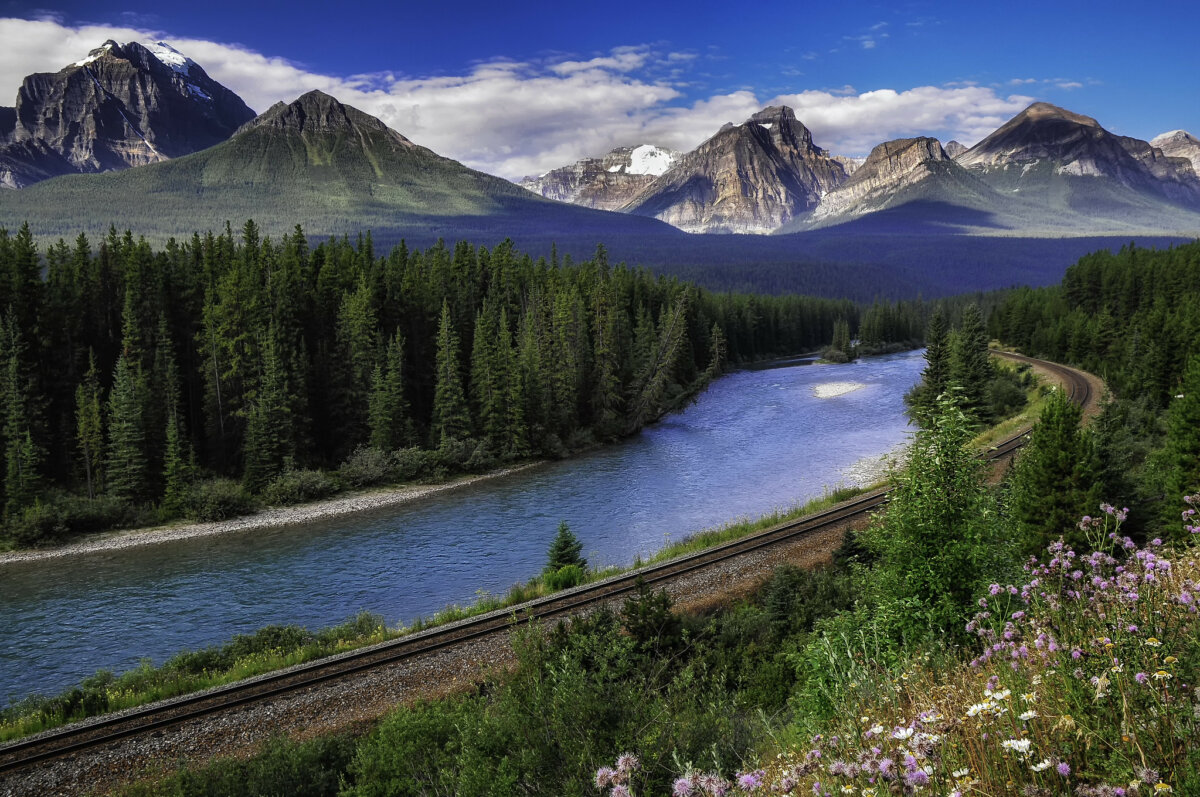
Morant’s Curve
Morant’s Curve is a roadside stop on the Bow Valley Parkway located at a part of the road where the Bow River gets quite close. You can stop for photos of not only the Bow River but the train tracks running beside it, the green forest behind it, and the peaks surrounding the river. Many photographers and visitors in general head here with the hopes of catching the CN Train chugging along through the Rockies.


