Overview
About Bow Valley Parkway Banff
Bow valley parkway viewpoint
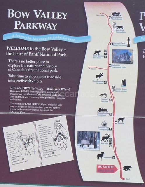
Bow Valley Parkway is a 51km scenic road and one of the two roads that link (Trans Canada Highway being the other) that connects Banff and Lake Louise.
The drive that cuts through mountains and passes over Bow river valley, is replete with panoramic views and wildlife.Site of an old boomtown with five operating mines and Canadian internment camp which held immigrant prisoners of Ukrainian, Austrian, Hungarian and German decent also lies along the Bow Valley Parkway.
Are you interested in Banff attractions, summer & winter activities and itineraries, if so see Attractions in Banff National Park
What to do at Bow Valley Parkway ?
Things to do at Bow Valley Parkway
- Marvel at the scenery, stop at pullouts and learn about the natural and geographical history through the interactive displays.
- Watch wild life. Bow Valley Parkway provides one of the best wild life viewing opportunity in Banff. As you travel along the Bow Valley Parkway; be on the lookout animals like Big horn sheep, deer, elk, grizzly bears and grizzly bears.
- Take a hike, picnic , camp or stay overnight at the resorts.
The below list describes in brief, the pull outs/interactive displays on the way from Banff to Lake Louise and the things to do at each of the stops of Bow Valley Parkway in Banff National Park. The distance mentioned is from Banff town centre.
Backswamp (9 km )
Learn how the Bow valley was formed at this marshy wetland interpretive display pullout. Watch out for Big horn sheep across the mountain side, and birds like Ospreys and Great Blue Herons. Fishing is also allowed here.
Mule Shoe (12 km)
At this interpretive display scenic pullout, named after horse shoe shaped pond called Mule shoe pond to your right; understand how the wetland was formed when Bow river changed its path. Also do not forget to look up to view the large mouthed cave created by the Bow glacier called the Hole in the wall to the east. Watch for elk. Picnic.
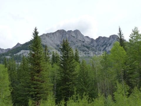
Hillsdale Meadows (19 km)
Try spotting wildlife at this pull out: this scenic viewpoint surrounded by aspen trees is one of the richest habitats for wildlife.
Johnston Canyon ( 25 km from Banff)
Spend time hiking at this spectacular Canyon formed by rushing waters 8000 years ago. This is a must do hike. Read this article for more about Johnston Canyon.
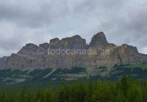
Moose Meadows (27 km)
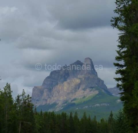
Stop at this pull out to view the imposing Castle mountain towering above the aspen forest. Spot the Eisenhower Tower. Spot the elk and deer on the meadow. At the west end, is the plaque that shows the location of Silver city.
Castle cliffs (32km)
Appreciate the stunning Alpine scenery with Castle mountain at the background.
Storm Mountain Bow valley Parkway
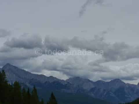
Storm Mountain (34 km)
Have a picnic and watch the clouds that swirl around the Storm mountain (Kootenay National Park) with Bow valley providing a velvety green foreground. The interment Camp memorial lies after the Storm Mountain lookout, just before Castle mountain Lookout trail.
Baker creek (46 km from Banff)
Yet another scenic pullout with the view of a mountain creek born near Skoki Valley, with Mount Temple providing a stunning backdrop.
Morant’s Curve (54 )
At this site, named after the photographer Nicholas Morant, be amazed by the panoramic view of rivers and rail lines and the ‘Canadian Alphs’. Spot the Harlequin ducks and American Dippers at the river down below.
Hikes on the Bow Valley Parkway
Silverton Falls
A short 1.0 km (one way) hike to a series of small lakes. Trailhead: Rockbound Lake parking lot, 0.2 km east of Castle Junction. GPS : 51.268209,-115.915751
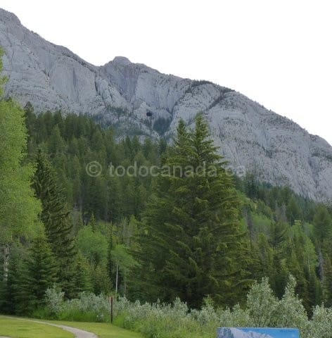
Hole in the wall ( black spot to the left of the tall middle tree top), Bow Valley Parkway
Castle Lookout
A moderate 3.7 km(one way ) to the remains of Castle lookout tower (fire spotting tower). Trailhead: 5 km west of Castle Junction on the Bow Valley Parkway.
GPS: 51.292512,-115.974207
Rockbound Lake
A long hike to Tower Lake (7.7 km) & Rockbound Lake (8.4 km) and beautiful scenery around. Trailhead: Rockbound Lake parking lot, 0.2 km east of Castle Junction on the Bow Valley Parkway. GPS: 51.268209,-115.915751
How to get to Bow Valley Parkway ?
Bow Valley Parkway location/directions
Speed limit – 60 km/hour or 37 miles/hour
From Banff town,
Head north on Banff Ave and turn left to Wolf Street. Turn right at Lynx St. Continue onto Mt Norquay Rd. Turn left onto the AB-1/Trans Canada HighwayTake . Take the Bow Valley ParkWay/AB-1A exit onto Bow Valley Pkwy
Castle Mountain – Eisenhower Tower
From Calgary,
AB-1 W/Trans-Canada Hwy, Take the Bow Valley ParkWay/AB-1A exit onto Bow Valley Parkway.
From Lake Louise,
Head southeast on Village Rd toward Lake Louise Dr. Take the 1st left onto Lake Louise Dr. Continue onto Bow Valley Pkwy.
Eastern end, GPS coordinates: 51.171204,-115.661083
Western end, GPS coordinates:51.424982,-116.16124
How much do Bow Valley Parkway scenic drive cost?
Admission/fees Bow Valley Parkway
Free, with Banff National Park Admission
More To Do in Canadian Rockies:
When to visit Bow Valley Parkway ?
Hours / Timing Bow Valley Parkway
Bow Valley Parkway
Bow Valley Parkway during winter season
Bow Valley parkway is open during winter season, but be cautious on the road due to icy conditions. Check road conditions, here
Bow Valley Parkway Closure
There is a mandatory travel restriction between the eastern section of Bow Valley Parkway and Johnston Canyon Campground(17km) to help the wild animals forage for food from March 1 to June 25 between 8:00 PM to 8:00 AM.
Access to Johnston canyon and rest of the parkway is through Highway 93 and TransCanada intersection which leads to Castle mountain village.- (details)
How long will it take to see Bow Valley Parkway ?
Depending on interest, one hour to well over half a day if one wants to hike at Johnston Canyon.What about Amenities, accessibility & parking?
Parking available at pullouts. Wheelchair Accessible
Castle Mountain Village provides accommodation, food , gas(fuel) and washrooms.
Baker Creek has a resort and a restaurant.
Johnston Canyon (seasonal) has campgrounds, washrooms and fuel.