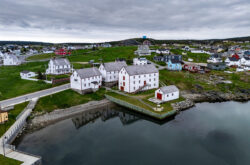
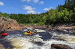
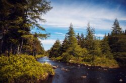
Newfoundland and Labrador is a beautiful province to hike on the tip of eastern Canada. It’s unique history and landscape comes to life, with stunning views from high peaks on the coastal tips, or gorgeous forestry and even inner-city hikes from down below. Whether in St. John’s, or atop a peak in Sunnyside, great hiking is to be found in Newfoundland and Labrador.
You may like to:
Explore Newfoundland and Labrador

Birch Brook Trails, Goose Bay
Length: ~20km
Birch Brook is home to a winter ski resort, but when the snow isn’t there, the trails that are used for skiing are also open to hikers. The Birch Brook trail system is lined with birches and other boreal forestry, from pines to towering maples. Underfoot, the trail is well-kept and mainly comprised of dirt and well-tamped down earth. Along the trail, several lookout points that overlook Lake Melville and the Mealy Mountains. With a wide variety of trails to choose from, you’re never lost for hiking opportunities during the off-season of the Birch Brook Resort. Trail Map
2. Alexander Murray Hiking Trail, King’s Point
Length: 8km
The Alexander Murray trail is perhaps one of the province’s most beautiful and sought-out hikes. It follows a series of staircases and dirt trails leading up to a viewing platform, climbing over 300m of elevation. Whilst only eight kilometres in length, the trail itself is strenuous due to the amount of climbing you’ll do — up — and down — all 2200 steps and various dirt tracks. Save for the stair-climbing, the terrain isn’t overly difficult. Trail Map
3. Humber Valley Trail, Humber Valley
Length: 25km
The Humber Valley Trail is a 25km stretch of the International Appalachian Trail, developed by the Newfoundland and Labrador chapter of the International Appalachian Trail System. The trail is diverse, with terrain going from muddy open forest land to stream crossings, and steep climbs up mountain passes (complete with spectacular views).
4. Indian Lookout Trail, Portland Creek
Length: 40km
The Indian Lookout Trail is another section of Newfoundland’s part of the International Appalachian Trail. The trail is a long section — forty kilometres in length, but it can be broken down into smaller subsections if you’re only looking for a day’s hike. However, for those seeking to go the distance, you’ll need about a week to complete the hike. The landscape surrounding the trail is gorgeous as it is nestled in between arctic fjords and Gros Morne National Park. If you’re lucky, you might spot some caribou on the trail, as they frequent the area. Other must-see sights include Partridge Pond Falls, a beautiful 1200-foot-high waterfall that only adds further beauty to the stunning scenery. The hike covers a multitude of terrain, from woodland to high cliffs and broken rock. It’s challenging in places but easy in others – a truly wonderful Newfoundland hiking experience. Trail Map
5. Centre Hill Wilderness Trail, Sunnyside
Length: 5km (each way)
Centre Hill Wilderness Trail in Sunnyside, Newfoundland, is not to be missed. It’ll bring you above the land and onto the highest peak overlooking the Avalon Peninsula. You’ll gain 345m of elevation along sometimes uneven and rocky terrain. It’s a tough hike up but provides stunning views from the top, so be sure to bring your camera. This short hike can be done in a day and is a great way to ease yourself into hiking in Newfoundland. Trail Map
6. Little Catalina Hiking Trail, Little Catalina
Length: 16.5km
This hiking trail from Little Catalina to Maberly runs right along the Bonavista Peninsula on Newfoundland’s east coast. The views from above are really what this trail is all about. The landscape is mostly brush, with many varieties of berries- from blueberries and blackberries to partridgeberry and cloudberry. Some are edible, some are not, so know what you’re snacking on. In May and June, icebergs can be seen, as well as a colony of seabirds at the end of the trail — of an island near Maberly. For those taking two or more days to enjoy the scenery, there is a camping platform located mid-way along the trail. Trail Map
7. Argentia Backland Trail, Placentia
Length: 10km
The Argentia Backland Trail is a popular excursion for hikers awaiting the ferry back to the mainland from the island of Argentia. Did you miss your ferry and have a few hours to kill before the next one? Well, strap on your backpack and hit the trail! With over 10 kilometres of trail, the Argentia Backlands cut through an old US Navy Base, offering beautiful views of the Bay of Placentia and surrounding areas. Other attractions include World War Two bunkers and other reminders of Newfoundland’s military past. It’s a short-ish trail at ten kilometres and would make for a great day hike. Trail Map
8. Skerkwink Trail, Port Rexton
Length: 5km
The Skerwink Trail skirts the north and south coast of Skerkwink Head, offering, at least according to its founder, “more scenery per linear foot than any other trail in Newfoundland.” The trail begins in Port Rexton and winds its way around the coast, offering beautiful views. The trail’s terrain is diverse, beginning in Port Rexton with flat, easy terrain before making its way out to the coast where the terrain becomes rocky and sometimes tricky. There’s always a rock face for you to admire, however. The trail is hectic in Spring and Summer, though the changing colours in autumn attract many people. At five kilometres, it’s hardly a backbreaker but will keep you appropriately entertained and challenged for at least a few hours. Trail Map
9. Fox Island Loop Trail, Champney’s West
Length: 4km
10. East Coast Trail, St. John’s
Length: 270km
By far the most challenging and longest hike in the entire province is the East Coast Trail, located near the capital city of St. John’s. This behemoth of a trail, at 270km, is the crown jewel of Newfoundland hiking experiences. The East Coast trail skirts, well, the east coast of Newfoundland, offering spectacular coastal views every step of the way along a trail purpose-built for hikers with moderately difficult terrain in places, ranging from stairs to dirt track to rocky in some places; it’s a challenging but beautiful hike. The scenery in every direction is, of course, what makes the trail — to your left, you have the open sea and the Avalon Peninsula, to your right, the beauty of the in-land of Newfoundland’s east coast, from towns and cities to sprawling woodland below. The East Coast Trail is a must-hike in Newfoundland, though, due to its length – if you intend to thru-hike it, you should expect to complete it in about ten days, perhaps allot two weeks, to give yourself a buffer. Trail Map
11. North Head Trail, St. John’s
Length: 1.7km A short but memorable hike in St. John’s is the North Head Trail — you guessed it — the trail that circumferences the northern tip of Newfoundland. Located off a dirt road down Cuckholds Cove Road, continuing around the northern tip of Newfoundland and finding the road again at Outer Battery Road, near a historic military fort. The trail itself is a relatively easy hike, with mostly flat terrain, despite the elevation above sea level — and at less than 2km long, it makes for a perfect afternoon hike. The scenery is beautiful and the location is rich with military history, so you are free to make some excursions along the way to appreciate the plaques and other monuments which line the coast. Trail Map
12. Corner Brook Gorge Trail, Corner Brook
Length: 3.9km
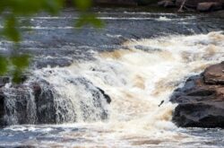
The Corner Brook Gorge Trail bypasses the Corner Brook Stream, which coincidentally has a trail of its own. Corner Brook Gorge trail is a relatively short three-kilometre hike around the Corner Brook Gorge to Crocker’s Road from Margaret Bowater Park. The trail cuts mainly through woodland, so scenery is minimal, but that shouldn’t detract from the beauty of the woods and the shadows along the trail during the height of summer or the beauty of the leaves during the fall months. The Corner Brook Gorge is one of the highlights of the trail; churning water barreling down a rocky face makes for some fantastic photos — the pine trees in clumps along the rock face on either side only add to the picturesque nature of one of Corner Brook’s most sought-after and beautiful hikes.
Trail Map
13. Corner Brook Stream Trail, Corner Brook
Length: 7km
14. Goowiddy Path, Terra Nova National Park
Length: 8km
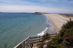
Terra Nova National Park is home to over 80km worth of hiking trails, so you really are spoiled for choice! The Goowiddy Path is an eight-kilometre loop trail which takes in some of the best of Terra Nova. It’s a relatively easy eight-kilometre stroll through a balsam fir forest, which snakes the coastline of the Newman Sound. You’ll come to a junction — keep right until you discover a sandy beach — a perfect place for a lunchtime picnic mid-trail. Once you’ve eaten, you’ll return to the forest for another few kilometres before coming to the awesome Buckley’s Cove, where a beautiful open ocean and gorgeous seaside scenery await you. There’s also a back-country campground located here for those wishing to stay the night. For those wishing to do more — there’s a trek to be made to Blue Hill Pond, where you’ll see yet more of the beauty of Terra Nova National Park — a boardwalk will take you back to the coastline to conclude the hike. The Goowiddy Path is a great way to spend a day in Terra Nova National Park.Trail Map
15. Ochre Hill Trail, Terra Nova National Park
Length: 4.5km
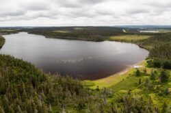
The Ochre Hill trail is a two-part trail in Terra Nova National Park, located approximately two-thirds of the way up Ochre Hill Road, which runs from Highway 1 (part of the TCH) to the Ochre Hill Fire Tower. The first part of the trail is a loop which goes around a beautiful open body of water high above the forest floor — offering serene views of the beauty of Terra Nova. That takes up 3.5km of the trail, the extra 1 kilometre is optional but definitely worth it if you have the time and inclination. This trail follows the forest floor and is a branch-off trail with a dead end, meaning you’ll have a return trip of 1 kilometre also. Ochre Hill trail is a beautiful trek up Ochre Hill on dirt forest tracks with a slow incline. A beautiful hike at any time of year. Trail Map
Newfoundland and Labrador is one of Canada’s most beautiful provinces and yet it is often overlooked — perhaps it is its separation from the mainland which is the cause — regardless, one should most definitely not overlook this gorgeous eastern province, with opportunities to experience nature, history and the glory of Canada’s animal kingdom all in one place. If you’re going anywhere near the east coast, why not go all the way east and hike in Newfoundland and Labrador?


Great list! Thanks so much 🙂 Of all the hiking I’ve done, I still have a bunch to do on your list…can’t wait!
I don’t understand how you can have those two “hikes” in corner brook but not have the man in the mountain hiking trail which brings upon top and looking down into the humber valley and out the bay of islands. That is an amazing beautiful hike. Not just a walk around corner brook
ummm…gros morne?!?!!?!?!?1
Great hikes! I would add The Gravels trail in Port au Port
Hi there great read but there is one that gets miss out a lot a 65km hike I have done it both ways camping along the way that is the Labrador Pioneer Footpath that runs from Pinware to L’aus Au Clare hike inand out of the villages along the way and the trail walks long the lighthouse at Point Amour hear is a link to the trails https://www.labradorcoastaldrive.com/home/156
No worries ! Promoting all hiking in NL is awesome. I highly recommend checking out the trails in the Bay of Islands. They are the most underrated in the province! Spectacular coastline scenery and challenging trails
We were supposed to do one article on “hiking in Gros Morne”(https://www.todocanada.ca/top-10-things-gros-morne-national-park/) and include it here. We will amend it soon.
Great list! Curious as to why you didn’t include any trails from Gros Morne or the Bay of Islands? They are the best trails on the island. Cheers
I’m pretty sure the Center hill hike you speak of is in Sunnyside and not Trinity. I’ve done this one. The view at the top is beautiful!
Yes, It is in Sunnyside.