(902) 422-5979
5425 Sackville St, Halifax, Canada
May to October
The Army Museum at the Halifax Citadel has more than 70,000 military artifacts that showcases the military history of Atlantic Canada. Read more…

(902) 422-5979
5425 Sackville St, Halifax, Canada
May to October
The Army Museum at the Halifax Citadel has more than 70,000 military artifacts that showcases the military history of Atlantic Canada. Read more…

902-425-7770
1055 Marginal Road, Halifax, NS B3H 4P7
Year Round, hours Vary
The Canadian Museum of Immigration at Pier 21 is Canada’s sixth national museum. Read more…
902-496-8257
5865 Gorsebrook Ave, Halifax, NS B3H 3C3
Year Round, House Vary
Named in honour of Reverend M. W. Burke-Gaffney , S. J (1896-1979), and its Dr. Ralph M. Read more…
(902) 425-7777
1983 Upper Water Street, Halifax, NS B3J 3Y5
Round the year
Casino Nova Scotia offers gaming, with 650 slots and table games, restaurants, and is also Atlantic Canada’s largest gaming and entertainment destination. Read more…
902-873-3773
20 Sky Boulevard, Goffs, NS
Seasonal
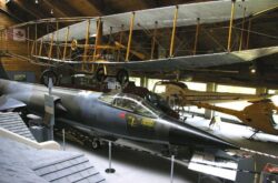
Explore the extensive civilian and military aviation history of Atlantic Canada depicted at the Atlantic Canada Aviation Museum. Read more…
902.424.5280
1723 Hollis Street, Halifax, NS B3J 1V9
Year Round, Hours Vary
Explore historic and contemporary Nova Scotian, national and international paintings, sculptures, drawings, and other art works, housed in two renovated heritage buildings in downtown Halifax and Yarmouth. Read more…

866-687-2327
Winnipeg, MB, Canada
August
This tour is organized by Lazy Bear Expeditions, is a 5-day adventure and cultural experience of the arctic landscape in summer. Read more…
800-661-3830
Winnipeg, MB, Canada
Seasonal
Arranged by the The Great Canadian Travel Company, are for people looking to experience more than just the wildlife this region has to offer. Read more…
800.565.2595
Atikaki Provincial Park, MB
Arranged by the Aikens Lake Wilderness Lodge, a fishing lodge situated in Atikaki Provincial Wilderness Park, this trip is perfect for adventurers with a penchant for wilderness.… Read more…
204-949-2050
Churchill, Manitoba, Canada
Seasonal
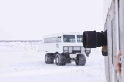
This tour organised by Frontiers North explores the wild tundra landscape in a specially designed all-terrain Tundra Buggy vehicle providing optimal photography opportunities and wildlife viewing. Read more…

8668469453
Winnipeg, MB, Canada
July & August
Organised by Churchill Wild explores the wild tundra landscape for over 5 days. Read more…

(204) 636-2968/(877) 636-2968
Winnipeg, MB
Organised by Churchill Nature Tours, explore Winnipeg to Churchill and cover 1710 kms in 9 days. Read more…

204-945-5813
450 Broadway, Winnipeg, MB R3C 1S4, Canada
Year Round
Manitoba Legislative Building houses the legislative assembly and stands as a symbol of the strength and vitality of the capital city. Read more…

404-268-CITY (2489)
325,25 Ave. S.E, Calgary, AB, T2G 5V1
Dawn to Dusk
Superintendent of the City of Calgary’s Parks Department from 1913-1943, William Reader, creating the “rockery” on the steep north slope of Cemetery Hill , now known as… Read more…
403-864-6000
5037 50 Street, Sylvan Lake, AB T4S 1P9
Year Round
Bonavista Fine Art is a commercial art gallery and studio located in Sylvan Lake, Alberta, featuring original art created by local artists, in various mediums and styles.… Read more…
1-204-855-3246
Oak Lake, MB R0M 1P0
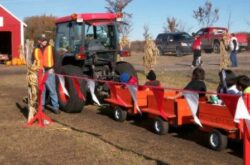
Meandher Creek Pumpkin Patch offers lots of fun family activities including zip-line, corn trail, duck races, pumpkin trains, petting zoo, bale pyramids, pig races, hay rides and… Read more…
1-204-371-5556
Box 42 Grp 3 RR1, Steinbach, MB R5G 1L9
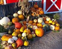
Penner Pumpkins and the Scarecrow Forest is 10 acres of farm attraction with over 30 activities for all ages. Read more…
204-237-7692
866 St Joseph Street, Winnipeg, MB
Seasonal - May Mid to Late August
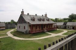
Fort Gibraltar was originally a fur trade post, built in 1810 at the Forks of the Red and Assiniboine Rivers by the North West Company. Read more…
(204) 222-1137
59 North Drive, Oakbank, MB, Canada
Monday - Sunday: 10:00 am - 7:00 pm
Friday - Saturday: 10:00 am - 8:00 pm
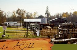
Visitors can enjoy horseback riding or go for a scenic trail ride around the Birds Hill Park and see deer, owls, and other animals or go on… Read more…

245 Smith St, Winnipeg
Year Round
The Museum is displays artifacts related to the history of the Winnipeg Police Force, dating from its beginning in 1874. Read more…

(204) 615-3951
329 Cumberland Avenue, Winnipeg, Manitoba R3B 1T2, Canada
Wednesday-Saturday, 12-4pm
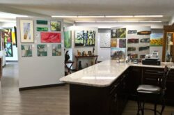
About C2 Centre For Craft The Museum is Canada’s Only Museum of Craft featuring contemporary and historical craft in the province. C2 is a shared initiative of the Manitoba… Read more…
(204) 477-7460
123 Doncaster St, Winnipeg, MB R3N 2B2
The Marion and Ed Vickar Jewish Museum of Western Canada at the Jewish Heritage Centre is the only museum in Canada dedicated to collecting information relating to… Read more…

(204) 586-6298
551 Machray Ave, Winnipeg, MB R2W 1A8
The museum displays the history of the Fort Garry Horse Regiment from its origins to the present time through use of artifacts, photographs and archival material. Read more…

969 St Matthews Ave, Winnipeg, MB R3G 0J7
The Museum is dedicated to collecting, preserving and displaying of military artifacts, pictures, books, documents etc. of Western Canada’s oldest Infantry Regiment. Read more…