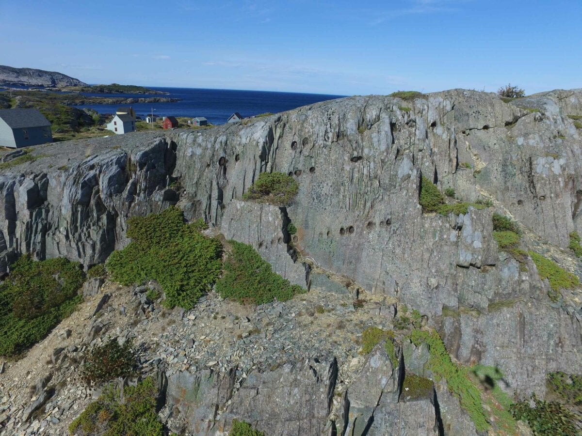
The town of Keels surrounds the Cove of the same name, and Keels Cove is a unique site to behold. The rocks and cliffs between the Main Road and Keels Cove feature large cavities in the rocks known as the Devil’s Footprints.
Credit: Discovery Geopark
These footprints go up the taller cliffs and rocks and across the rocks on the ground. The linear pattern of some of the rock divots/footprints does appear as though they were intentionally put there. These are, however, totally natural occurrences!
You may like:


Visiting Keels and the Devil’s Footprints
These rock formations are located beside the Newfoundland community of Keels. It is a beautiful community about 45 minutes drive from Bonavista, where you can take a walk or bike ride, with a handful of local businesses to explore.
- Stop by Mikey D’s Ice Cream for a snack or Maudie’s Tea Room for a sit-down meal. You may also catch some live local musical acts from Maudie’s Tea Room during the summer months. This café is located on the waterfront and has a patio overlooking the ocean.
- Keels is a quiet and small community with some of Newfoundland’s quintessential scenery: colourful seaside homes, the diverse foliage before you get to the cliffs, and the Atlantic Ocean.
Where to Stay near Keels
If you plan to make a full vacation or getaway out of the Bonavista Peninsula or the Discovery Global Geopark Sites, then there are options closer to Keels and King’s Cove. Plus, Bonavista offers several more options.
- Plate Cove’s Round Da Bay Inn is about 25km south of Keels with 16 different theme rooms, a gift shop, and a restaurant.
- The Hillside Campground will bring your stay close to another of the Geopark’s sites: the King’s Cove Lighthouse and Trail. The campground offers RV sites and tiny home cabins.
- These private cottage rentals bring your stay close to Keels, Duntara, King’s Cove, and Amherst Cove.
More to See near Keels & the Devil’s Footprints
There are two more Discovery Global Geopark sites within a short drive from Keels; one location is to the west, and another to the east to offer the picture-perfect coastal drive, getaway, or day trip.
- The King’s Cove Lighthouse Trail, east of Keels, can be accessed by a quick 1.5km out-and-back hike, or a longer 3.7km loop around the area.
- Find another nearby Geopark site east of Keels at Tickle Cove. While a short distance east, the rocky terrain creates a detour south from Keels to access the Tickle Cove Sea Arch. To view the arch, take a short but gorgeous hike out to the next unique, cool, and photo-worthy geological feature of this coast.
Planning your Trip – Devil’s Footprints in Keels
What: The Devil’s Footprints in Keels intrigue visitors with their eerie resemblance to cloven hooves, blending local folklore with natural geological explanations.
Devil’s Footprints are rock cavities that result from carbonate nodules eroding at the rock. To visitors, the Devil’s Footprints appear as divots, or “footprints” in the rocks around the town of Keels.
Location and how to get there: Take the Bonavista Bay Highway from the east or the west to reach King’s Cove. From here, follow Top Road north toward Keels. There are marked signs in town directing visitors to parking and the footprints.
Keels is located approximately 3 hours drive (272 km) from St. John’s.
Cost: free
Best time to go: May-October
For more information:


