A 6.4-magnitude* earthquake struck off the coast of British Columbia’s Vancouver Island on Thursday morning, as reported by Earthquakes Canada.
Credit: Earthquakes Canada
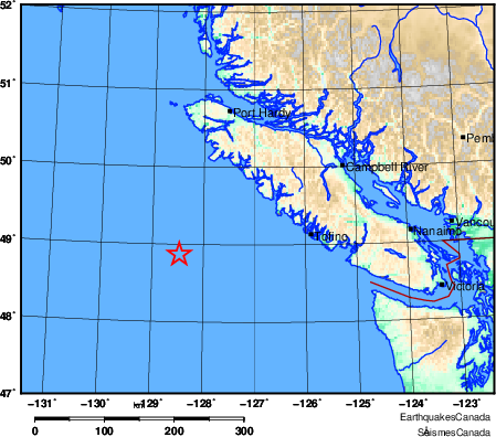
The seismic event occurred approximately 183 kilometres southwest of Port Alice and 209 kilometres from Tofino, with the exact time of occurrence being 8:08 a.m. local time. The earthquake’s epicentre was situated at a latitude of 48.87 North and a longitude of 128.47 West, at a depth of 10 kilometres.
Earthquakes Canada says it was lightly felt on Vancouver Island, and no tsunami warnings were issued following the event.
The agency, on its website, states that the area is “experiencing a swarm of earthquakes offshore Vancouver Island, at the intersection of the northern Juan de Fuca Ridge, Sovanco Fracture Zone, and Nootka Fault Zone.”
Following the 6.4 magnitude earthquake, a series of smaller quakes offshore were also measured:
- 4.8 magnitude, 197 km SW of Port Alice
- 4.9 magnitude, 166 km SSW of Port Alice
- 4.3 – 194 km SW of Port Alice, BC
According to the U.S. Geological Survey, there is a 99% chance of at least one aftershock of greater than magnitude 3 within the next week.
*Update: The article is updated to reflect the latest magnitude, 6.4 and the series of earthquakes felt in the region. Earthquakes Canada originally reported the seismic event as one with a magnitude of 6.1 and that there were no reports of the earthquake being felt by residents.


