Environment Canada has upgraded storm warnings to Category 1 Hurricane for PEI, parts of Nova Scotia and Newfoundland.
Credit: Canadian Hurricane Centre
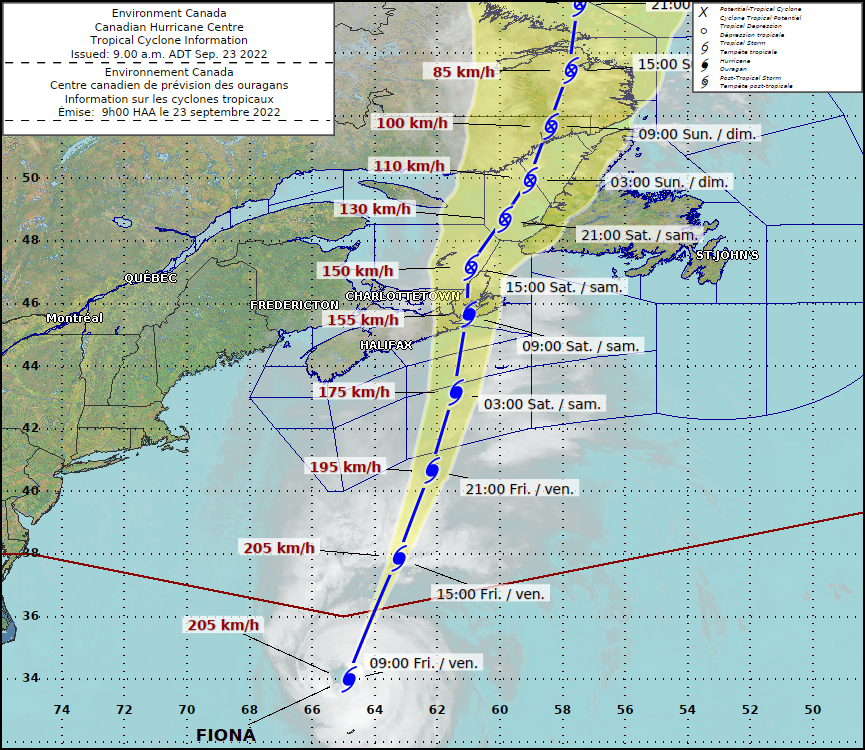
Fiona, currently a category 3 storm, is expected to make landfall as an intense post-tropical storm or Category 1 Hurricane over Eastern Mainland Nova Scotia or Western Cape Breton early Saturday morning while decelerating slightly and maintaining sustained hurricane force winds.
Latest forecast says Fiona will travel northeastward faster and will turn more east after moving near the Magdalen Islands before heading into Southeastern Labrador and then out to sea.
Environment Canada expects category-two hurricane threshold wind gusts with wind speeds of 160 km/h in some areas such as eastern Cape Breton and southwest Newfoundland east of the eye. Winds of near category-two hurricane threshold are also expected for Kings County in PEI and a Wreckhouse wind warning (issued when there is a significant risk) is in effect for Channel-Port aux Basques and vicinity as it is expected to experience southeasterly up to 170 km/h.
Severe winds and rainfall with major impacts are expected for eastern Prince Edward Island, eastern Nova Scotia, southern and eastern New Brunswick, western Newfoundland, eastern Quebec, and southeastern Labrador.
Currently, hurricane warnings are in effect for PEI and the following places:
National Hurricane Center And Central Pacific Hurricane Center
Newfoundland:
- Bay St. George
- Burgeo – Ramea
- Channel-Port aux Basques and vicinity (with Wreck house wind warnings of speeds up to 170 km/hr)
- Corner Brook and vicinity
- Gros Morne
Nova Scotia:
- Antigonish County
- Colchester County
- Guysborough County
- Halifax County
- Halifax Metro
- Inverness County
- Pictou County
- Richmond County
- Sydney Metro and Cape Breton County
As per Environment Canada, a hurricane warning means sustained winds near 120 km/h or more, and/or significantly elevated water levels and dangerous surf along the coast.
National Hurricane Center And Central Pacific Hurricane Center
Tropical storm warnings are in effect for Acadian Peninsula, Bathurst and Chaleur Region, Campbellton and eastern half of Restigouche County, Grand Lake and Queens County, Grand Manan and Coastal Charlotte County, Kent County, Kouchibouguac National Park, Miramichi and area, Moncton and Southeast New Brunswick, Mount Carleton – Renous Highway, Oromocto and Sunbury County, Saint John and County, Stanley – Doaktown – Blackville Area, and Sussex – Kennebecasis Valley and Kings County in New Brunswick.
Southern Quebec regions including Anticosti, Blanc-Sablon, Chevery, Forillon National Park – Gaspé – Percé, Grande-Vallée area, Îles-de-la-Madeleine, Minganie, Murdochville area, Natashquan, New, Carlisle – Chandler, and New Richmond – Bonaventure area are under Tropical Storm warning.
Environment Canada says there is a high likelihood of storm surge for parts of Nova Scotia, the Gulf of St. Lawrence and western Newfoundland and large waves, especially for the Atlantic coasts of Nova Scotia, Newfoundland, and eastern portions of the Gulf of St. Lawrence.
Storm surge is expected for the north to northwest facing shorelines of Prince Edward Island, Iles de la Madeleine, northwestern Cape Breton, eastern Chaleur-Miscou, and parts of the Northumberland Strait exposed to the north to northwest from Saturday morning until noon.
Structural damage to buildings, and construction sites plus prolonged and widespread utility outages are expected due to heavy winds.
Eastern Nova Scotia, southwestern Newfoundland, and the Gulf of St. Lawrence region can expect heavy rainfall of up to 200 mm leading to flooding and road washouts.
Storm surge is also expected for parts of Nova Scotia, the Gulf of St. Lawrence and Newfoundland with 10-meter high waves expected to reach the eastern shore of Nova Scotia on Friday night and southern Newfoundland by Saturday morning.
Environment Canada says eastern portions of the Gulf of St. Lawrence could see waves higher than 12 metres and the western Gulf will see waves from the north up to 8 metres leading to probable erosion of Iles-de-la-Madeleine coast, and north-facing beaches of Prince Edward.
The maximum water levels are expected Saturday morning due to the high tide.
More Information & Latest Warnings