Residents are being warned to prepare for a hurricane-force storm “shaping up to be a severe event” in Atlantic Canada and eastern Quebec.
Canadian Hurricane Centre
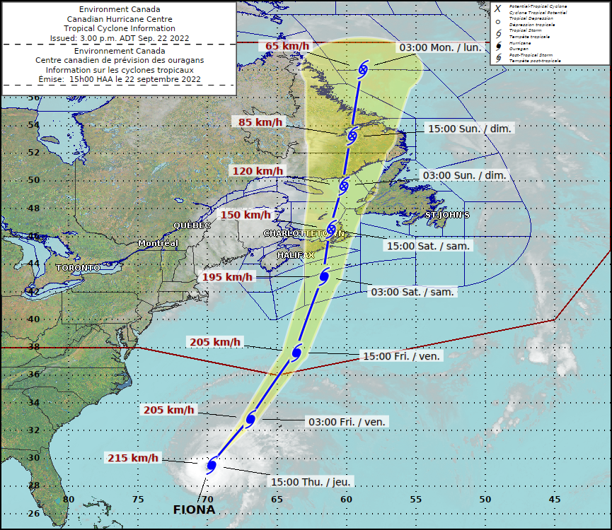
Environment Canada has issued a tropical cyclone warning as Fiona, currently a category 4 hurricane, is expected to make landfall as a post tropical storm on September 24th. The weather agency says most regions will experience severe winds starting late Friday and rainfall beginning as early as Friday morning.
As per the latest forecast, Fiona is expected to enter “Nova Scotia waters on Friday, passing through eastern Nova Scotia and Cape Breton Saturday, and then reaching the Lower Quebec North Shore and Southeastern Labrador early Sunday.”
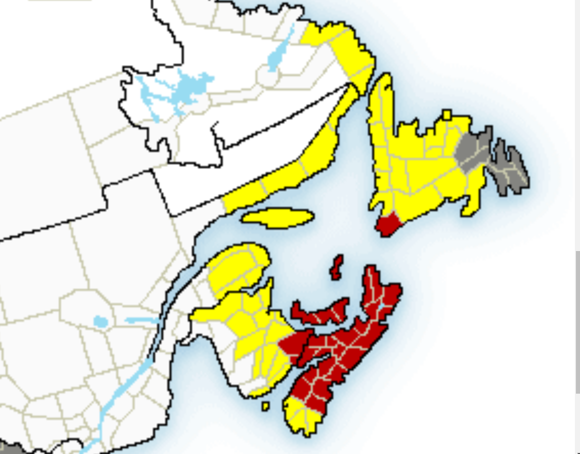
Tropical Cyclone warnings are in effect for Nova Scotia, Prince Edward Island and the following places in Quebec, New Brunswick and Newfoundland and Labrador:
Credit: Environment Canada
New Brunswick:
- Acadian Peninsula
- Bathurst and Chaleur Region
- Campbellton and eastern half of Restigouche County
- Grand Lake and Queens County
- Grand Manan and Coastal Charlotte County
- Kent County
- Kouchibouguac National Park
- Miramichi and area
- Moncton and Southeast New Brunswick
- Mount Carleton – Renous Highway
- Oromocto and Sunbury County
- Saint John and County
- Stanley – Doaktown – Blackville Area
- Sussex – Kennebecasis Valley and Kings County
Newfoundland and Labrador:
- Cartwright to Black Tickle
- Newfoundland
- Norman Bay to Lodge Bay
- Red Bay to L’Anse-au-Clair
Québec – south:
- Anticosti
- Blanc-Sablon
- Chevery
- Forillon National Park – Gaspé – Percé
- Grande-Vallée area
- Îles-de-la-Madeleine
- Minganie
- Murdochville area
- Natashquan
- New Carlisle – Chandler
- New Richmond – Bonaventure area
Environment Canada says structural damage to buildings, and construction sites plus prolonged and widespread utility outages are expected due to heavy winds.
Eastern Nova Scotia, southwestern Newfoundland, and the Gulf of St. Lawrence region can expect heavy rainfall of up to 200 mm leading to flooding and road washouts.
Storm surge is also expected for parts of Nova Scotia and Newfoundland. As per a tropical cyclone warning from Environment Canada, 10-meter high waves are expected to reach the eastern shore of Nova Scotia on Friday night and southern Newfoundland by Saturday morning.
Environment Canada says eastern portions of the Gulf of St. Lawrence could see waves higher than 12 metres and the western Gulf will see waves from the north up to 8 metres leading to probable erosion of Iles-de-la-Madeleine coast, and north-facing beaches of Prince Edward.
More Information