Saskatchewan is home to unique, naturally occurring, geographically interesting terrains and features many people are unaware of!
Visit every one of these destinations in this list of unusual/unique places and rediscover this prairie province of Canada!
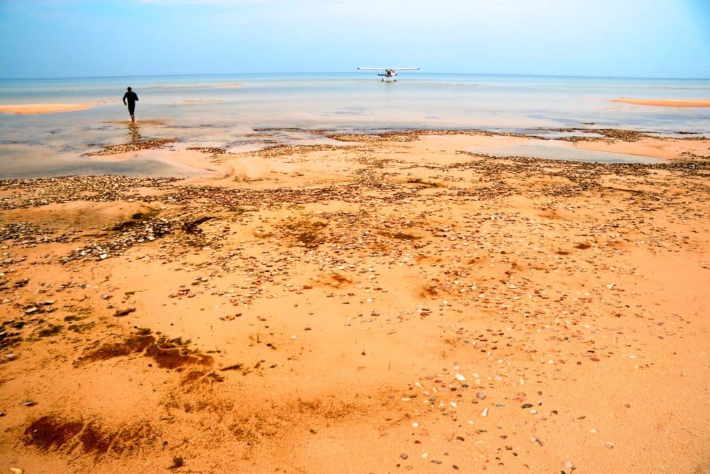
1. Athabasca Sand Dunes
Credit: Tourism Saskatchewan
Did you think Saskatchewan is a flat, boring piece of land? Think again!
In the northwest part of Saskatchewan, there are dunes that stretch 100 kilometres along the south shore of Lake Athabasca.
The Athabasca Sand Dunes are the largest active sand surface in North America and the world’s most northerly major sand dunes.
These sand dunes support a unique ecosystem and scarce plant life. Athabasca Sand Dunes Provincial Park protects this unique feature in the boreal shield ecosystem. This area is accessible only by float plane.
When: Year-round – Best to Visit Late Spring to Fall.
Where: Athabasca Sand Dunes Provincial Park, La Ronge, SK.
Phone: 306-425-4234
Email: LacLaRonge@gov.sk.ca
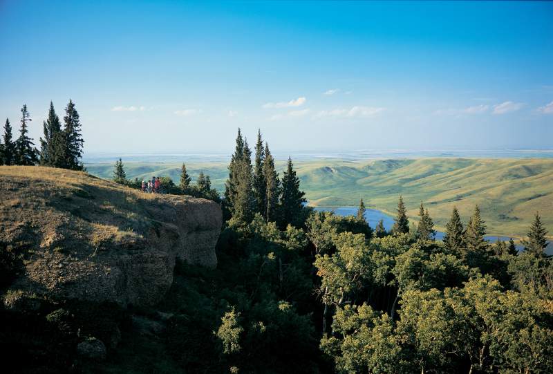
2. Cypress Hills
You might wonder what Cypress Hills is doing on this list! Within Cypress Hills, Interprovincial Park is the highest point in the province – 1.39 km above sea level. The Conglomerate Cliffs in the west block also have the highest elevation between the Rockies and Labrador.
The Cypress Hills rise several feet above the surrounding prairie, making it a geographic anomaly in the prairie province. Because of this unique geological feature, many rare plants and animals thrive in the park. Details
When: Year-round, Conglomerate Cliffs Hike — May to November
Where: The Conglomerate Cliffs, west block Cypress Hills Interprovincial Park
Phone: 306-662-5411
Email: CypressHills@gov.sk.ca
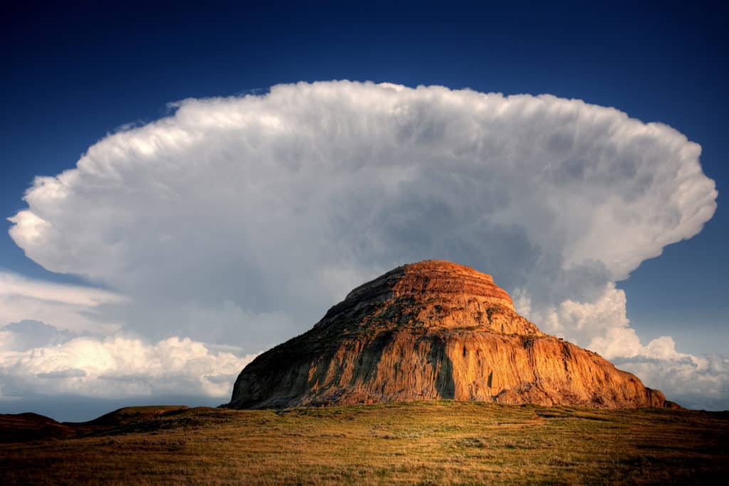
3. Castle Butte and The Big Muddy Badlands
Credit: Tourism Saskatchewan Greg Huszar Photography
Big Muddy Badlands, located in Big Muddy Creek inside the Big Muddy Valley (55 km long, 3.2 km wide and 160 m deep), is one of the most rugged and driest regions in Saskatchewan.
The Valley was carved from an ancient glacial meltwater channel during the last ice age. Once you reach here, the flat land, so typical of Saskatchewan, is no longer seen. Instead, you will see wind-carved buttes, prickly-pear cacti, cliffs, and deep-cut sandstone ravines. These rugged buttes are from the sedimentary layering process over several geological periods.
The area is also dotted with caves carved from the landscape. One of the most significant geological features is the Castle Butte, a 70 m high sandstone and clay formation. The Town of Coronach arranges guided tours of the Big Muddy Badlands.
When: The best way to see the area is to take the tour offered. Tours are available in July & August.
Where: On Highway 34, south of Bengough, north of Big Beaver.
Book the tour @ Big Muddy Creek, Town of Coronach, SK. Phone: 306-267-3312
4. Massold Clay Canyons
Located an hour southwest of Regina and beside the Claybank Brick Plant National Historic Site is the Massold Clay Canyons. The Massold Clay Canyons are renowned for the white mud formation formed during the Cretaceous period.
Two different types of clay can be seen in the formation: white and grey, each with different properties. The Claybank clay is ‘high-refractory,’ referring to its excellent heat and pressure-bearing properties, making them an excellent choice for bricks and tiles.
Near the Massold Clay Canyons is the Claybank Brick Plant National Historic Site, where bricks have been manufactured since 1914. This brick plant is one of Canada’s best-preserved examples of early 20th-century industrial activity.
When: July 1 – August | Daily; September | By appointment
Where: Claybank, SK
Claybank Brick Plant National Historic Site is located 15 kms West of Avonlea on Hwy #339 or 1 km East of Claybank Village on highway #339
Phone: (306) 868-4474
Email: claybanktours@gmail.com
5. The Great Sandhills
As you travel across Saskatchewan, you will be surprised at the number of sand dunes this prairie region possesses! Though less well-known than the Athabasca Sand Dunes, Great Sandhills holds its place in the list of geographically unique places in the province.
The Great Sandhills is one of the most extensive sets of active sand dunes in Canada, lying within the Great Sandhills Ecological Reserve. The Sandhills cover 1900 square km. These dunes are perpetually moving, thereby creating an ever-changing landscape.
This piece of the area is visited by various bird species. You can also see aspen, birch and wildlife, including the rare Ord’s Kangaroo Rat. Drop in at the Great Sandhills Museum & Interpretive Centre before you journey to the dunes.
When: Great Sandhills Museum & Interpretive Centre: May 15 – August 31 | Daily
Dunes are open year-round.
Where: Great Sandhills are located in the Great Sandhills Ecological Reserve. The Great Sandhills are 27 km south of Sceptre, 47 km southeast of Leader, 137 km south of Kindersley, and 159 km northwest of Swift Current.
The Great Sandhills Museum & Interpretive Centre is located in Southwest Saskatchewan on Highway 32, in the village of Sceptre.
6. Nipekamew Sand Cliffs
Nipekamew Sand Cliffs are unique geological formations dating back to the last ice age. They are located an hour southeast of La Ronge along the banks of the Nipekamew River.
The sand cliffs are made of layers of compacted sand, pebbles and clay deposits. The erosion of the cliffs has made them extremely fragile, so tourists are asked to respect this fragile piece of environment and not to damage it.
The trailhead to the sand cliffs is from a narrow dirt road on the west side of the Nipakamew River along Highway 165. Walk 1.5 km from the parking lot to reach the sand cliffs.
When: Year-round
Where: La Ronge, SK
27 km East of junction Hwys 2 & 165, towards Nipekamew River; follow the road south on the west side of the river for 1.2 km to parking area. Hike the 1.5 km primitive trail to the sandstone cliffs.
Phone: (306) 425-4234
Toll Free:(800) 772-4064
Note: The sand cliffs are located on protected land. Stay on the west side of the river to view them.
7. Sand Dunes at Douglas Provincial Park
At the northeast part of Douglas Provincial Park are active dunes stretching more than 1 km long and as high as 30 m. This landscape is accessed via a hiking trail.
The 5 km long Cacti Trail starts at the Interpretive Centre and follows along grasslands, aspen groves, and later, arid land with sparse vegetation. All the trees and shrubs in this region have stunted growth, but surprisingly, abundant wildlife can be seen with many different bird species.
When: Year-round
Where: Douglas Provincial Park, Elbow, SK. The park is located 11 km South of Elbow on Hwy 19.
Phone: (306) 854-6266
Email: DouglasPark@gov.sk.ca
8. Twisted Trees of Alticane
Although not a geographic phenomenon, the Crooked Bush at Hafford is a natural anomaly.
Located northwest of Hafford, 75 minutes north of Saskatoon, is a group of warped and twisted aspen trees. Local legends attribute it to various things, from UFO landing to a lightning strike.
This 3-acre grove is located in the Redberry Lake Biosphere Reserve, where visitors can walk along the broad walk enjoying the unique trees. Along the walk, display boards explain some of the theories behind about made the trees grow like this (including genetic mutation). They are also known by other nicknames such as Trembling Aspen, Crooked Bush, and Quaking Aspen. Details
When: Year Round
Where: Redberry Lake Biosphere Reserve, Hafford, SK
Direction from Hafford: 14.5 km west on Highway 40, past Speers to the Flint Road, north 16 km, east 2.5 km.
Directions to Crooked Bush: Past Speers on Hwy. 40 to Flint Road and follow the sign “Crooked Bush.”
Start: At the parking lot; Length in total: 200 meters (loop)
Phone: (306) 549-2360
Email: info@redberrylake.ca
9. Fossils at Grasslands National Park
Experience the excitement of digging for fossils at the Grasslands National Park. The east part of the park features the Killdeer Badlands of the Rock Creek area and is representative of the Wood Mountain Uplands.
The badlands were untouched by glaciers from years ago and now have multicoloured hues from the exposed layers of Bearpaw, Eastend, Whitemud, Frenchman and Ravenscrag formations. This landscape, with its exposed sedimentary rock, has many fossil deposits.
Did you know that the first dinosaur remains in Western Canada were discovered here? The park arranges various guided events and programs where visitors can join the fossil dig team. However, if you prefer to go fossil hunting on your own, be sure to stop at the East Block Visitor Centre, where you will guide as to what to look for and where.
When: Victoria Day Weekend to Thanksgiving Day
Where: Grasslands National Park is located in southwestern Saskatchewan near the Saskatchewan-Montana border.
The Park’s East Block can be accessed near Wood Mountain on Hwy #18.
McGowans Visitor Centre, East Block:
Phone: 306-476-2018 (East Block McGowan’s Visitor Centre at Rock Creek Campground)
10. Creighton Limestone Crevices
Located in northeast Saskatchewan are spectacular limestone crevices that look like the earth suddenly cracked open. These limestone crevices were formed from the cracks in the carbonate rock of the Red River formation. The crevices appeared when water seeped along the crack froze, and expanded repeatedly, wedging the rocks apart and forming the crevices.
When: Year-round – Best to visit from Late Spring to Fall.
Where: 1 km north of Meridian Creek on Highway 167 (The South Weir Rd) and along the south shore of Amisk Lake.
Note: Supervise children if you are taking them along, and be highly cautious while exploring the crevices.
11. Little Manitou Lake
Although Saskatchewan has over a hundred thousand lakes, Little Manitou Lake near Watrous is unique. Called Canada’s own Dead Sea, the lake is fed by underground springs and has a high content of sodium, magnesium and potassium salts. This means you can float effortlessly on the water while enjoying the healing properties of the water. The lake is located 1.5 drive southeast of Saskatoon.
When: Year-round. Best time to visit: June – August
Where: Watrous, SK
Sand Castles and Sunken Hill at Beechy (Closed to Public)
These are large natural sand castle formations seen 7.2 km west of Beechy. Drive along the Beechy Sandcastles and Sunken Hill Trail to see breathtaking views of giant sand dunes, teepee rings and the famous Sunken Hill. This was formed when a plateau hill suddenly collapsed and sank from a natural gas pocket. You can see abundant wildlife, amphibian and bird species here. Other attractions in this area are Snakebite Coulee and Magnesium Sulphate Lake.
Since 2019, this area has been closed to the public.
Directions
You might like: Waterfalls of Saskatchewan