After a winter shaped by La Niña and a disruptive polar vortex, Canadians shouldn’t expect a smooth slide into summer. The Weather Network has released its 2026 spring outlook for March, April and May, and the message is clear: the path ahead looks uneven.
Credit: The Weather Network
Senior meteorologist Doug Gillham says spring in Canada rarely follows a straight line, and this year will include “detours” and even brief returns to winter. While warmer days will arrive, they may not stick around for long. In some regions, he notes, the shift to summer could happen abruptly.
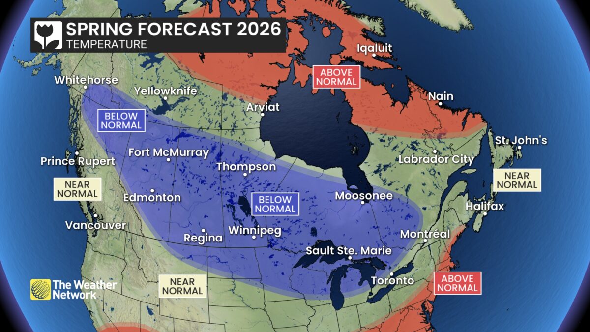
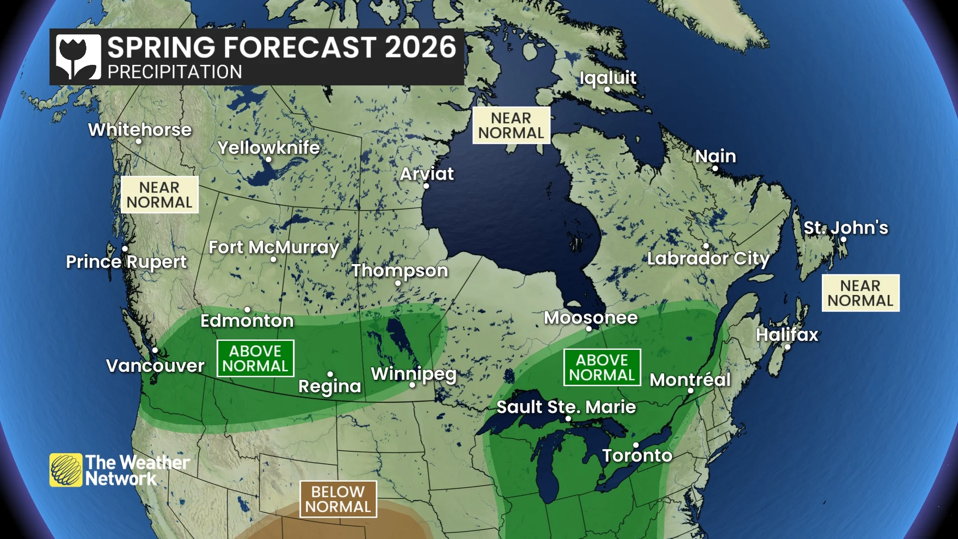
Nationally, temperatures are forecast to sit near or below seasonal norms through March and April. May remains less certain, with the possibility of an early taste of summer in parts of the country. Precipitation levels are expected to be near or above normal into April, though western Canada could trend drier heading toward early summer.
The Weather Network: Spring 2026 Forecast
British Columbia:
British Columbia’s South Coast, including Vancouver and Victoria, largely avoided major winter storms, with intermittent spring-like stretches before late February, when conditions shifted back to typical winter conditions. Temperatures are expected to hover near seasonal levels into early spring, with periodic active weather that could improve alpine snowpack and support a late boost to ski conditions. In other locations, deeper snowpack should sustain strong spring skiing through April. By May, a rapid move to warmer, drier weather could raise localized flood risks during snowmelt.
- Temperature Outlook: Near normal; Below normal north
- Precipitation Outlook: Near normal; Above normal south
The Prairies:
Credit: The Weather Network
The Prairies saw a mid-winter thaw that brought record warmth, but that early hint of spring has reversed, with colder conditions reasserting themselves. Through March and much of April, temperatures are expected to remain below seasonal norms, with shifting weather patterns and additional snowfall.
In Alberta, including Calgary and Edmonton, the cooler stretch may prolong ski season in the Rockies.
Across Saskatchewan and Manitoba, including Saskatoon, Regina and Winnipeg, lingering chill and above-average precipitation could slow the start of fieldwork.
By May, a transition toward warmer, drier weather is forecast, particularly in Alberta, though reduced moisture may increase wildfire concerns heading into summer.
Alberta:
- Temperature Outlook: Below normal; Near normal southwest
- Precipitation Outlook: Above normal south; Near normal north
Saskatchewan:
- Temperature Outlook: Below normal
- Precipitation Outlook: Above normal south and central; Near normal north
Manitoba:
- Temperature Outlook: Below normal; Near normal far north
- Precipitation Outlook: Above normal; Near normal southeast and north
Ontario & Quebec:
Ontario and Quebec are headed for a slow transition out of winter. Colder-than-normal temperatures are expected to dominate through March and much of April, extending ski conditions but delaying the growing season.
While brief mild spells, even early summer-like warmth, may push north from the U.S., they likely won’t last. Above-normal precipitation, including snow and rain in cities such as Toronto, Ottawa, Montreal and Quebec City, could complicate spring planting. May remains uncertain, with signals pointing to either continued cool weather or a rapid warm-up.
Ontario:
- Temperature Outlook: Below normal; Near normal far south
- Precipitation Outlook: Above normal south and east; Near normal northwest
Quebec:
- Temperature Outlook: Near normal; Below normal west; Above normal north
- Precipitation Outlook: Above normal south and west; Near normal east and north
Atlantic Canada:
Atlantic Canada is forecast to see a fairly typical spring, marked by shifting temperatures and an active storm track. March and April should bring near-normal precipitation, with some areas possibly trending wetter. Periods of mild weather will be balanced by cooler, late winter-like stretches, though swings won’t be as sharp as in western and central Canada. In Newfoundland and Labrador, including St. John’s and Corner Brook, similar changeable conditions are expected. A gradual warm-up is likely in May, without a sudden jump to summer.
- Temperature Outlook: Near normal; Above normal Labrador
- Precipitation Outlook: Near normal
Northern Canada:
Northern Canada is expected to see above-normal temperatures across Nunavut, including Iqaluit. Most of the Northwest Territories and Yukon, such as Yellowknife and Whitehorse, should experience near-seasonal conditions, though southeastern Yukon and the southwestern NWT may lean colder. Seasonal averages will climb steadily as spring progresses. Precipitation is forecast to remain near normal overall, with some areas potentially turning drier approaching early summer.
- Temperature Outlook: Above normal Nunavut; Below normal southeast Yukon and southwest NWT; Near normal elsewhere
- Precipitation Outlook: Near normal
The Weather Network advises Canadians to stay informed on daily forecasts as weather and road conditions may rapidly change, underscoring the unpredictable nature of the spring season across the country.


