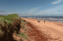
Explore the diverse and picturesque trails of Prince Edward Island, a hiker’s paradise featuring a variety of landscapes, from coastal boardwalks at North Cape to the lush, wooded paths of Dromore.
Credit: Tourism PEI
With trails ranging from easy strolls to challenging hikes, the island caters to all levels of outdoor enthusiasts. Whether it’s the heritage-rich Green Gables or the expansive vistas of the Confederation Trail, each path offers unique scenery and an opportunity to immerse oneself in the natural beauty and tranquillity of this charming Canadian province.
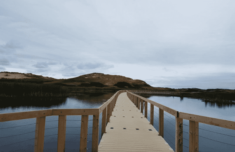
1: North Cape Hiking Trail
Length: 3.5km
Exploring Prince Edward Island’s northern tip can be done at North Cape, a three-and-a-half kilometre trek around the North Cape. The trail is an easy hike along a linear boardwalk following steep cliffs with spectacular views of the ocean below, and the rest of North Cape surrounding you.
There is a lighthouse, a gift shop and a restaurant that complement the trail quite well. There is also a beach that is accessible at low tide. North Cape is a great place to go for an easy hike. Trail Map
2: Dromore Hiking Trails
Length: 14km
The Dromore Hiking Trails are split into six different individual trails offering plenty of choices for distance and scenery, whether you’re looking for a full-day, half-day or short hike. The dense woodland that makes up all six sections of the Dromore Hiking trails offer diverse terrain, some flat, some with steep climbs. All six make for beautiful hikes, though one particular section — the Birding Loop — might be of interest to photographers as it is only 1.3km long. It loops around Pisquid River which is a great spot to look for a variety of birds and admire the scenery while you’re at it. Trail Map
3: Breadalbane Nature Trail
Length: 6.5km
4: Beck Trails
Length: 4.4km (Blue Loop), 0.5km (Green Trail), 4.1km (Red Loop)
The Beck Trails are located off Route 4 on Commercial Road, there are three trails for you to choose from, but you have to hike through trails to get to other trails. It makes for a fantastic overnight hiking trip or an all-day hike. The Red Loop is what you’ll first come across as you enter the trail system. It is well-maintained and has a variety of challenging terrain.
For your hard work, you are rewarded with fantastic scenery. The trail system is multi-use, and there are still mountain bikers braving the trails, so be sure to hike responsibly and keep an eye out for them, too. Trail Map
5: Gulf Shore One Way East, Prince Edward Island National Park
Length: 8.5km one-way
The Gulf Shore Way trail provides a link between Brackley Beach and Dalvay through a vast network of well-maintained trails through woodland, salt marsh and beach dunes.
The Gulf Shore provides smooth asphalt for some of the trail, perfect for those on mountain bikes, and for those who prefer a much sturdier underfoot path when hiking. As you reach the end of the trail, you’ll come upon beautiful seaside scenery.
The length of the trail makes an all-day hike the better choice if you want to complete the trail. It is also a multi-use trail, often used by cyclists, so be sure to keep an eye out for them. Trail Map
6: Robinson’s Island Trail System, Prince Edward Island National Park
Length: 5km
You should definitely allow yourself a full day for this hike, as there are many lookout points along the trail, allowing you to look out onto the sea for wildlife and birds or just admire the seascape.
Robinson’s Island is a fantastic place for a hike due to its diversity of challenging and easy terrain and beautiful landscapes. Trail Map
7: Greenwich Dunes Trail, Greenwich
Length: 4.8km
The Greenwich Dunes are located in Greenwich, not far from the Gulf Shore trails at Dalvay-by-the-Sea. The trails themselves are well-maintained, flat trails with the occasional boardwalk, meandering in between the towering sand dunes of Prince Edward Island’s Gulf Shore.
Some of the most beautiful hiking on the entire island can be found here, as the reeds that surround the meandering boardwalks sway in the gentle ocean breeze. While the seaside to your right is often the focal point of the Greenwich Dunes, one should also look inland for some spectacular views. Trail Map
8: Forest Hill Trail, Points East
Length: 7.8km
The Forest Hill Trail is located five miles north of Bridgetown in Kings County, looping through a vast woodland (with many other trails branching off it) over gently rolling terrain.
Most of the woodland area is on a wetland, with deep swales, including two large pond areas. There are two accessible trailheads: one at a parking lot on Route 339, known as the Corral trailhead, and another further up Route 339 at Whitlock’s Pond — Whitlock’s Pond also has a forty-foot lookout tower overlooking the entire area. This would be a great spot to get a great picture!
That aside, the trail is well-maintained and almost entirely in a wooded area. The area is also heavily used by horse riders, so be mindful of their presence at all times. Trail Map
9: Balsam Hollow, Green Gables Heritage Place
Length: 0.8km
This, the shortest of trails on our list is also the place where you’ll find the infamous Anne of Green Gables Heritage House. The primary setting of Maud E. Montgomery’s famous book, Balsam Hollow and Green Gables Heritage Home makes for a fantastic day out in PEI for all the family.
If you wish to truly experience Island heritage, then Green Gables is the perfect place for you to start. The Balsam Hollow hiking trail is an added bonus. Being just 0.8km in length, it can easily be completed in a matter of half an hour or so, as it is on every level and unchallenging terrain.
Though the beauty of Balsam Hollow will pop out as you walk the gravel trail, it loops around a small river that runs alongside the Green Gables House, and there are places to stop and sit and admire the beauty of your surroundings. Trail Map
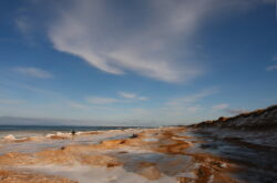
10: Cavendish Dunelands, Cavendish
Length: 2.3km one-way
The Cavendish Dunelands trail provides the hiker with a fantastic view of Cavendish Beach on the north shore of the Island. Despite being only 2.3km in length, the trail itself, though again, by the seaside, is not lost for natural beauty.
As the low reeds sway in the wind, the sparsity of trees really stands out, making for some fantastic landscape photos.
The terrain is mostly on floating boardwalks, thereby making the trek very easy indeed. This should be a 2-3 hour hike, perfect for a leisurely afternoon on the Island. Trail Map
11: Gairloch Trail, Lot 60
Length: 7km
The Gairloch Trail is a loop trail spanning about 7km in a wooded area of around 1500 acres of diverse woodland with many different trails running throughout.
The terrain is diverse, from steep climbs up slippery wood-lined hills to bridges across rivers and streams, and there are several difficult sections scattered along the 7km route. It’s ecologically diverse too, with white spruce thickets and pines being found in more open areas — beautiful in the fall! It’s also home to many furry creatures such as foxes, coyotes, squirrels, hares and skunks.
If you’re hoping to spot them, you’ll need to either alone or in a very small group so as not to frighten them off. The dense woodland of the Gairloch Trail offers beauty and diversity in spades. Perfect for an afternoon, or full-day hike. Trail Map
12: Strathgartney Trail, Strathgartney Provincial Park
Length: 5km
Strathgartney Provincial Park is the oldest provincial park in Prince Edward Island, established in 1956. Not long after that, the Strathgartney Trail was built and has morphed over time from multiple developments being conducted by the Government of PEI. The park itself has a campground where you can park up before you hike. It has multiple amenities, even offering kayaks and canoes and a day-paddle area.
The hiking in the park on the Strathgartney Trail is gorgeous, with many birches littering the trail and some interesting sights along the trail, such as the sun dancing in the woods throughout the day, casting beautiful shadows. The trail itself can be difficult with hikers and mountain bikers sharing a forest floor — be on the lookout for them!
The trail is well maintained, although mainly comprised of the dirt of the forest floor and several footbridges for crossing the watery parts. At only 5km in length, the trail makes for a great afternoon hike in PEI’s oldest Provincial Park. Trail Map
13: Bonshaw Trails, Bonshaw Provincial Park
Length: ~25km (Three different trails of varying lengths and degrees of difficulty)
Bonshaw Provincial Park is home to multiple different trails of varying lengths, covering 25km cumulatively. The trails themselves are diversely difficult, from walking trails to challenging, steep climbs. There are three types of trails: GREEN, BLUE and BLACK all denote different lengths and difficulties.
The GREEN route is the easiest, with gentle climbs and easily avoidable obstacles, a pleasant and enjoyable. The BLUE route is slightly more challenging with steeper slopes and narrower trails.
The BLACK route is only passable by hikers and is the most difficult and longest trail of the lot. Steep climbs, sometimes loose ground and a variety of obstacles. Each trail on the map is marked with a corresponding colour denoting its difficulty, but there is a multitude of trails to choose from.
Hiking in Bonshaw is a beautiful way to spend a fall day; regardless of which trail you pick, you’re sure to find beauty everywhere. Trail Map
14: Farmscapes Trail, Port-la-Joye/Fort Amherst National Historic Site
Length: 3km
The Farmscapes Trail at Fort Amherst is a throwback to the old 18th and 19th century Acadian and then British farmland which was cultivated on the island centuries ago.
The trail itself is only three kilometres long and a relatively easy hike, with only slight inclines — but the views offered from the trail itself are serene. Overlooking the Island and Fort Amherst, a Canadian National Historic Site and site of one of the key defences of the British military during the 18th century.
The site itself is home to many trails, but the Farmscapes trail highlights the natural beauty of the Island best, as cannon fire is no longer present, and now arable farmland makes up the Fort. Fort Amherst hiking trails are a wonderful way to spend the day admiring the present while in touch with the past. Trail Map
15: The Confederation Trail, Whole Island
Length: 435km
Perhaps the crown jewel of Prince Edward Island’s tourism board is its Confederation Trail.
Built on an old rail trail, the Confederation Trail is comprised of many sections and stretches across the entire island from east to west. If you choose to hike it, you’ll need at least a week, perhaps two to complete the whole trail. Alternatively, you could simply choose to hike sections of the trail, which you can decide for yourselves from the trail map below.
There perhaps is no greater hike to experience the full beauty of Prince Edward Island than all or parts of the Confederation Trail. It winds through the Island’s diverse landscape with the tree leaves of yellow and red and orange popping out along the way, offering a glorious motif for an island steeped with natural beauty. If you hike any trail on PEI, the Confederation Trail must be on your list. Trail Map
Hiking in Prince Edward Island is a challenging and unique experience. Whether you’re hiking near the sea or further inland, the natural beauty of the Island never leaves you. If you’re looking for a place to hike in Eastern Canada, then the Prince Edward Islands is one of the most beautiful and charismatic provinces in the region.
Useful resources:
Island Trails – Check trail status


This is Stanhope Cottages Jenny, we want to package with you, please send your information and policy to us.
Thank you.
Jenny
Strathgarney is Not an overnight camping area anymore. They fire pits etc are still there but can be used during the day pnly.