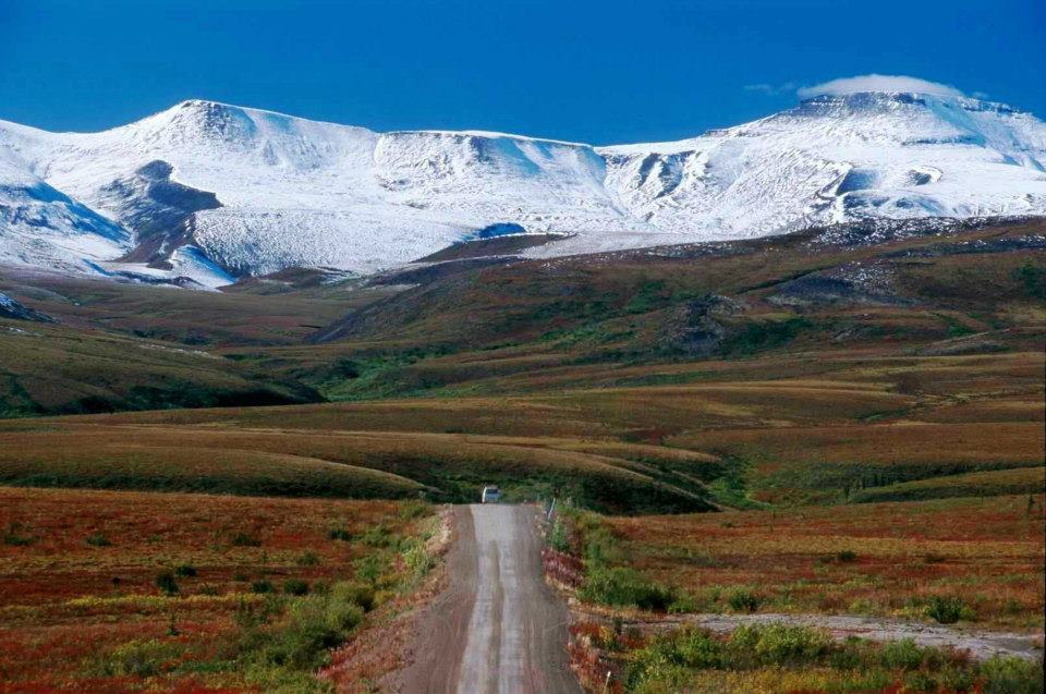
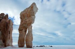
Credit: Dempster Highway
The Dempster Highway, begun in 1959 as Yukon Territorial Road No. 11, was first officially opened in 1979 and is Canada’s first all-weather road to cross the Arctic Circle. Today, it is considered one of the world’s most unique driving experiences. Not only is it home to an array wildlife, but it also contains some of the most unmatched tundra landscape in all the world. This summer, plan a road trip like none other – Drive the Dempster.
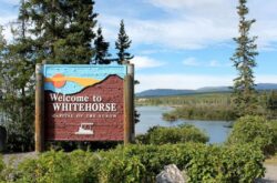
Whitehorse → Dawson → Inuvik Road Trip
The following itinerary is for the greatest ease of use. Depending on your driving style, your road trip plans, and your vehicle, you may want to drive as little as three hours a day, or as much as twelve. As well, you might want to spend time gambling in Dawson or hiking through the tombstones. For that reason, I’ve created an easily adaptable itinerary.
The Dempster Highway drive is divided into three parts:
- 1st, Whitehorse to Dawson, a 530km drive that can be completed in approximately 7 hours;
- 2nd, Dawson to Eagle Plains, a 405km drive that will take approximately 9.5 hours;
- and 3rd, Eagle Plains to Inuvik, a 365km drive that will take approximately 7 hours.
Of course, these times will change depending on road conditions, speed, and preference.
Under each of these three drives, We’ve highlighted places of interest, possible detours, and any lodging and gas available. Finally, We’ve included the distance between each place of interest so that you can decide how much time you can spend, and whether or not you’ll need to fuel up before the next stop.
Use this guide to plan where you will stop, and how long you want your road trip to last. Pack up and get on with it – this is going to be the trip of a lifetime!
You may like:
- Summer Trip to Yukon – 3 Day Itinerary
- 25 Best Places and Sites to Visit in Yukon
- 15 of the Best Places to Visit in the Northwest Territories
Whitehorse → Dawson (530km – 7 hours)
Ruby Range Adventure Ltd.
North Klondike Highway
After leaving Whitehorse you will drive 14.5 kilometres from the city centre to the turn-off for the historic North Klondike Highway. This highway, from Fox Lake to Dawson, is also known as The Fire Belt. Over the past 50 years, six major human and natural-caused fires have transformed the boreal forest. Because of this road trippers have the unique opportunity to witness the changes that accompany each stage of regrowth. Keep an eye out for interpretive pull offs and displays between Fox Lake and Dawson City. For more information on the fire belt visit website.
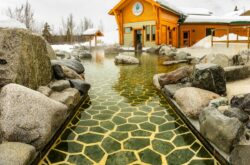
Takhini Hot Springs Road (6km from Alaska Highway)
Credit:
Arctic Range Adventure
If you want to start your trip on the road, this is a great ground zero. Rent a campsite or room at the hostel at Takhini Hot Pools and enjoy a soak the night before you get started, pick up a hot coffee and breakfast at Bean North Coffee Roasting, and take a guided tour through the Yukon Wildlife Preserve to learn about the animals you’ll be looking for on the road! Finally, stop in at Takhini gas to fill up the tank, pick up your snacks, and check current road conditions.
– Takhini Hot Pools (9km from Klondike Highway)
Visit Yukon’s only natural hot springs collected in outdoor pools in the Yukon wilderness. With two pools, one hotter and one cooler, you can set your comfort level accordingly. If weather permits you can also rest along the sides of the pools in the complimentary pool chairs.
If you’re looking for more than a soak, take advantage of the other amenities here:
- Go for a hike in the Yukon wilderness – the Pools are surrounded by numerous hiking trails of varying difficulty
- Have a campfire – There is an attached day and overnight use campground, so bring the marshmallows and sit around the campfire while the day is young!
- Escape – Takhini Hot Pools is happy to also be home to the Yukon Escape Games. Choose from one of two escape rooms: A Klondike themed room for beginners or a kidnapping adventure for more experienced escapers! Check out their website for more information
Website
– Bean North Coffee Roasting (8.5 km from Klondike Highway)
Who doesn’t want a fresh cup of locally roasted coffee and a homemade muffin to start the day? Bean North Coffee Roasting is off the normal tourist track, so you’ll really feel like a local! Check out their roasted coffees, gourmet hot and cold beverages, homemade baked goods and sandwiches, and wide collection of eclectic locals arts. For more information go to website.
– Yukon Wildlife Preserve (8km from Klondike Highway)
Credit: Yukon Wildlife Preserve
With all of the driving, you’re about to do, you’ll be seeing a lot of Yukon wildlife. Brush up on your research with a 5km guided bus tour around the Yukon Wildlife Preserve. Here you’ll see woodland caribou, Canada lynx, Rocky Mountain elk, mountain goats, Alaska Yukon moose, mule deer, muskoxen, wood bison, two varieties of thin horn sheep (Dall’s sheep and stone sheep), and red and arctic foxes. With this premeditative experience, you’ll know what to look out for on the road! For more information visit website.
– Takhini Gas (at Klondike highway & Takhini Hot Springs Road)
This classic gas station/restaurant is located in an old log cabin on the corner of Takhini Hot Springs Road and the Klondike Highway. If you’re a little less hungry and just looking for a quick bite on the road, their small attached café will be perfect. You can get ready-made bison sausage rolls, burgers, hot soup, and meat pies that will be warmed up upon order, or saved for further down the road. This is the last gas station for over 80km so make sure you’re ready to hit the road! There is no website or Facebook page for this local gem, but a quick Google search should do the trick.
Lake Laberge (31km from Takhini Gas)
Lake Laberge reached notoriety through Robert Service’s poem “The Cremation of Sam McGee”, wherein he writes:
There are strange things done in the midnight sun
By then men who moil for gold;
The Arctic trails have their secret tales
That would make your blood run cold;
But the queerest they ever did see
Was the night on the marge of Lake Laberge
I cremated Sam McGee
Not to worry; your blood won’t be running cold on this trip! You can visit the campground for a midday picnic while you admire one of Yukon’s biggest lakes. There is also a Bed and Breakfast (The Lodge at Lake Laberge) on the lake, but at the time of this writing, it is closed until further notice. Check their website to see current conditions.
Website
Fox Lake – Klondike Bed & Breakfast (16.5km from The Lodge at Lake Laberge)
Fox Lake is a favourite family spot because of its calm water, family-friendly campground, and deep bottom, excellent for fishing. At the very start of the lake, you will see signs for the Klondike Bed and Breakfast. You can rent traditional homemade wooden cabins overlooking Fox Lake year-round, equipped with a fireplace and kitchen. As well, you can either cook for yourself in your cabin or request homemade meals from the friendly staff. For further information and current reviews go to website.
Cinnamon Bus at Braeburn Lodge (43km from Klondike Bed & Breakfast)
Ask any Yukoner where you have to stop on your way north and the answer will always be, unequivocally Braeburn for a cinnamon bun. The best buns in the Yukon are here, and they’re bigger than your head! The Lodge also sells sandwiches (equally massive), gas, and lodging. This is also one of the stops of the Yukon Quest, and they have the memorabilia to prove it! Finally, you’ll want to check current road conditions with the staff here, as they’re always in the know with drivers coming from both directions. Check out their Facebook page for more information.
Website
Village of Carmacks (75km from Braeburn Lodge)
This small village of approximately 490 people is home to the Little Salmon/Carmacks First Nations. Historically, this little village was a riverboat refueling station and a major stop on the Overland trail linking Whitehorse and Dawson. Here, you’ll find a small restaurant, a hotel, a visitors’ centre, and a gas station. Depending on how economical your vehicle is on fuel, you may want to top up the tank here; it’s going to be over 100km until the next service station. You’ll want to stop at the pull out on the highway to get a spectacular view of the Five Finger Rapids for a photographic portfolio!
Website
– Hotel Carmacks & Tachun General Store
Here you will find a typical small-town one-stop shop. You can rent a simple room for the night at the hotel, pick up some groceries and snacks at the general store, or just fill up your gas tank at the service station. For a complete list of services visit website.
– Tagé Cho Hudän Interpretive Centre
The Tagé Cho Hudän Interpretive Centre is the Carmacks Visitors’ Centre, focusing on the past and present culture of the Northern Tutchone First Nations. This unique centre has one-of-a kind interpretive displays including a mammoth snare diorama, a stone and bone tools collection, and a moose skin boat. For hours and contact info go to website.
– Five Finger Rapids
These incredible rapids were a major obstacle for prospectors making their way from Bennet Lake to Dawson City during the 1898 Klondike Gold Rush. Today, they are little more than a wonderful photo opportunity for travelers making their way along the Klondike Highway. There is a convenient pull off with parking room and interpretive signage just after Carmacks. For more information on the history of the Five Finger Rapids, go to website.
https://www.instagram.com/p/BXn3AvXje7G/?tagged=fivefingerrapids
Pelly Crossing (104km from Carmacks)
The next community you will come through is Pelly Crossing, a small 300 person population of Selkirk First Nation. With such a small population, services are scarce – There is a seasonal cultural centre and a grocery store/gas station. To view the Pelly Crossing community profile, go to website.
https://www.instagram.com/p/BREpOSkh3Jl/?tagged=pellycrossing
– Selkirk Groceries
Here you can pick up some groceries and snacks to fuel you for the rest of the drive, as well as some lotto tickets if you’re feeling lucky! There is a service station here, so be sure to check your oil, fill your tires, and top up your gas tank. The next gas station is in 70km at Stewart Crossing, and depending on the time you may or may not have access to the store to pick up supplies.
Website
– Big Jonathon House
Big Jonathan House is a replica of Fort Selkirk’s Big Jonathan house from the fur-trade era. Now, it is a cultural centre for the Selkirk First Nations’, and displayed an impressive collection of works by local artists, locally made traditional wares, and beaded clothing, some of which are for sale. To add to your knowledge, there is also a “Voices of the Past” education visitors on the area and its people. For seasonal hours visit website.
Stewart Crossing (70 km from Pelly Crossing)
Website
Immediately after Stewart Crossing you will come to a fork in the road where you can turn right and take a detour to Mayo, or turn left and be on your way to the Dempster!
Mayo (50 km from Stewart Crossing)
The Village of Mayo, self-proclaimed Heart of the Yukon – was established in 1903 and is the traditional territory of the Na-Cho Nyäk Dun First Nation. There is an approximate population of 450. Historically, this was a significant service centre for silver, zinc, and lead-ore mining. Mayo continues to be a significant centre for mining activity with vibrant community culture. Because of its position as a starting point for many mining locales, Mayo has more services than other communities of a similar population.
Website
Some of the highlights include:
– Binet House Museum & Interpretive Centre
This museum and interpretive centre houses a large collection of photographs of past and present Mayo residents and local Na-Cho Nyäk Dun First Nation, all within a restored heritage building. As well, there is a three-dimensional map of the region, and multiple interpretive displays. For current hours of operation visit website.
– Bedrock Motel
Enjoy a comfortable private room at the Bedrock Motel while you set aside a day or two to enjoy exploring Mayo and the surrounding mining areas. For more information on the motel visit website.
Dempster Highway Turn Off (140 km from Stewart Crossing)
This is the beginning of the Dempster Highway. However, the next campsite is 70km away and the next gas station is not until Eagle Plains, 365km of rough highway away. If you left Whitehorse this morning, it is strongly advised you spend the night in Dawson and begin the Dempster Highway tomorrow.
Dawson City (180km from Stewart Crossing)
Until 1952, Dawson City was the capital of the Yukon. It called itself the Paris of the North during the 1898 Klondike Gold Rush and was without a doubt the centre of activity for gold mining. Today, it is a historian’s paradise with its pioneer-era building fronts, comical gold rush-themed entertainment, and true-to-tale gold tours. Dawson has far too much to offer to cite here, so check out our Dawson itineraries if you plan to spend a few days here. You can also visit their official website.
Dawson → Eagle Plains (405km – 9.5 hours)
Dempster Highway Start (40 km from Dawson)
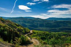
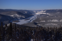
This is where the real adventure starts. While the Klondike Highway was dotted with communities, roadside lodges, and interpretive displays, you’ve now entered the real outback. It is up to you to decide where to stop for photographs. Take your time and hike into the fields that look so inviting, and explore the lakes closer than from the car window. But don’t forget your bear spray! With reduced traffic and fewer inhabitants, you are that much more likely to see Canada’s most massive wildlife. You are in their territory now, and you must be wary.
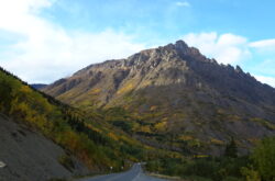
Tombstone Territorial Park (50km from Dempster Highway Start)
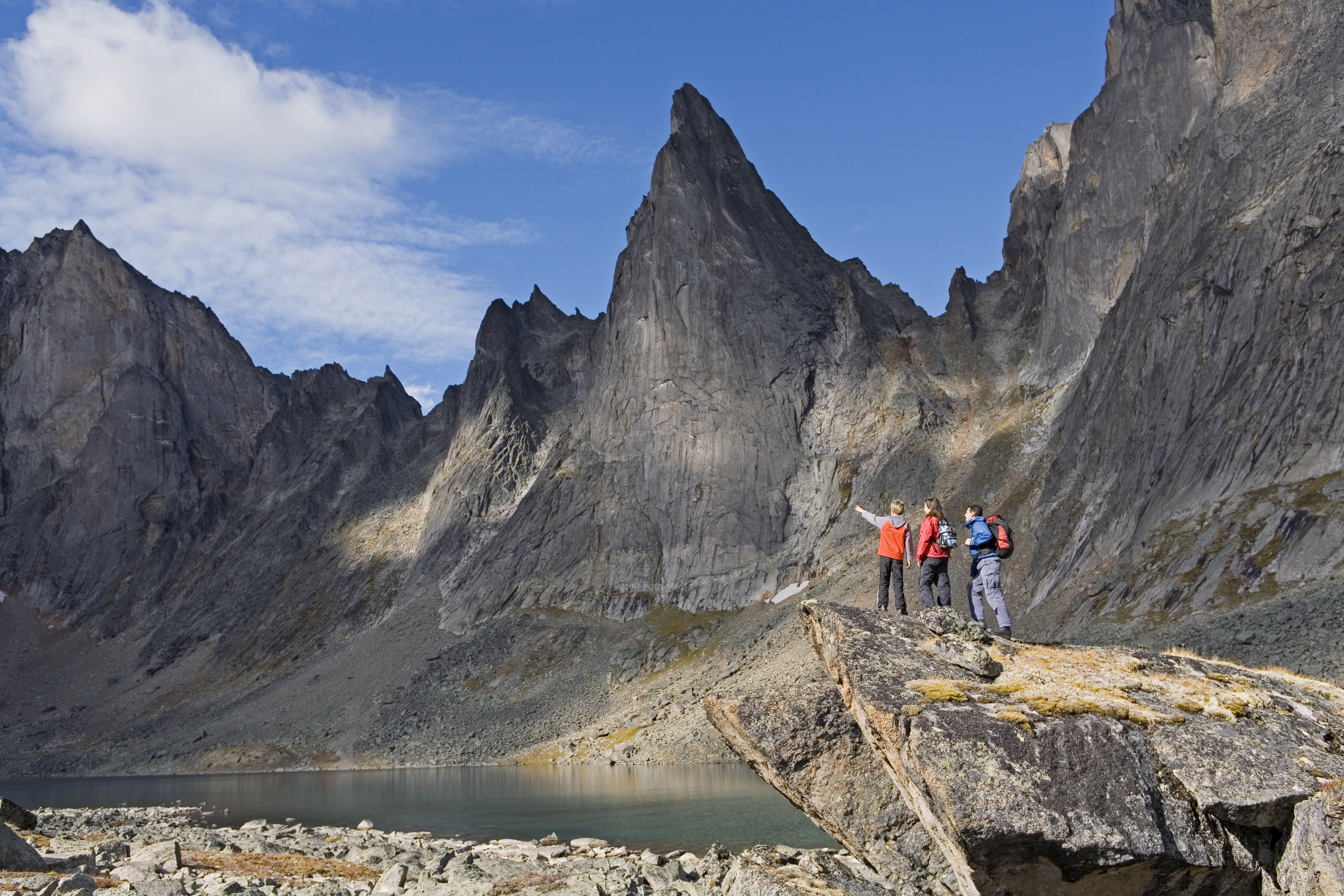
Government of Yukon / Fritz Mueller
Located in Tr’ondëk Hwëch’in land approximately 50km into the Dempster Highway, Tombstone Territorial Park is 2200 square kilometres of protected wilderness. Take time to enjoy world-renowned hiking and camping through the rugged peaks, permafrost landforms, and abundant wildlife territory. You can forage the land for berries, spruce tips, and wild herbs while keeping an eye out for the abundant wildlife that makes this park their home. Some of the most prominent features to mark on your ‘to-photograph’ list are Mount Monolith, Tombstone Mountain, and Glissade Pass. For more information visit website.
Instagram
Tombstone Campground (70 km from Dempster Highway Start)
While this is the primary campground, you can also make reservations to camp at Grizzly, Divide, and Talus Lakes. These backcountry campgrounds offer tent pads, an outhouse, and a small cooking platform. You must reserve sites at these campgrounds ahead of time. If you want to experience some of the most incredible hiking, wildlife viewing, and photography opportunities this side of the Ecuador, you should absolutely pack a tent and spend a day or two exploring this magnificent Territorial Park. If tenting is not your forte, there are still plenty of short hikes or highway pull offs where you can take in this see-it-once-in-a-lifetime landscape.
Instagram
Tombstone Range Viewpoint (75km from Dempster Highway Start)
As mentioned above, if you won’t be camping or hiking through Tombstone Territorial Park, all is not lost. The Tombstone Range Viewpoint is a highway pulloff where you can see an incredible view of the mountain range. There are also interpretive signs here describing the history, geology, and cultural significance of the area. Take out your picnic goods and spend some time basking in one of the most extraordinary places in the world.
Engineer Creek Campground (125 km from Tombstone Campground)
Engineer Creek Campground is serviced campground with tent sites, firewood, and outhouses. You must bring your own toilet paper and carry out your garbage. Again, this is a beautiful campsite if you plan on hiking and fishing on your journey. If the Tombstone Campgrounds are full, you can choose to pitch your tent here and drive back to the Park to hike during the day. However, if you prefer a motel or full services for you RV or Motorhome, its best to continue on to Eagle Plains today.
Website
Eagle Plains (170km from Engineer Creek Campground)
Though 170km doesn’t seem to be far, expect this jaunt to take close to four hours or more, depending on road conditions. In remote areas like this, you definitely do not want to take chances driving too fast – services are few and far between and accidents can be fatal. Take your time, and plan your trip accordingly.
Eagle Plains is not a community, but an expanse of rolling hills between the Ogilvie and Richardson Mountain ranges. Sitting atop permafrost, the ground is covered in mosses, lichens, and shrubs that take on a healthy green color in Spring (June) and a fiery red in Fall (Late August).
Website
– Eagle Plains Hotel
The Eagle Plains Hotel and Service Station is a one-stop shop in a barren land. You will be happy to find a gift shop, licensed dining room, store, vehicle service station, laundry, motel, lounge, and full camping facilities. Here you should be find anything you’ve forgotten or didn’t know you needed! Talk to the friendly staff about current road conditions and recent animal sightings. If you left Dawson this morning and have driven the Dempster all day, you’ll be happy to sit back with a cold one and talk to the other roadtrippers.
Website
Eagle Plains → Inuvik (365km – 7 hours)
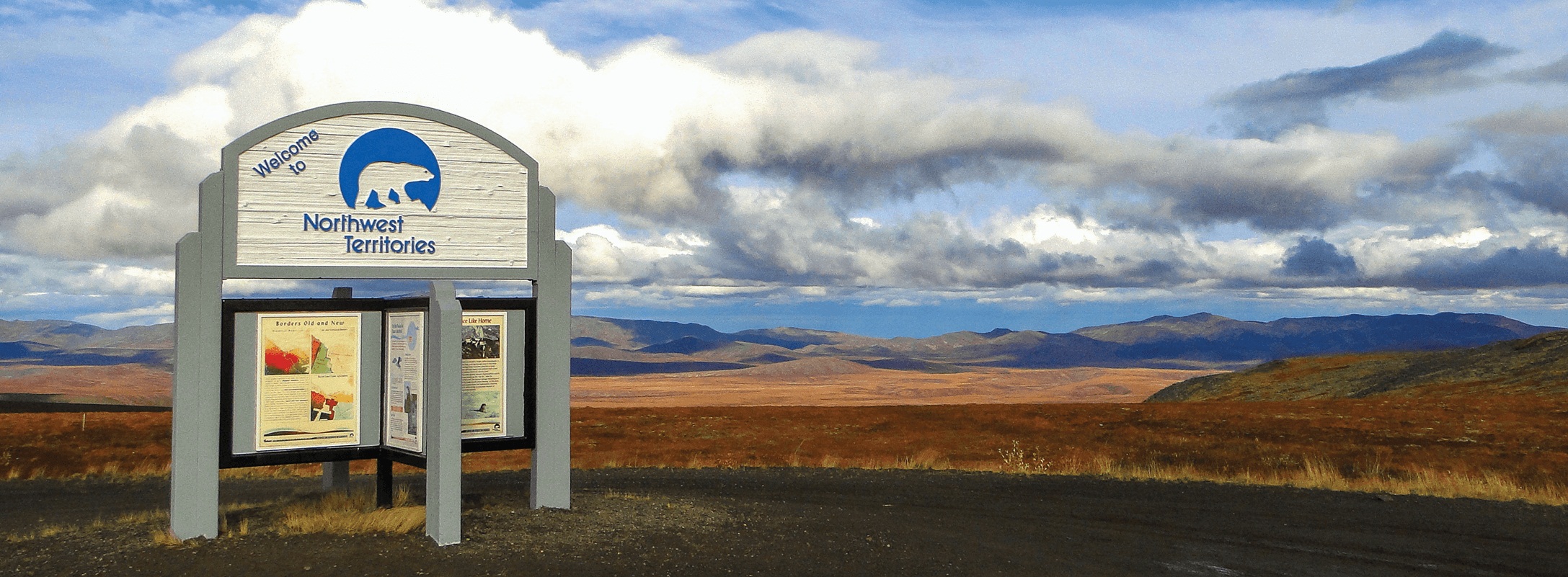
NWT Border (95km from Eagle Plains Hotel)
Credit: Dempster Highway
It might be hard to believe, but with all this driving you haven’t even left the Yukon Territory! Finally, you’ll cross the imaginary line, and real time zone, into NWT. Don’t forget to set your clocks ahead an hour and get ready for the last leg of the adventure!
Fort McPherson Hamlet (86km from NWT Border)
The Hamlet of Fort McPherson is the first populated area you will find on the Dempster Highway, excluding Eagle Plains which is populated with Hotel staff and travellers. The Hamlet has a year-round population of approximately 900, 80% of which is of Gwich’in descent. Here you will find plenty of services, culture, and history. Take some time to speak to the locals and learn about this community that was established as a trading post in 1849 by explorer John Bell.
Website
– Nitainlaii Territorial Park
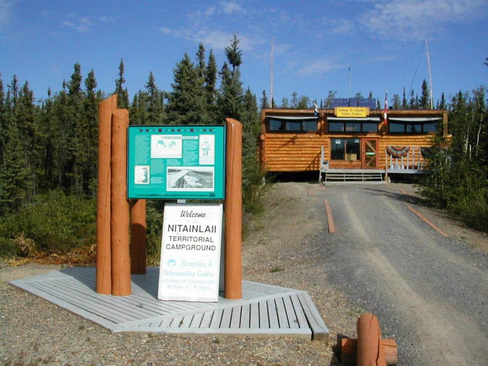
Credit: NWT Parks
This park is situated on a cliff overlooking the Peel River, so it certainly continues the impressive views trend. It features 23 non-powered campsites, washrooms, drinking water, a kitchen shelter, and a picnic area.
Website
– Peel River Inn
Here you will find the most modern guest rooms in Western NWT. If you’ve had enough of chilly tents and outdoor showers, take advantage of the modern conveniences at the Peel River Inn: private bathrooms, coffee service, cable television, radio, internet, private rooms, and laundry services. For more information on the Peel River Inn visit website.
– The Lost Patrol Graves
The North has witnessed a number of tragedies, as the land is hard and the winter is mean. You can learn about one such tragedy in Fort McPherson at the Lost Patrol Graves next to St. Matthew’s Anglican Church. These graves stand as a tribute to Inspector Francis Fitzgerald and his three constables who lost their lives after a series of missteps in the early months of 1911. For a more detailed history go to website.
– Fort McPherson Tent & Canvas
Website
Tsiigehtchic (60km from Fort McPherson)
This dry community of approximately 130 Dene people is the ancestral territory of the Gwichya Gwinch’in. Permanent settlement here began in 1868 with the establishment of a Catholic Mission, and in 1870s a Hudson Bay Company trading post. Tsiigehtchic means “Mouth of the iron river” which is fitting considering it is only accessible by ferry, and sits at the confluence of the Mackenzie and Arctic Red Rivers. This tiny town relies heavily on traditional fishing, hunting, and trapping, and is definitely worth a few hours on your travels. There is a Community Centre, store, service station, bed and breakfast, diner, and small hotel. These services are not available year round and have very little online-presence. Plan to spend at least part of your afternoon exploring this tiny northern town.
Website
Instagram
Inuvik (129km from Tsiigehtchic)
This is your final jaunt! In less than two and a half hours you will have driven both the Klondike and the Dempster highways – a feat few can brag of. After crossing the Mackenzie River you will travel steadily northeast towards the Arctic Circle. Inuvik is located 2 degrees above the Arctic Circle and is the homeland of the Inuvialuit and Gwich’in peoples, with an approximate population of 3200 people. It is truly a wilderness city, located between the treeless tundra and northern boreal forest, on the Mackenzie Delta and close to the Arctic Ocean. This is a land of plenty in an unmanned expanse, and it has so much to offer. For a complete list of services, must-see sights, and community highlights, visit the official Inuvik website.
You’ve done it! You’ve seen unchartered lands that have taken many before you. Twelve hundred and ninety-nine kilometres later you faced the fire belt and discovered the Dempster. With surely a few scrapes, some souvenirs, hundreds of photographs, countless memories and even more mosquito bites you can say you’ve seen the top of the world. Take your time in Inuvik, return to some of the spots you had to skip on your way up as you make your way back home. It may be with a heavy heart that you say goodbye to the road. Not to worry, there are plenty more highways to conquer.
I’m planning my Dempster Hwy trip for summer 2021 and I found the information given very useful.
Thank you