The Red Rock Parkway is an incredible drive filled with changing scenery.
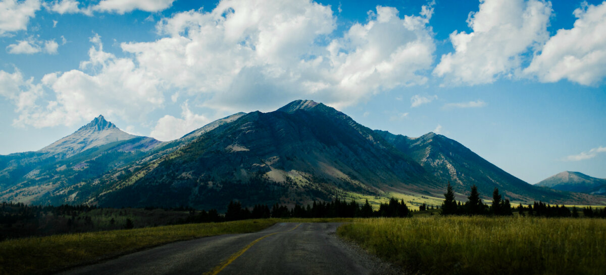
The scenery changes almost every minute, too. The narrow highway leads from Waterton into the Blakiston Valley between several large peaks. The road begins with large fields, which eventually thicken into a forest. It is a drive that reveals the prairie turning to foothills, turning into mountains. While the drive is beautiful, it is the end of the Red Rock Parkway, which attracts thousands of visitors each year.
About the Red Rock Parkway
There are a few notable scenic drives and parkways within Waterton Lakes National Park: the Akamina Parkway, the Chief Mountain Highway, or the Bison Paddock Loop Road (best for wildlife viewing). And as with all Alberta’s National Parks, even simply the entrances and park gate areas are breathtaking. When it comes to the Red Rock Parkway specifically, there are important things to know before planning your trip.
Previously, this highway was completely closed to motor vehicle traffic. Today, the highway is open to motor vehicles from May 1-October 31. It is only 15km of road, but you will want to plan at least half a day to see all the Parkway’s sights.
The Red Rock Canyon is not the only attraction along this route. After the highway opens to vehicles in the spring, the surrounding fields and hills are in full wildflower bloom. And just before it closes in the fall, the scenery includes vast forests of bright fall colours. The Red Rock Parkway has numerous places to pull over, read interpretive plaques, or start a hike.
The Parkway is named for the Red Rock Canyon, which is a bit of a surprise at the end of the road. The road ends at a large parking lot, visitor’s centre, and picnic area. But it isn’t until you cross the bridge over the canyon that you notice why the area gets its literal name.
The Red Rock Canyon stands out in the scenery with high contrast between the bright green foliage, the blue water, and the red rocks. While at the Canyon, take advantage of the scenic picnic areas, or one of many hiking trails.
Top Four Hikes Near Red Rock Canyon
Red Rock Canyon Loop
This is the main trail at the canyon named after thick, sedimentary beds of red argillite rock. Learn all about the Red Rock Canyon on the short 0.7km interpretive loop. The paved trail crosses the canyon on a bridge from the parking lot, and closely follows the canyon’s edge. Even if you are here for a longer hike, take the loop as a quick warm-up, or save it for the end. The Red Rock Canyon is also the beginning of several other, much longer, hiking trails.
Trail length: 0.7km out-and-back
Blakiston Falls
This rather haunting trail is short and simple as well, with a large payoff at the end of the trail. The forest shows the devastation of a 2017 wildfire that swept through Waterton NP. However, some areas show the forest coming back to life with regrowth. After heading through the forest, the trail ends at viewing platforms which overlook Blakiston Falls. The raging waterfall drops down a few rock faces before hitting the creek bed and is accessible via two different platforms.
2.4km out-and-back, starting from Red Rock Canyon lower parking lot.
Snowshoe Trail to Goat Lake
For those interested in a more challenging hike, the Snowshoe Trail has a few options. The hike on the Snowshoe Trail to Goat Lake and back gives hikers an excellent reward and place to head for a peaceful mid-hike picnic. After the trail forks and becomes the Goat Lake Trail, there is a sharp climb up to the water. The whole hike has about 630m in elevation gain. Along the climb are great views of the Blakiston Valley.
Trail length : 14km out-and-back from Red Rock Canyon upper parking lot
North Crandell Lake
This hiking trailhead will pop up before you hit the Red Rock Canyon on the Parkway and departs from the Crandell Mountain Lodge. The trail will lead through more of the devastation from the 2017 wildfire, with bursts of green regrowth visible everywhere. There is a steady and gradual climb up to the lake, but you’ll only gain ~160 m in elevation- so it isn’t too big of a challenge for the right hikers.
Trail length: 5.1km out-and-back

Plan Your Trip – Red Rock Canyon/Red Rock Parkway
What: The Red Rock Parkway in Waterton traverses 15 km through the scenic Blakiston Valley, ending at the vibrant Red Rock Canyon. This journey showcases the stunning intersection of prairie and mountain landscapes, offering travellers majestic views, notably of Mt. Blakiston, the park’s highest peak.
Location and how to get there: Follow the Red Rock Parkway from Waterton until the end to reach the Red Rock Canyon. (Directions)
Best time to go: May 1-October 31 (Red Rock Parkway is closed to vehicles in the off-season)
Cost: Parks Canada Entrance fee
Adult: $12.25
Senior: $10.75
Youth: free
Family/Group: $24.50
For more information:


