Alberta is one of the perfect provinces for travelling, especially if you are looking for a pretty drive to keep you entertained. Of course, driving through the province invites you to discover and enjoy some spectacular scenery, such as the magnificent Rocky Mountains, the beautiful rolling foothills, and the wide-open expanses of grain-planted fields and prairies.
Wildlife abounds, as you can generally see deer, elk, moose, bears, foxes, and coyotes quite commonly along roadsides and in fields. Keep your eyes out for the stunning golden eagles or hawks that can sometimes be seen perched on fenceposts, or pretty songbirds darting amongst trees, among many more that frequent the different areas.
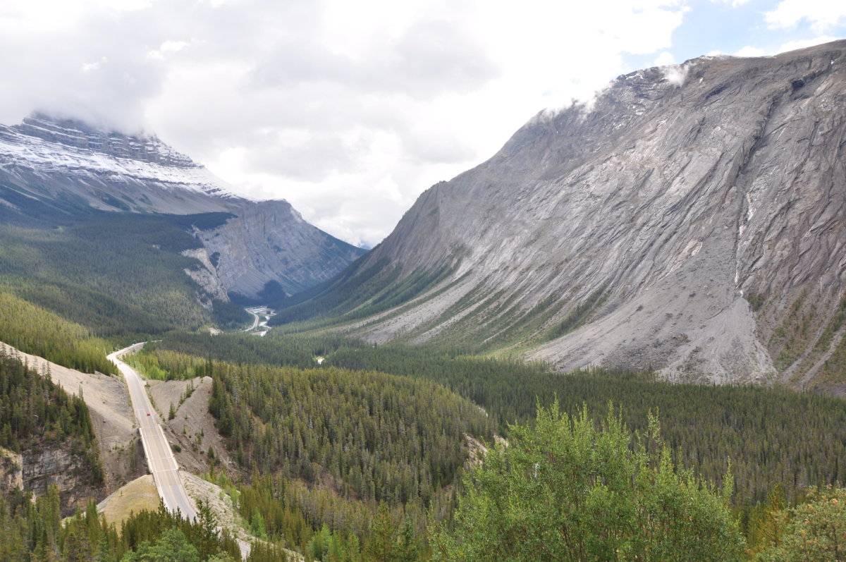
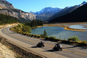
1. Icefields Parkway
We will start off our drive list with the iconic Parkway, which stretches through some of the most spectacular mountain scenery between the town of Lake Louise and the town of Jasper.
Travelling through both Banff National Park and Jasper National Park, this twisty drive will test not only your driving skills but also your ability to keep your eyes on the road!
Due to the amazing scenic points, there are plenty of places to stop, get out of your vehicle and take pictures, along with plenty of opportunities to enjoy a short hike or a picnic.
Drive Distance: 233 kms (Town of Lake Louise to the town of Jasper)
2. David Thompson Highway
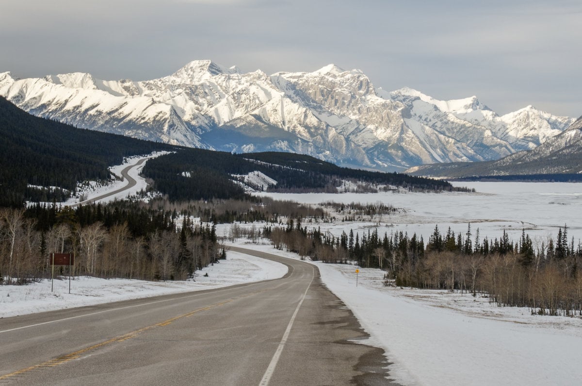
Credit: Jeff Wallace/Flickr
318 km Highway 11 or David Thompson Highway takes you from Nevis to Highway 93/Icefields Parkway at Saskatchewan River Crossing.
Travel through Red Deer, Sylvan Lake, the lovely town of Rocky Mountain House, to a junction of the Icefields Parkway, and it is a great alternative to get you from Red Deer or Calgary up to Jasper without travelling on the busy major roads.
Starting from the rolling prairie hills and making your way through spectacular scenery to the alpine vistas of the Rockies, as you travel along this route, you will be following the steps of the explorer whom the highway is named after. This historic path features amazing views and gives you the opportunity to pass by Abraham Lake, Nordegg, and travel alongside the North Saskatchewan River.
Drive Distance: 178 kms (from Rocky Mountain House) OR 260 kms (from Red Deer)
Drive Time: 1 hour 50 minutes OR 3 Hours (no stops)
3. Kananaskis Trail
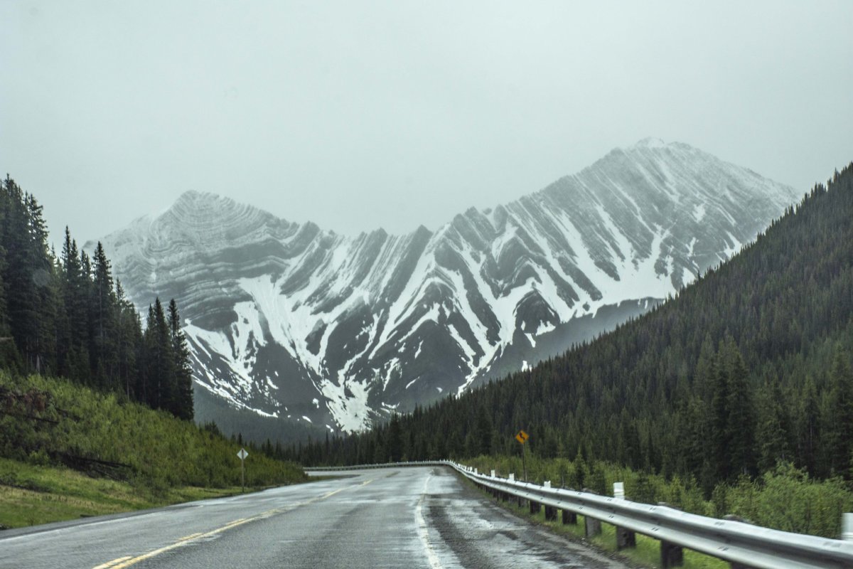
Credit: Jan Mosimann/Flickr
As the name suggests, this highway takes you through Kananaskis Country, through some of the best of the Alberta wilderness, with fewer vehicles than you would see on the main highways.
Numbered as Highway 40, you can exit from Highway 1 at the Stoney Nakoda Resort & Casino to start the journey. You will travel through not one, but four provincial park areas, with plenty of opportunities to stop and take pictures of the abundant wildlife and beautiful scenery. You can make this a circular route from Calgary, or part of a roundabout route from Banff or Calgary to Lethbridge.
While there are plenty of places to stop to hike or enjoy the scenery, especially the incredible Highwood Pass, there are few places to stop for gas or food along this route, one of them being the Highwood House General Store at the point where Highway 40 turns into Highway 541, which will lead you to Longview= and Highway 22 to return north towards the Calgary region or south towards Waterton National Park.
FYI: Highway 40: Peter Lougheed Provincial Park to Highwood House Junction is closed from December 1 to June 14.
Drive Distance: 148 kms (from Stoney Nakoda Resort to Longview)
Drive Time: 1.75 hours (no stops)
Kananaskis Trail, Highway 40 and the Highwood Pass (Long Route)
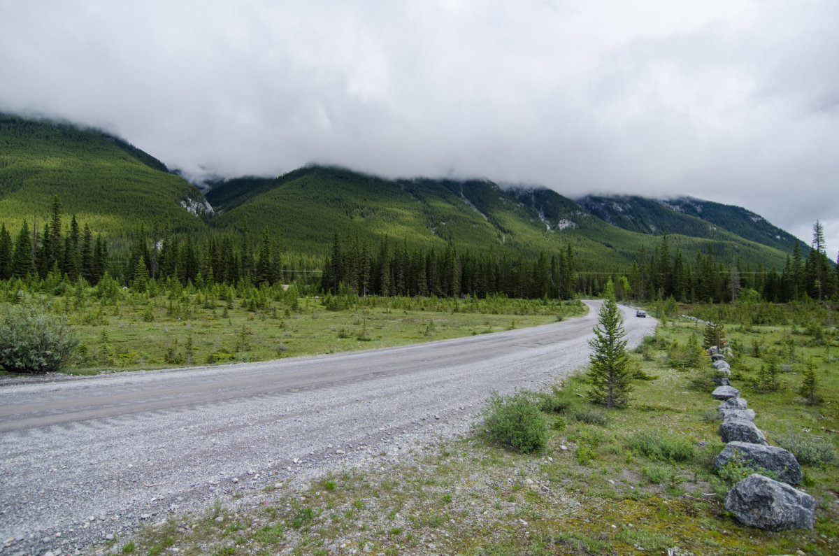
We have already talked about the fabulous short route that will take you from the busy Highway 1 between Calgary and Banff, along the Kananaskis Trail. The great news, for those who want a longer day trip, or even a two or three day journey through the area if you like to camp, is that if you are willing to get off of the paved roads, you can experience even more of this gorgeous area as you continue to travel south towards Crowsnest Pass.
Be prepared for sections of unpaved, gravel roads and few services, but the reward will be uncrowded wilderness areas and plenty of photo opportunities.
Follow the Kananaskis Trail to the junction of Highway 940 and turn right. The township and range roads will eventually turn back into Highway 40, which will take you to the town of Coleman in Crowsnest Pass. We suggest using GPS for this route.
Drive Distance: 213 kms (Stoney Nakoda Resort to Coleman)
Drive Time: 3.5 hours (no stops)
4. Smith-Dorrien Trail
Credit: Jeff Hitchcock/Flickr
This road can be pretty rough gravel in some sections, with a steep, winding grade near Canmore. Used as the back route into Peter Lougheed Provincial Park, this route will take you from Canmore to meet up with Highway 40.
The views will dazzle you as you head along Spray Lakes Reservoir and by Mt. Engadine Lodge. Keep your eyes peeled for moose, as they are commonly seen along this road. Using your GPS, find your way from Canmore to the start of Spray Lakes Rd/Three Sisters Pkwy/AB-742, then continue to the end where it joins the Kananakis Trail.
You can return to Canmore the same way or continue on to a different destination.
Drive Distance: 70 kms (one way)
Drive Time: 2 hours (one way to junction of Hwy 40)
5. Highway 1A – Bow Valley Trail
The major highway between Calgary and Banff is the Trans Canada Highway (#1), and there is no denying that it can get quite busy, not only with day-trippers and tourists but with the vehicles and semis that are travelling between Alberta and British Columbia.
A lovely alternative route is to take the old highway, from Calgary, through the thriving town of Cochrane and along Highway 1A to Canmore, where you can meet up with the main road into Banff National Park. Along this secondary highway, you will find some amazing views, along with wandering livestock and ranches, not to mention the lakes.
Ghost Lake is a great place to stop for pictures, or you can step out of your vehicle at Grotto Pond for some selfies in the area. There are some fantastic hiking opportunities along this route as well if you are looking to stretch your legs.
By Exshaw, keep your eyes open for big-horned sheep that frequent the area. This very pretty route is slower than the main highway and is quite curvy, so take your time and enjoy the drive.
Drive Distance: 111 kms (from downtown Calgary to Canmore)
Drive Time: 1.5 hours (no stops)
6. Highway 1A – Bow Valley Parkway
Bow Valley Parkway is a 51km scenic road and one of the two roads that link (Trans Canada Highway being the other) that connects Banff and Lake Louise. It begins at Highway 1 at Lake Louise, generally paralleling it until it meets Highway 1 again approximately 6 km (3.7 mi) west of Banff.
The drive that cuts through mountains and passes over the Bow River valley is replete with panoramic views and wildlife. Site of an old boomtown with five operating mines and a Canadian internment camp which held immigrant prisoners of Ukrainian, Austrian, Hungarian and German descent also lies along the Bow Valley Parkway.
Johnston Canyon, with spectacular waterfalls and ink pots, is also a noteworthy stop along the parkway. From March 1 to June 25, travel is not permitted between 8 p.m. and 8 a.m. in order to protect wildlife.
Drive Distance: 111 kms (from downtown Calgary to Canmore)
Drive Time: 1.5 hours (no stops)
7. Highway 3 and Crowsnest Pass
Running between the prairie city of Lethbridge and the stunning scenery of the mountains, this portion of Highway 3 is best travelled during the spring, summer or autumn months, as winter driving conditions can be challenging. The change in landscape is one of the reasons why this is such a fabulous route, as you make your way from the windy farmlands to the beautiful peaks of the Rockies.
There are plenty of little towns to explore along the way, as well as natural spectacles, such as Lundbreck Falls (which only requires a short detour off the highway).
Of course, you can continue into the province of B.C. if you choose to on this highway, but the Alberta portion is well worth it as a day trip, or plan a couple of days so you can experience the areas that you are driving through.
Drive Distance: 158 kms (Lethbridge to Crowsnest)
Drive Time: 1.75 hours (no stops)
8. Dinosaur Trail
This short route will take you through some of the most unique landscapes in the province and through some of the most famous and ancient areas of the Alberta Badlands. This is a very short route, but there are plenty of places to stop and explore along the way, so make sure you plan for a day to enjoy each and every site.
The viewpoints are incredible, giving visitors chances to view the valleys and canyons where dinosaur remains have been found.
The loop will take you past Midland Provincial Park, Horsethief Canyon, and give you a chance to use the free, cable-operated Bleriot Ferry, which has been running since 1913. Starting from the town of Drumheller, head out of town on North Dinosaur Trail (838), which leads you past the Royal Tyrell Museum (a must-see), following signs for Bleriot Ferry. Once you have crossed the river, turn left onto South Dinosaur Trail to return to Drumheller.
Drive Distance: 48 kms (loop road)
Drive Time: 1 hour (no stops)
9. Hoodoos Trail
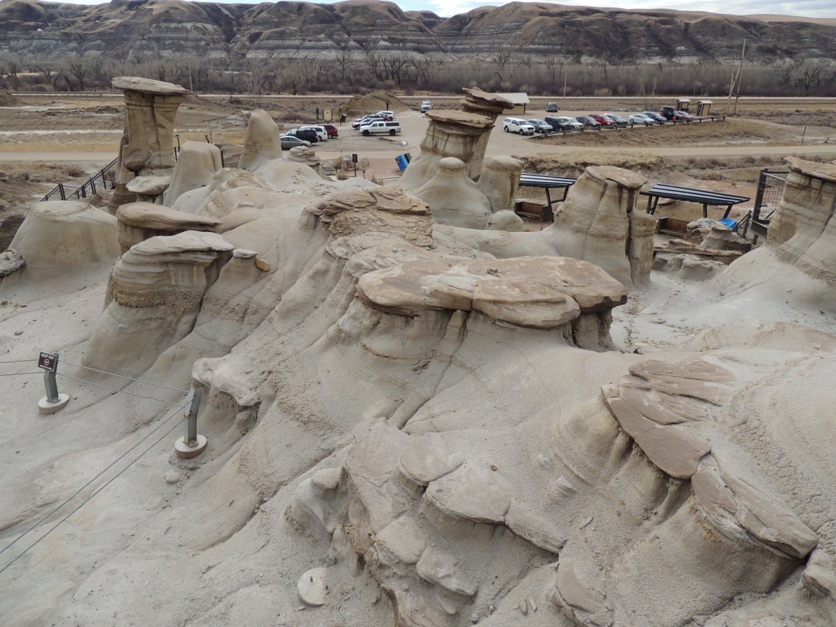
Credit: Kevin M Klerks/Flickr
In the Drumheller area, there are more than just dinosaur bones to be found. The incredibly unique hoodoo formations found in this region have been created by the erosion of the earth by wind and water.
These geological formations are something that can’t be missed if you are travelling through the area, and this lovely short drive route to the south of Drumheller will allow you to see more than just the Hoodoos – there is also an interesting mine and, with a slight detour, the chance to visit the haunted saloon in Wayne.
Head south from Drumheller along Highway 10, following signs for the Hoodoos. If you want to continue to the Atlas Coal Mine Historic Site, it is definitely worth it, using this as the turnaround point to return to Drumheller or continue to. Take the opportunity to head off on the side highway – 10X – to visit the small town of Wayne before returning to the main road.
Drive Distance: 42 kms
Drive Time: 1 hour (no stops)
10. Jasper to Mount Robson
While the end destination is technically in British Columbia, this drive is a beautiful day trip to take from Jasper, and worth it to see the highest mountain in the Rockies – Mount Robson at 12,972 feet (3954 m).
Starting from the mountain town of Jasper, in the National Park of the same name, you are going to drive through towering peaks along the iconic Yellowhead – Highway 16, west of the town. Take advantage of the pull-outs and rest stops to get off the busy highway to take pictures.
There are plenty of opportunities to see wildlife along this highway as well, so be aware that herds of elk, single moose, or bears frequent the area. Please watch your speed and do not get out of your vehicle to approach or take pictures of wildlife.
Drive Distance: 87 kms (one way)
Drive Time: 1 hour (no stops)
11. The Bighorn Highway
View this post on Instagram
Another section of Highway 40, this one takes you from just outside of Hinton, north to Grande Cache and then on to Grande Prairie. Once again, this highway has you travelling through some stunning wilderness areas as you travel through William A. Switzer Provincial Park, Pierre Greys Lakes Provincial Park, into the gorgeous Grande Cache area with its beautiful lake, across (and along) the Smoky River, and up to the small city of Grande Prairie.
This is not an easy journey, with few services, but you can’t beat the views. From Hinton, head west and watch for the sign that says – Scenic Route to Alaska – and turn right. Highway 40 actually ends at Grande Prairie, but if you have the desire to keep going north, you certainly could!
Drive Distance: 336 kms (one way from Hinton)
Drive Time: 3.75 hours
12. Chief Mountain Highway
View this post on Instagram
This is one of the most unique highways in Canada, as it connects the gorgeous Waterton National Park in Alberta to the Glacier National Park in Montana, USA. Don’t worry, you can turn around before or at the international border, just make sure to do it on the Canadian side!
The road takes you through the spectacular scenery that you expect to see in this part of the province, and through some interesting areas, such as the burn site of 1998. Even before you come to the border, you will have views of the dominating face of Chief Mountain. You can easily spend all day exploring this short drive. From the Waterton townsite, head north on Highway 5, turn right onto Highway 6 and follow to the border.
Chief Mountain Highway is open from May 15 to September 30. From October 1 – May 14, the road closes at the Belly River Bridge.
Drive Distance: 32 kms (one way from Waterton town to the US border)
Drive Time: 40 minutes
13. Akamina Parkway
Waterton National Park is full of stunning scenery, hikes, and opportunities to see wildlife. It makes sense that there is more than one scenic drive available through the park for those who want a more sedate travel opportunity.
This lovely drive takes you from the townsite of Waterton to the shores of Cameron Lake. Plenty of photo ops wait for you along the route, as well as historic stops and lots of trailheads if you feel inclined to walk awhile.
Cameron Lake has an interpretive exhibit, along with a pretty trail that follows the western shore. From the town, follow signs for the Parkway.
Drive Distance: 16 kms (one way)
Drive Time: 30 minutes (no stops)
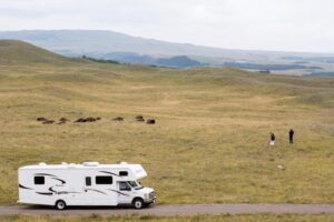
14. Cowboy Trail
The famous Cowboy Trail, also known as Highway 22, stretches through historic farmlands, alongside the distant peaks of the Rocky Mountains through rolling foothills, and embraces (almost) everything good that the province has to offer in terms of scenery. The varied landscapes along this one highway will enthrall you as you explore.
With numerous stops along this journey, you may want to allot several days to complete it. Start in Mayerthorpe, just outside Edmonton, and head south to Lundbreck, or vice versa; either way, you will get some phenomenal pictures and make memories for a lifetime.
Drive Distance: 570 kms (one way)
Drive Time: 6 hours (no stops)
15. Boomtown Trail
Anyone who has ever travelled the Queen Elizabeth Highway (#2) between Edmonton and Calgary may have noticed that the traffic is heavy, and the scenery is so-so.
For those of us who prefer to take more scenic routes and love smaller highways with less traffic, the Boomtown Trail is the perfect choice for exploring and admiring the scenery between Alberta’s two major cities.
Along with the beauty of the farmers’ fields, you will get views of rivers, lakes, ponds, and forests lining the roadsides, not to mention the abundance of birdlife and wildlife.
Keep your eyes open for Alberta’s iconic barns, train stations, and unique structures that can be seen along the way. If you don’t want to end up in Calgary, keep going south and hook up with the Dinosaur Trail to lead you to Drumheller.
Drive Distance: 415 kms (Edmonton to Three Hills)
Drive Time: 4.5 hours (no stops)

Explore Alberta
A Road trip From Edmonton to Jasper – Sun, Sand and the Mountains
A 15 Day Alberta Road Trip Itinerary
The 1A Bow Valley Parkway used to be a fantastic drive. Now it takes you almost an hour to get through Cochrane unfortunately
How about the drive from Lethbridge through Warner, Milk River, Cardston, Mountainview to Waterton. And then south to Glacier Park, Montana; and the Going to the Sun Highway! Talk about spectacular!
Another trip is going up Hwy 2 from Calgary to Sundre and then west to take Hwy 22 to Rocky Mountain House through Caroline and West on Hwy 11 to Saskatchewan River Crossing to the Columbia Icefields!