Hike to the top of Turtle Mountain, which crushed an Alberta coal town 120 years ago.
The Frank Slide Interpretive Centre
There are many places along the Crowsnest Highway from where you can get views of Canada’s deadliest rockslide, the Frank Slide.
The rockslide is Canada’s deadliest rockslide ever and covers an enormous area beside the Crowsnest Highway. The road is the first place from where you’ll notice the rubble. From there, you can head to the Frank Slide Interpretive Centre for a more elevated view of the immense piles of mountainside.
You can even get a birds-eye view of the Frank Slide site, but it requires a bit of a trek!
The Interpretive Centre is on the north side of the highway, while the start of the Turtle Mountain hike is on the south side, along with the mountain itself.
Hiking Turtle Mountain
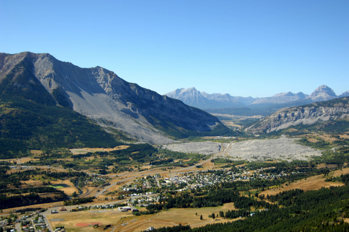
Embarking on the just over 7.2km out-and-back hike to the top of Turtle Mountain promises awe-inspiring views of the notorious slide and the nearby landscapes.
The trail starts with a sharper incline and climb, but the trail begins to steady, and the climb is a bit more gradual from there to the top. The total elevation gain is about 900m. It is considered a challenging hike thanks to the elevation gain, the sharp start to the trail, and the peak crossing at the top. There are two peaks, the North Peak and the South Peak. These peaks both belong to Turtle Mountain and were created from the rockslide.
The initial hike to the North Peak is relatively easy, and suitable for those with hiking experience, while advancing to the South Peak demands good scrambling and route-finding skills.
Proper gear, including hiking poles and boots, are advised due to rocky terrains and occasional high winds, emphasizing safety.
Hikers are rewarded with breathtaking views over the Crowsnest River Valley, including the Town of Blairmore, Crowsnest Mountain and the rockslide. There is a small wooden platform at the trail’s end and top of the mountain. It is the perfect place to sit and enjoy the incredible views of the Rockies.
The total hike can take 2 to 3 hours.
The Frank Slide Interpretive Centre
The Interpretive Centre is open year-round and begins limiting its hours for the winter starting in October. From the centre, you can embark on a less strenuous hike. The 1.5km interpretive trail gives you an up-close view of the site and boulders.
The Frank Slide Interpretive Centre screens two informative films about the rockslide, each at about 30-minutes long. Plus, the Centre has amenities like parking, washrooms, a gift shop, and picnic areas.
An annual race event, Run the Rocks, used to be held at the trail in September until 2021.
Cool Places to Stay in the Crowsnest Region
There are many great campgrounds along the Crowsnest Highway near Frank, and many hotels as well. But you can also take advantage of the natural beauty of the area with a cabin resort stay.
- Adanac Adventures have cabins and camping available year-round. The campground is only 10-minutes from Turtle Mountain.
- Charmed Resorts are further west on the Crowsnest Highway and offer dreamy places to escape with family or as a couple. Each cabin is modeled after a different fairy tale home and include unique cabins like Hook’s Pirate Ship, Belle’s Cottage, or Wendy’s Townhouse. Some of the cabins have their own hot tubs!
- Goat Mountain Get-A-Way is in Blairmore and has year-round cabins set in a scenic forested area on the west side of the town of Frank. From here, you could walk to the Turtle Mountain trailhead.
Dining on Highway 3
The direct area around the Frank Slide site does not have options for dining, but once you get beyond the rubble in Coleman, Blairmore, or Bellevue, you can find several local places to stop for a meal, snack, or drinks.
- For breakfast or brunch: The Cherry on Top Bakery and Koffie Shop and Stone’s Throw Café (Blairmore); Cinnamon Bear Café (Coleman)
- For lunch or dinner: Soo Blairmore; Crowsnest Pass Pizza; 5 Rivers Pizza Co; Vito’s Family Restaurant
- For drinks: Encounters Wine Bar & Small Plate Kitchen; The Pass Beer Co.
Plan your trip – Turtle Mountain Hike
What: An out-and-back trail up Turtle Mountain. This is the same mountain which lost thousands of tons of rock during Canada’s deadliest rockslide. The event, known commonly as the Frank Slide, covered the town of Frank with those thousands of tons of mountainside. The hike up the mountain offers rewarding views for the tougher climb.
Location and how to get there: south side of Highway AB-3.
Starting from the parking area situated at the gravel road’s end near 134 Street and 15 Avenue in Blairmore, a mere 5-minute drive from the Frank Slide Historic Site, hikers ascend 900 meters elevation. Reach the location by turning onto 129 Street from Highway 3, following a series of turns detailed in the original route description, until arriving at the trailhead, marked by yellow indicators past the parking spot.
Best time to go: hike is best to do spring to fall; Interpretive Centre open year-round
How much: Free to hike.
Trail access is free
For more information:


A great way to view Turtle Mountain is with a professional guide. Uplift Adventures is an incredible guiding outfitter located in Crowsnest Pass and Waterton.