Canada’s fall forecast for 2025 is shaping up to be anything but ordinary.
Credit: Weather Network
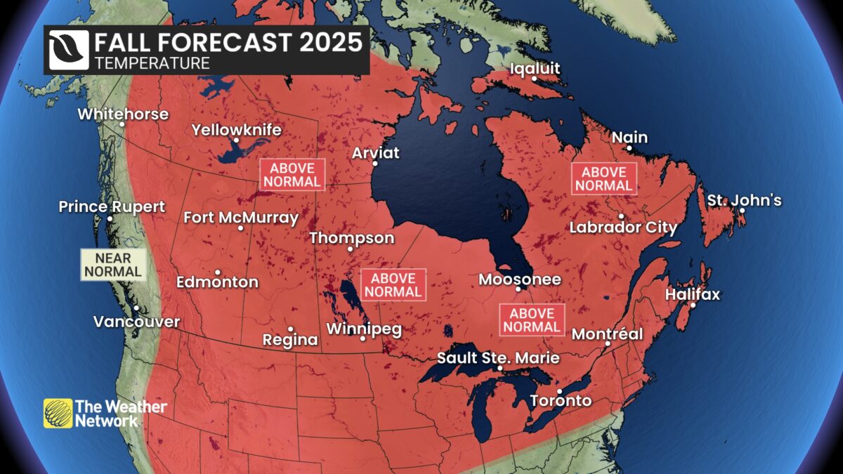
According to The Weather Network, much of the country will see warmer-than-usual temperatures through October, followed by a sharp pivot toward winter in November.
Senior meteorologist Doug Gillham explained that fall is naturally turbulent, but this year comes with a twist: “From mid-September through October, we expect an extended stretch of more consistent mild weather with fewer than the typical number of fall storms for most of Canada.”
That doesn’t mean smooth sailing everywhere. While mild weather should offer more time outdoors and easier harvest conditions, each region will have its quirks and challenges as the season unfolds.
The big takeaway? Canadians should soak in October’s extended warmth while they can, November’s weather shift may leave little doubt that winter is close at hand.
Regional Highlights
Credit: Weather Network
Here’s a breakdown of the Weather Network forecast by region:
British Columbia
-
Warm, dry September extends wildfire concerns.
-
Rainy season begins in October with heavier-than-normal rainfall expected.
-
Ski season likely to start on time despite storm risks.
Temperature Outlook: Above normal central and east; Near normal west
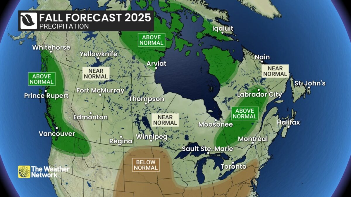
Precipitation Outlook: Above normal west and south; Near normal elsewhere
Alberta
-
Edmonton and Calgary can expect long stretches of mild October weather.
-
Precipitation near normal overall, but southern and western Alberta may see more rain.
-
November brings an abrupt shift to colder, stormier conditions.
Temperature Outlook: Above normal
Precipitation Outlook: Near normal
Saskatchewan & Manitoba
-
After a chilly start, warmer-than-normal temperatures dominate mid-September to October.
-
Good conditions for finishing harvests and enjoying outdoor activities.
-
November likely to deliver an abrupt dive into early winter.
Temperature Outlook: Above normal
Precipitation Outlook: Near normal
Ontario
-
London, Toronto, and Ottawa will see sunnier, warmer-than-normal conditions through October.
-
Fewer storms than usual means good leaf-viewing weather.
-
November could bring a rapid transition to early winter.
Temperature Outlook: Above normal
Precipitation Outlook: Near normal; Above normal northeast
Quebec
-
Montreal and Quebec City are forecasted to stay mild and sunny into October.
-
Fewer storms than average, extending opportunities to enjoy fall foliage.
-
November will test how quickly winter asserts itself.
Temperature Outlook: Above normal
Precipitation Outlook: Near normal south and east; Above normal west, central & north
Maritimes (NB, NS, PEI)
-
Halifax, Charlottetown, and Fredericton will enjoy a milder-than-usual October.
-
Dry conditions and wildfire risk persist after a parched summer.
-
Late-fall could see normal precipitation if tropical remnants sweep in.
Newfoundland & Labrador
-
St. John’s and Corner Brook face fewer fall storms than usual.
-
Above-normal warmth dominates much of the season.
-
Normal precipitation may return with late-season tropical systems.
Temperature Outlook (Atlantic Canada): Above normal
Precipitation Outlook (Atlantic Canada): Near normal
Territories
-
A warm first half of the season leads into heavy snow and ice later.
-
Above-normal precipitation raises the likelihood of an early winter build-up.
Temperature Outlook: Above normal NWT, eastern Yukon & most of Nunavut; Near normal western Yukon & northeast Nunavut
Precipitation Outlook: Above normal most of Nunavut; Near normal elsewhere


