Some of the most magical scenery of Waterton Lakes National Park is right near the entrance. Whether coming from the north, south, or east, the highways and roads into Waterton provide a one-of-a-kind Canadian landscape.
The eastern edge of Waterton Lakes National Park is a great place to explore during spring, summer, or fall, with several places along Highway 6 for pictures, picnics, or wildlife viewing.
The Unique Landscapes of Eastern Waterton
Within the National Park, there is a lot to explore and discover, from the scenery to the wildlife, and of course, the three main lakes. Each section of Waterton National Park, from the Redrock Parkway, Akamina Parkway, or the eastern edge of the park, offers different landscapes, views, and defining features.
Eastern Waterton Lakes National Park offers an incredible glimpse of prairie landscapes transforming into foothills, and then the Rockies. This lower-lying area of Waterton is where the Waterton River runs through the lush valley, where the rolling hills turn into meadows, and the Rocky Mountains are visible in the backdrop of it all.
And as the Highway 6 section of the National Park is set away from the lakes and townsite, these hiking trails are generally less busy or populated.
Hiking the Horseshoe Basin
The 20km adventure to, through, and around the Horseshoe Basin starts at Waterton’s Bison Paddock. Before your adventure, capture the sunrise or roaming bison. The trail leads through open meadow and fields before entering a valley between two lower mountains. And once you’re in the lowest part of the valley, it will be a good time for a rest. The next part of the hike involves crossing over part of Lakeview Peak.
The next fairly level section of the trail follows the northern edge of the park before heading south to follow the eastern edge of the park. This brings the hike all the way around Lakeview Peak.
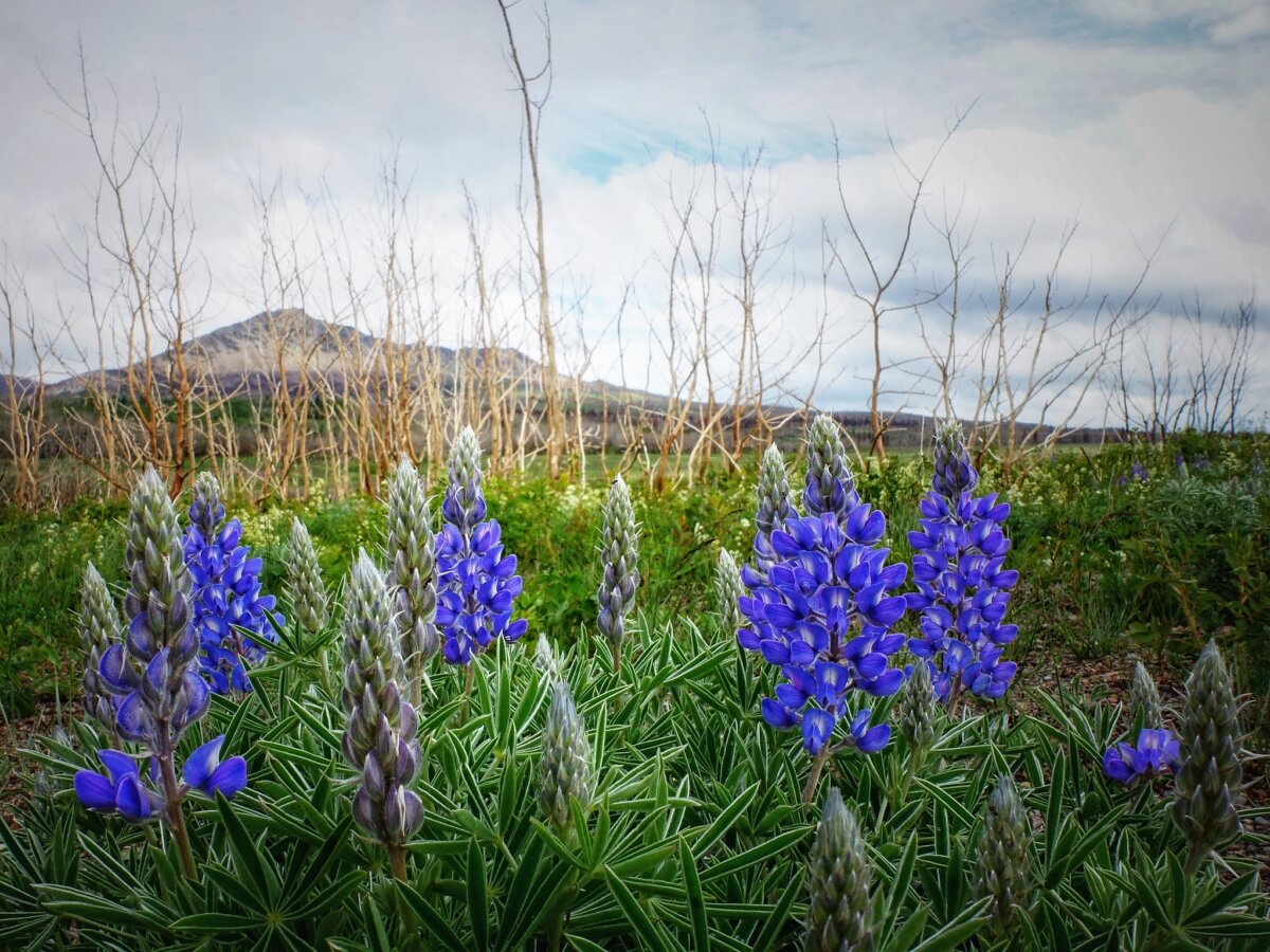
Spring (May/June) is one of the best times to complete the Horseshoe Basin trail, or even part of the hike. This part of Waterton Lakes National Park is famous for its spring wildflower blooms, with a huge variety of species to spot along the trail.
More Great Trails in Eastern Waterton
There are simple and challenging trails near the Horseshoe Basin Trail. Plus, the southern part of Highway AB-6 acts as a scenic route through several rest stops.
- The trailhead to the Horseshoe Basin trail is also the start of the Bellevue trail. This shorter, but still moderately rated hike, is 3.8km one-way and gets hikers to the Red Rock Parkway.
- The Wishbone Trail connects Highway 6 to the challenging hikes on the south side of the three Waterton Lakes. Take the trail as far out as you wish to get excellent views of wildflowers, lakes, forests, and mountains, all in one.
- The southern part of the Highway does not have any more trailheads, but several roadside stops with interpretive information about the nature and history.
Around Waterton Townsite
The townsite is located on the shores of the largest of the three lakes, Upper Waterton Lake, which extends south in the U.S. The town is home to shopping and dining, and is the starting point for many simple yet rewarding hikes.
- Cameron Falls and Bertha Falls are both within a short walk from the edge of town.
- The town’s shoreline is also a great way to get varying views of the area. This route begins at the marina in the north and could be followed all the way to Cameron Creek. All along the shore are picnic and rest areas.
- Embark on the area’s most exciting sightseeing adventures with Waterton Shoreline Cruise Co., open May-October each year.
- Find great opportunities for pre- or post-hike meals around the Waterton Townsite. Places like Wieners of Waterton, Switchback Café (also offers guided tours), and Pizza of Waterton are great options for takeout snacks.
- Get a sit-down dining experience at the Red Rock Trattoria, Lakeside Chophouse, or the Ram’s Head Pub.
Camping & More Accommodations in Waterton
National Park campgrounds are scattered throughout Waterton Lakes, including a campground right in town and the Belly River campground in the southeast of the park (which also offers a group campground). Beyond these campgrounds, there are also ample opportunities for backcountry camping across Waterton’s more remote areas.
- There are many other lodge and hotel-style options located in the townsite, like the famous Prince of Wales Hotel on the water, Kilmorey Lodge
- Waterton Lakes Lodge Resort, Bayshore Inn & Spa, or the Waterton Glacier Suites.
- Pincher Creek is only 56km north of Waterton National Park, making the small town another option for accommodations.

Planning your Trip – The Horseshoe Basin Trail
What: The 21.3 km Horseshoe Basin trail is a looping hiking trail around the northeast corner of Waterton Lakes National Park. Part of the trail follows the park’s eastern boundary. The trail is considered a moderate route given its length and time commitment, and only about 350m in elevation gain.
Location and how to get there: the trailhead is off Highway AB-6 at the Bison Paddock Road in Waterton Lakes National Park in southwest Alberta. A dirt road leads from the Bison Paddock to the parking and Horseshoe Basin Trailhead.
Cost: Free During Canada Strong Pass Days: June 19 to September 7, 2026
National Park Day Pass:
Adult: $12.25
Senior: $10.75
Youth: free
Family/Group: $24.50
Best time to go: April-October for hiking
For more information:


