British Columbia has some of the most scenic vistas in the entire country.
With a mixture of ocean, mountains, valleys, lakes, vineyards, waterfalls, orchards and farmland, the highways and byways of the province will take you past some amazing views. A road trip through the province will allow you to experience a little bit of everything.
SEA to SKY HIGHWAY (Highway 99)
Tunnel Point Viewpoint
The pull-out area is on the left side of the road if you are heading north, so it is best to hit this on your way back from Squamish or Whistler. There are some interpretive signs to give you some background on the area, and you will have to take a couple of steps out of the parking lot to get the best pictures. This is the start of a pretty popular trail but it also offers amazing views of the Coastal Mountains.
How to Get There
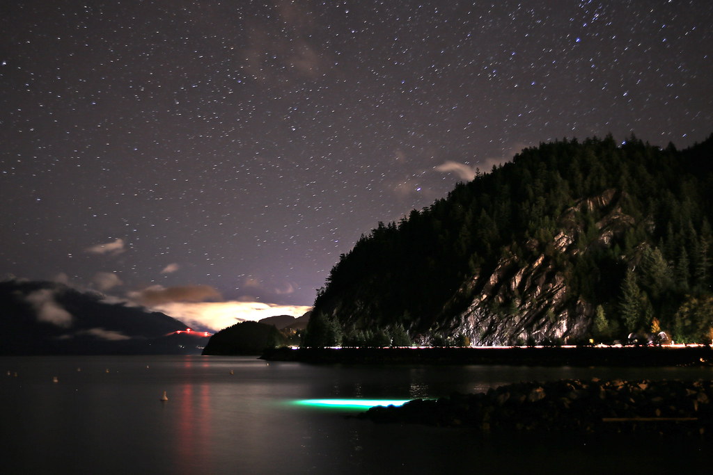
Porteau Cove, Squamish
You will need to leave the main highway to get to this viewpoint, but it is well worth the short detour. You can access the side road from either direction from the Sea to Sky Highway, taking the Porteau Road exit and turning east onto Porteau Cove Road. The viewpoint has some interpretive panels detailing the area as well as beautiful views of the cove and the surrounding mountain ranges.
How to Get There
Details
Nch’kay Viewpoint
Going north towards Whistler, as you round the corner towards Squamish, you will see the pullout area on the left. This viewpoint gives you a chance to see Squamish along with the amazing Mount Garibaldi in the distance. Part of the southernmost Coast Mountain Range, it is one of the most recognized peaks in the region, as well as the province’s best-known volcano.
Address: 4731 BC-99, Britannia Beach
Details
The Tantalus Lookout Point
Located 40 km south of Whistler, this is an excellent viewpoint towards Mount Tantalus. The mountain rises an impressive 2603 m (8540 ft) above the valley floor and is the highest in the range of the Pacific Mountains.
If you are heading north, watch out for the side road that heads up to a separate viewpoint, which has a cool wood bench and a decent amount of parking.
This is a quieter space than the southbound pull-out. Driving southbound you will quickly see the viewpoint pull off, with its informative signs and beautiful views. Either one is a perfect place to stretch your legs, take some fantastic pics or indulge in a picnic.
How to Get There
Details
DUFFY LAKE ROAD (Highway 99 Pemberton to Lillooet)
Duffy Lake Road Viewpoint
North from Whistler on Highway 99, you will travel through some spectacular scenery. This winding highway doesn’t offer many pull-out points, so take advantage of the viewpoint to take some pics of the area. The wilderness, lake and mountain vistas here are unparalleled.
The viewpoint is on the left side if you are heading north and almost halfway between Lillooet and Pemberton, just over 49 km either way.
How to Get There
Details
CROWSNEST HIGHWAY (Highway 3)
Hope Slide Rest Area and Viewpoint
While the surrounding mountain scenery is beautiful, this viewpoint is more about seeing the history here. The Hope Slide was one of the largest that has occurred in Canada’s history. The slide happened when the southwestern slope of Johnson Peak collapsed on January 9, 1965, ultimately spreading 47 million cubic metres of debris of 85 metres thick over a 3-kilometre stretch of the Hope-Princeton highway. The slide thankfully happened in an unpopulated area in the early morning hours but still resulted in four deaths.
You can find this rest stop and viewpoint just 18 km outside of the town of Hope. Look for the signs indicating the turn-off.
How to Get There
Details
Anarchist Mountain Lookout
For a fantastic view of Osoyoos and the Okanagan Valley, stop at this viewpoint. It can be accessed from either side of the highway and is only about 10 km outside the town to the east. Incredibly this is only about 4 km from the US border as well. The winding road will take you from 910 to 4,045 feet on Anarchist Mountain.
How to Get There
Details
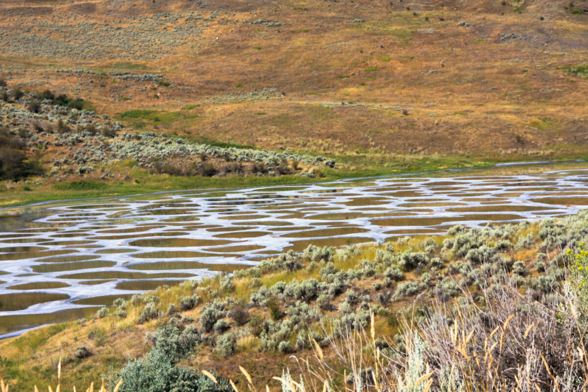
Spotted Lake
Remember that this is not an official pull-out, so if you are stopping, please be aware of traffic on the highway. The lake itself is on private property, but there is a small driveway area that you can park in to take a look at the highway. The views of this unique mineral lake are best in the hot summer months, as the water evaporates and the pools change colour due to the mineral contents. Head west on Highway 3 from Osoyoos to find the lake.
How to Get There
Details
TRANS CANADA HIGHWAY (Highway 1)
Sicamous Lookout
The town of Sicamous, located at the northern end of the Okanagan Valley, is known for many things, including being the houseboat capital of Canada.
The views from the valley are pretty enough but for a fantastic vista of the town, Mara Lake and Shuswap Lake.
Remember that this is located along an active logging road with not much parking, so please be careful.
The best views are from the hang-gliding platform, just a short walk from the lookout. There are several turns onto back roads from Sicamous, so be sure to use Google Maps to get you to the right place.
Address: 2V4, Old Logging Rd, Sicamous
How to Get There
Details
Summit of Rogers Pass
Located at the summit of the amazingly constructed Rogers Pass, this pullout has some interpretive signs amongst the stunning mountain scenery.
You can learn about the history of the men who built the road and tunnels, stretch your legs and get some phenomenal photos.
If you are heading east from Revelstoke, the pullout will be about 68 km away from Golden; heading west, it is about 81 km.
Details
Lower Spiral Tunnel Scenic Viewpoint
In the Kicking Horse Pass National Historic Site, you can find a good place to view the lower spiral tunnels built for the railway here. The pull-out and viewpoint is just over 7 km east of Field, where you can see the Lower Spiral Tunnel in Mt. Ogden.
Remember, as you drive on the Trans-Canada Highway near the Spiral Tunnels viewpoint, you’re following the path once known as the Big Hill.
If you are lucky, you may even be able to view one of the 25 or 30 trains that pass this way each day.
There is a second viewpoint where you can view the upper spiral tunnels in Cathedral Mountain from Yoho Valley Road.
How to Get There Lower Spiral Tunnel Scenic Viewpoint
How to Get There Upper Spiral Tunnel Scenic Viewpoint
Details
VANCOUVER ISLAND
Mount Tolmie Park – Victoria
There are lots of places to get a 360-degree view of the city of Victoria on Vancouver Island, but not all are accessible by vehicle. This park offers a fantastic viewpoint that will give you the range you are looking for with no effort!
Address: 3492 Mayfair Dr #3486, Victoria, BC V8P 4P9
Details
Malahat Viewpoint – Malahat Highway (Trans Canada Highway)
This portion of the highway was completed in 1911 as a direct route to Victoria. It only covers a 20-kilometre stretch but has phenomenal views of the area. There are interpretive signs describing the Cowichan Region and the lovely vistas.
This lookout area is only accessible when you travel north and adjacent to the highway, which is quite busy, so be careful when pulling in and out.
How to Get There
Details
Split Rock Lookout (Malahat Highway)
Two minutes farther down the Malahat Highway, there is another photo-worthy stop. Accessed only as you are travelling north, this lookout is about 300 masl which gives it the perfect altitude for fantastic views to the east and south.
You can look east over Saanich Inlet, to Saltspring Island to the northeast, the Saanich Peninsula and Mount Newton in John Dean Provincial Park, and the San Juan Islands and Mount Baker of Washington in the distance. You may be able to catch a pic of one of the local ferries crossing as well.
How to Get There
Details
Fairy Lake Recreation Site (Pacific Marine Road)
While you can use the recreation site as your destination, most people will look for the unique factor to get the best photo of this lake, and that would be the little tree growing out of a log in the lake. This picture op is a bit farther down the road than the recreation area.
You can walk along the highway or pull over on the shoulder when you see it. No matter how you stop, be careful; the highway is only two lanes, and there is no designated pullover area right in front of the tree.
You will find this lake on Pacific Marine Highway less than 15 minutes from Port Renfew.
How to Get There
Details
BANFF WINDERMERE HIGHWAY (Highway 93)
Kootenay Valley Viewpoint
Along Highway 93, you can enjoy breathtaking views of the Mitchell and Vermilion mountain ranges from the Kootenay Valley Viewpoint, just 16 kilometres from Radium Hot Springs. The valley and mountains create amazing backdrops for travel photos, and if you have the time and you want to, you can take a short hike from here down into the valley.
How to Get There
Details
CASSIAR HIGHWAY
Bear Glacier – Highway 37A
Travellers who are on the Cassiar Highway, heading either north or south, have the opportunity to take a slight detour down Highway 37A towards Stewart. Just 65 kilometres down the road, you will find the pull-out to view this magnificent glacier. The pass was once entirely filled with ice, but in the 1940’s the ice began to retreat and formed Strohn Lake. You can’t beat the beautiful photos you will be able to take of this ancient ice.
Mehan Lake Provincial Rest Area
Along the Cassiar- Stewart Highway there are some small towns and unofficial pullouts that you can stop at to take pictures, but this provincial rest area allows you some space to have a picnic (on actual picnic tables) and enjoy the northern B.C. view.
In early summer, you can see plenty of colourful fireweed along the road here, and watch out for animals, they are also plentiful in this area. The surrounding mountains and the beautiful lake create a perfect backdrop for vacation pics.
From Meziadin Junction, heading north, you will find Mehan Lake at kilometre 89. From Dease Lake heading south, you will come across it at kilometre 241.
Details
SALMON GLACIER ROAD
Toe of Salmon Glacier Viewpoint
To get to this viewpoint, you will have to travel from Meziadin Junction down Highway 37A to Stewart. You will be going briefly through Alaska, so make sure you have your passport with you.
There are actually quite a few things to see along this road, so take a picnic lunch with you and enjoy it at the foot of the glacier. Your friends will be amazed at the gorgeous pictures you take here. This viewpoint is located 27.7 kilometres down Salmon Glacier / Granduc Road from Stewart.
Details
Salmon Glacier Summit Viewpoint
Since you have already followed the road to get up close and personal with the toe of the Salmon Glacier, you might as well continue another (almost) ten kilometres down the road to the summit viewpoint, which is always worth some time. Follow the directions listed in the description above. Located at kilometre 37, the summit view will give you a slightly different perspective of the fifth-largest glacier in Canada.
Details
https://www.instagram.com/p/B2p_Aetiyvg/
ATLIN
Llewellyn Glacier Lookout
There are certain places in the province of British Columbia that can only be accessed by travelling through the Yukon. The Atlin area is one of them. If you have managed to make it to the town of Atlin, in the beautiful north of B.C., then you definitely want to head out to the lookout that will allow you to take some amazing photos of Llewellyn Glacier.
This glacier is the second largest in the Juneau Icefield. Of course, the entire area is chock full of photo ops, but this is a unique vista that is worth the short drive. From Discovery Avenue, turn onto Warm Bay Road, heading east. You are going to pass the Pine Creek Campground, and Pine Creek Beach (which also offers excellent views), and you will need to slow down significantly for Suicide Hill. The lookout for the Glacier is 12.2 kilometres from the corner of Discovery Avenue.
Details
HIGHWAY 16 (Trans Canada Highway North)
Mount Robson
While multiple people stop in or on the side of the highway to take a picture of the stunning Mt. Robson, we certainly don’t suggest it! You can capture a great picture from the parking lot of the Visitor’s Center instead, safely out of the line of traffic. The top of this 3,954-meter peak is almost always covered in clouds, but no matter how you view it, the mountain is incredible. From Jasper, AB this viewpoint is just about 27 kilometres, and from the town of McBride, it is just over 76 kilometres.
How to Get There
Details
Dome Creek Rest Stop
While this stop may not have the absolute best views of the mountains, you can still see the peaks here. The breathtaking view, instead of looking up, is captured by looking down. The creek, in all seasons, is so pretty with the background of forest that you probably won’t ever want to leave. The benefit of this viewpoint is the fact that there are heated bathrooms and lots of picnic spots to enjoy.
From McBride, you will find this stop about 88 kilometres to the west; from Prince George, it will be 120 kilometres to the east.
How to Get There
Details
HIGHWAY 24
Lac des Roches
Considered to be one of the most photographed lakes in the province, this is a beautiful place to take a rest along Highway 24.
You will find this viewpoint 65 kilometers southeast of 100 Mile House, or 129 kilometers northwest of Kamloops. The provincial rest stop offers incredible views of the lake and the low hills in the distance. A historic area, you can still see evidence along this highway from the early fur trading route.
How to Get There
HIGHWAY 20
Farwell Canyon Viewpoints
This is a unique area, so if you can, it is worth the side trip to visit this lookout point. There are interpretive signs explaining the geography and the naturally formed hoodoos here and a bit farther down the road there is a second viewpoint which offers up some amazing views of the hoodoos and sand cliffs, as well as the river. From the junction of Highway 7 and Highway 20 in Williams Lake, head west on Highway 20 for 46 km. Turn left, following the signs, onto a good gravel road for 15 km to the first viewpoint. If you continue down the road and cross the bridge, there is a pull-out on the right at approximately kilometre 22.
How to Get There
Details


Great list but honestly needs a map to show where they all are…