Credit: Victoria Harrison/To Do Canada
During the long sunlight hours of the summer months in the Yukon it is natural for outdoor enthusiasts to want to spend all their time exploring the area. From multiday treks to half day hikes, there are hundreds of kilometers of hike worthy trails in the Whitehorse area. It would be impossible to list them all here, so we have compiled a list of a mixture of easy, medium level and difficult hikes that are within driving distance of Whitehorse. Most can be completed in a day.
Keep in mind that no matter where you are, near the city or in the wilderness, there are chances that you will run into a bear or other wildlife. Make sure you carry bear spray and a whistle with you, attach bear bells to your pack, or make a sufficient amount of noise while you are walking. Stop at the Visitor’s Center in Whitehorse to get more information on bear safety while hiking.
Most hikes can only be accessed if you have a private vehicle. As well, in most places outside of Whitehorse there is no cell service. It is recommended that you carry a sufficient amount of water, snacks, basic first aid supplies and sufficient clothing for the weather. If you plan to hike alone, notify someone of your intended route before leaving cell service.
Visit the visitor centre in Whitehorse to get trail maps and booklets before you go.
The Millennium Trail
Credit: Canadian Tourism Commission
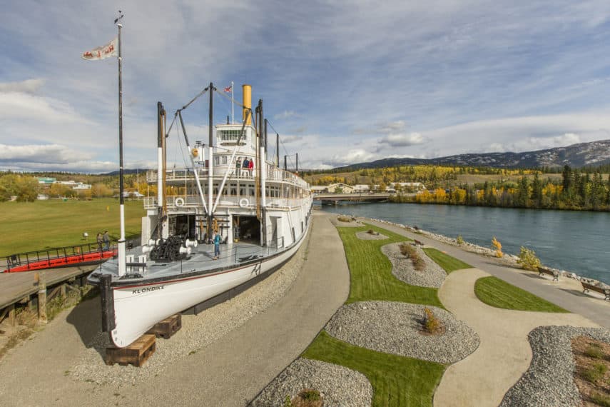
The Millennium Trail takes you along the waterfront of the Yukon River, over a pedestrian bridge and through the area of Riverdale before looping back to where you started. The total length is approximately 5 kms along a fairly level paved path. You pass by the S.S. Klondike and through some lovely wooded areas along the way. A light walk with fantastic views of the river and chances to see some wildlife, it is popular among residents here.
Miles Canyon Loop
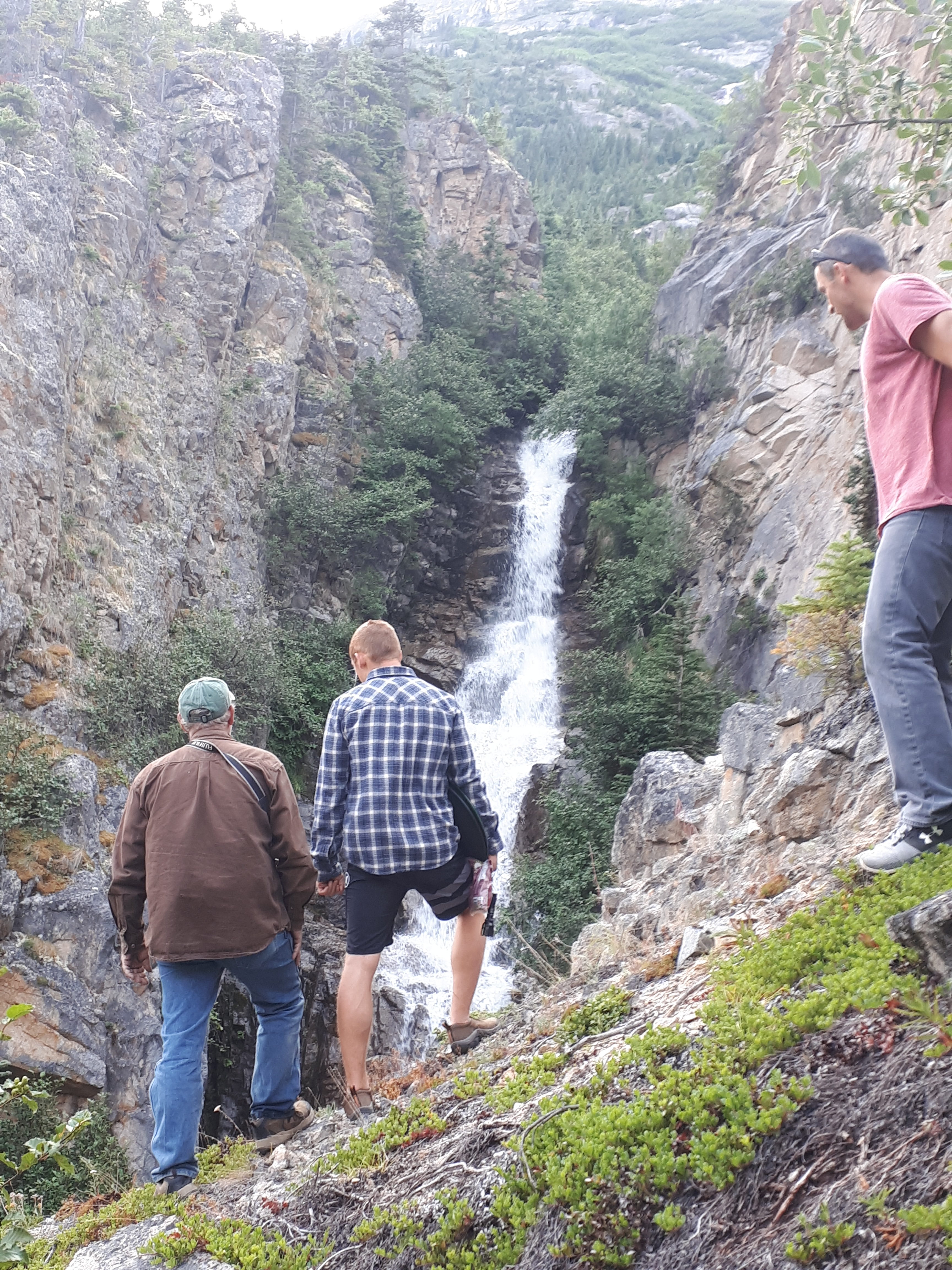
There are a couple of options when it comes to hiking in Miles Canyon. If you like, start right downtown in Whitehorse and head out on the Millennium Trail to the Fish Ladder (worth a visit anyway), then start the hike up Lookout Trail. There should be signs indicating the way or ask someone at the Fish Ladder to point you in the right direction. The trail continues along Schwatka Lake to the Yukon River and into the Canyon itself. There are several places that you will pass by parking lots or paved roads, just continue to follow the signage. Once you reach the suspension bridge you can cross and follow the trail along the river back to Whitehorse. This total loop is just over 15 kms in total and don’t forget to carry some bug spray and bear spray with you.
The second option is to only do part of the trail or explore the other short trails in the area. Park at the area by the suspension bridge. You can cross here and either turn left to hike the area towards Whitehorse or turn right to explore other trails. No matter what you choose, you will be enjoying fantastic views and a decently easy, well marked hiking trail.
Miles Canyon to Canyon City
If you don’t feel confident hiking on your own in the area, or if you would like an introduction to hiking in the area you can enjoy a free guided hike from Miles Canyon to Canyon City during the summer months. There are two departures daily that leave right from the Suspension Bridge by the parking lot. During the two-hour hike, your nature guide will not only give you information about the geology, plants and animals, but will be able to talk to you about the Gold Rush history and the First Nations of the area. You don’t have to register for this hike but check out their departure times on their website before going.
https://www.instagram.com/p/By0BFLZnJy9/
Details
Fish Lake Loop
Head north on the Alaska Highway to Fish Lake Road and turn left. About 15 kms down the road you will find Fish Lake where you will want to continue past the main parking area down a narrow road that leads to the right, where you will find parking right in front of the trailhead.
This trail is a total distance of about 16 kms and is classified as a moderate hike. With great views from the ridge, this trail takes you above the treeline where you can get a panoramic view of Fish Lake, Bonneville Lake and Boundary mountain range. Be aware that parts of this trail can be muddy die to frequent horse use. The trail starts climbing gradually and after an hour you should reach the treeline, after which you can climb to the summit. There are many options to explore from up here, including heading down to Bonneville Lake, where if you choose to, you can camp overnight. You return to your vehicle along the same route.
https://www.instagram.com/p/BXJs3Jeg48u/
Grey Mountain Trail
There is little elevation gain (only 200 m) so most of the hike is alpine walking. You can choose to turn around at the summit or continue exploring along the ridge. You want to head to Grey Mountain Road and the Grey Mountain Viewpoint. You can drive past the main parking area at the viewpoint and continue on for another 4 km but be aware that the road is rough! There is a good parking area right at the communication tower, and this is where the trails start. There is actually more than one trail departing from here, but they all end up in the same place. You can follow the most travelled trail up about 2.5 kms where you will reach the first summit and have a fantastic view. If you want to continue on, you can follow one of the main trails to the lower peak. If you decide to keep going, there is a third peak as well, but you have to descend out of the alpine and may have to do some bushwhacking. There isn’t much of a trail at some points, so be careful as you go.
The work is worth it, the third peak has the best view of Whitehorse! You will have to follow the same route back down to your vehicle.
Golden Horn
A moderate hike that can be done in a day, this is located right by the ski hill outside of Whitehorse. Just head south down the Alaska Highway and turn to follow the road to the Mount Sima chalet. About 1 km past the chalet you will see an area where you can park. Don’t continue down the road unless you have a good 4-wheel drive vehicle. The start of this hike is really the rest of the road, about 4.5 kms in total until you find the beginning of the actual trail. At the end of the road you will find an information kiosk about caribou in the area. From here you need to head up an ATV trail that will take you most of the way up the mountain. The ATV trail heads south, parallel to Golden Horn, towards the southern end of the ridge. It may seem like you’re actually getting further away from the mountain but continue following the trail as it is much easier than bushwhacking. When the ATV trail ends, you will see some grassy areas that lead to the summit. You will need to return by this same route, and it is hard to see the ATV track from the top, so you may want to leave a marker here to see on your way down. Follow these grassy areas up until you are in the alpine, then head straight for the summit (slightly to your left). The views from here are incredible and overlook Whitehorse, Lake Laberge and the mountains and lakes in the valley towards Carcross.
Mount Lorne
There are two options for this hike, the first about 19 kms in total, the second about 23.5 hours in total and is classified as a difficult trail. Leave the whole day available for this hike, just in case you get up there and decide to do the whole loop.
From Whitehorse head to the South Klondike Highway towards Carcross. After the Annie Lake Road turnoff keep your eyes open for Bear Creek, after which there will be parking pull offs on both sides of the highway. The trailhead is on the north side of the highway (left side of Bear Creek). Follow the creek for about 50 meters, then the trail meanders off into the trees until you come to a T in the path, make sure you turn right, unless you want to head to the house located on the left. From here you continue along beside the river and through the spruce trees for almost 6 kms until you reach an old trappers’ cabin. This is where the trail gets tricky. Look for a small path behind the cabin which climbs steeply upward. This trail eventually takes you to the top of the ridge where you get a nice viewpoint of the area. Follow the ridge right up to the first summit which is identifiable by its black, rocky surface. The route is steep and requires some scrambling. Take the easiest route, which is around the left side of the peak. From here you can see Whitehorse and Grey Mountain to the north, Marsh Lake to the east, McConnell Kae to the west and Bennett Lake to the south. If you are not continuing on, this is your turn around point.
If you are going to do the entire loop, you can continue along the ridge to the other side. From here you descend onto an ATV trail that will eventually loop back the main trail and the cabin. Be prepared for some scrambling along the ridge. At the end you can descend down the broad shoulder and find the ATV trail. Aim for the ridge towards the left.
Mount White
Being located so close to Whitehorse, this is a moderate to difficult day hike that offers slightly different views of the area – the Atlin lakes. This trail is not available to hike from April 1st to June 16th as it is a prime area for mountain goats to nurse and raise their kids. Drive south to Jake’s Corner and turn right onto Tagish Road to follow the signs for Atlin. After 6 kms you will need to look for a road on the left that leads to a gravel pit. At the southwest end of the parking lot look for the trailhead. The path leads into the trees and then relentless uphill. Some of the steeper sections can be slippery and muddy so you may want to consider using hiking poles.
When you reach the radar tower it will only be another 1 km to the top. The summit is a plateau spotted with white limestone rocks and spectacular views to Little Atlin Lake, Mount Minto and Atlin Lake. You can explore the ridge and range at the top before heading back the same way.
Spirit Canyon
This is a gorgeous area to explore and only about 50 kms outside of Whitehorse to the north. It is not visible from the road, so this is a great place to get some of those really off the beaten track experiences. Head north on the Alaska Highway towards Haines Junction. After about 50 kms turn right onto Kluane Wagon Road, drive for 1.25 kms and park on the side of the road. The trail starts from the trees on the left side of the road and you may have to bushwhack until you hit the grassy area. Continue to head west until you reach the lower part of the ridge, where there is plenty of open area to walk on the side of the south facing ridge. From the trail you get the views of the Ibex Valley and Takhini River Valley. Stay on the lower ridge to avoid the rocky areas and elevation. After 1.5 kms you will reach the lower canyon viewpoint, from which you can continue on to explore the canyon itself, by heading down to your left to find a small trail that heads north into the canyon. This trail takes you along the left wall of the canyon and to the end, where you will be surrounded by the huge rock walls. Head back the way you came and find the second trail to take you to the upper canyon viewpoint on the east side of the canyon. From here you can explore the animal trails (don’t get lost) or return to your vehicle along the same path.
Valerie Lake (Copper Trail)
Chilkoot Trail
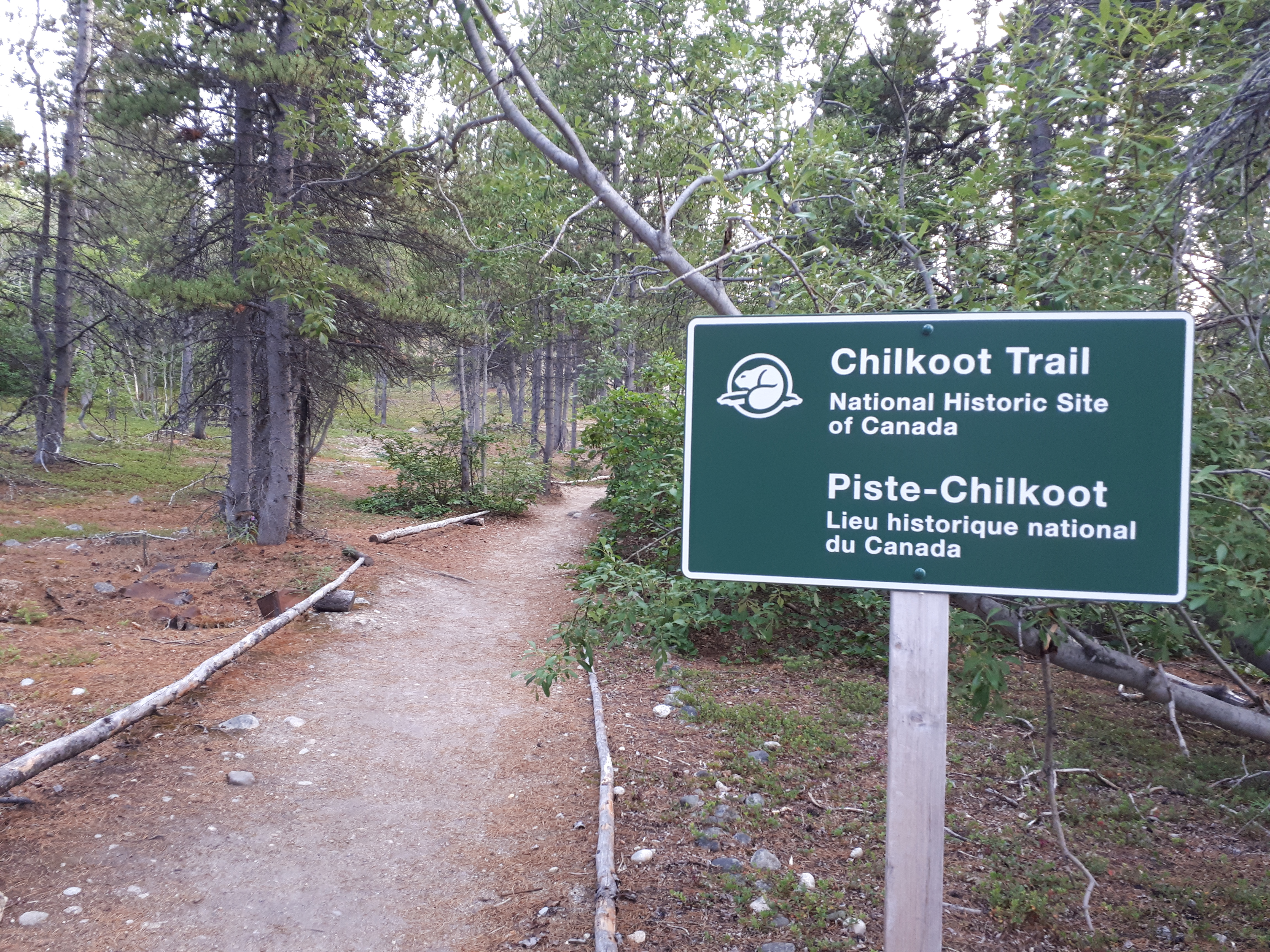
We couldn’t really have a list about the best hikes around Whitehorse without including the Chilkoot Trail. Each year there are more than 3,000 hikers that attempt to complete this famous Gold Rush trail. The experience of hiking the Chilkoot is really like making your way through an outdoor museum. The trail is lined with gravestones and relics of the miners that passed through in the late 1800’s. Keep in mind that this trek starts by Skagway, Alaska and ends in the Yukon. You must register and reserve your space in advance as there is a limit to how many people are allowed to trek at one time. Consider hiking in and taking the train out!
Nares Mountain Trail
This is a 7-km hike that takes you up the bare slopes of Nares Mountain. From the South Klondike Highway take the Tagish Road northeast for 2 km until you see a green sign for Choutla Subdivision. Continue down this road, staying right at the fork and after 1 km you reach Blattas Point Rd on the right. (there is a big yellow dead end sign). Follow this road for 2 km to the very end where it ends at a private driveway. There is a small parking area just passed the driveway. The trail starts from the parking area as you head up the open slope to the northeast. You will be aiming for the left ridge, so don’t follow the path to the right unless you are planning to do a much longer loop hike. Stay on the left of the gully to reach the open ridge where you begin the ascent. The higher you go the better the views, so keep going until you reach the summit. At the top there is a plateau that offers different views depending on where you are standing and from the main high point you can get the amazing 360 degree views that you want. The southwest point of the summit that looks down to Nares Lake and across to Montana Mountain, or check out the southeast views of Tagish Lake, Bove Island and Lime Mountain. You need to return by the same route.
https://www.instagram.com/p/BNF_v7XB9Kr/
Montana Mountain
From the town of Carcross, drive south on the South Klondike Highway across the bridge and take your first right. Take the next left up a gravel road and continue straight up, this is Montana Mountain Road.
Drive for about 8 km on this road until you reach a small washout area which you may or may not be able to cross by vehicle. If you can’t, you will have to park here and walk to the trailhead. There is also a landslide area at km 10 that is impassable by vehicle, so this is considered the trailhead. Cross the landslide area carefully and continue walking up the road for another 2.5 kms where you come to an open plateau and a fork in the road. Montana Mountain is directly in front of you. Take the road to the right and follow it as it winds its way to the mountain or choose to walk across the plateau and intersect the road. After the plateau you have a choice of how to climb up the mountain by either taking the ridge on the far right or walking straight ahead to climb up the couloir to the saddle between the ridge and the summit. Both options are decently easy, with the ridge being a longer scenic route and the couloir a more direct, steeper route.
You can also choose to do a loop by going up one way and coming down the other. To get to the couloir, you need to walk up the road towards the ridge to your left to find a small tarn below the ridge cirque. The couloir is straight up from this alpine tarn. Expect to scramble up to the summit from the saddle. If you prefer to walk along the ridge, follow the road leading to the right-most ridge. Once on the top you can easily walk along towards the saddle below the summit. From the summit, you get a 360 degree view of the area, including Grey Mountain, Mount Skukum, Bennett Lake, Tutshi Lake, Tagish Lake, and down to the White Pass and Chilkoot area.
Please Note: that the Montana Mountain area is within critical post-calving habitat for the Carcross Caribou Herd of the Southern Lakes Region. If you come across any caribou always keep your distance.
Sam McGee Trail
From Carcross, head towards Skagway on the South Klondike Highway to a point where you will see an old tramway on the left side. Immediately after the tramway, the highway will curve to the right over a creek and there is a gravel road on the left. Park at the top of the gravel road or just down the hill in a large gravel pit. To get to the trailhead, cross the highway (carefully watching for traffic) and walk down into the ditch, heading right until you reach a wooden post with a small trail sign on it for the ‘Mountain Hero Trail’. The path is clearly visible through the trees from this point.
After 4 kms of climbing steadily up this open trail, there will be a fork in the path. The left path will take you another few hundred meters where you can get an expansive view down toward Windy Arm. This is a good path if you want to see more tramway artifacts. If you don’t want to continue hiking up any further, you should take the left path so that you can get the amazing view right away. The right path is part of the Mountain Hero mountain biking trail which continues all the way around Montana Mountain, so if you want to go for a longer hike, you can follow this path. You will need to turn around at some point though if you want to return to your vehicle.
Note: Please avoid hiking this trail from mid-May to mid-June to avoid disturbing the mountain goats during kidding season.
https://www.instagram.com/p/8cS9hdmTZw/
Venus Mine
This is another interesting and beautiful trail if you want to check out an old mine in the area.
Head south from Carcross along the South Klondike Highway until you see a pull out with a yellow gate on the right side of the road (about a 10-minute drive). This is the parking area and the trailhead for this hike.
The start of the trail is an old mining road that zigzags up the mountain. It is extremely common for people to get off the path here and find different ways of getting up to the actual mine. Please note that some parts may be very slippery and steep so good hiking shoes are a must. Once you get to the mine you can check out the inside (if you have a flashlight), but please don’t climb on the structures as they may be unsound. You will need to return the same route that you came up.
You only need a couple of hours to do this, so it’s a good quick hike for those who don’t have much time.
https://www.instagram.com/p/BWnWutZFxg-/


