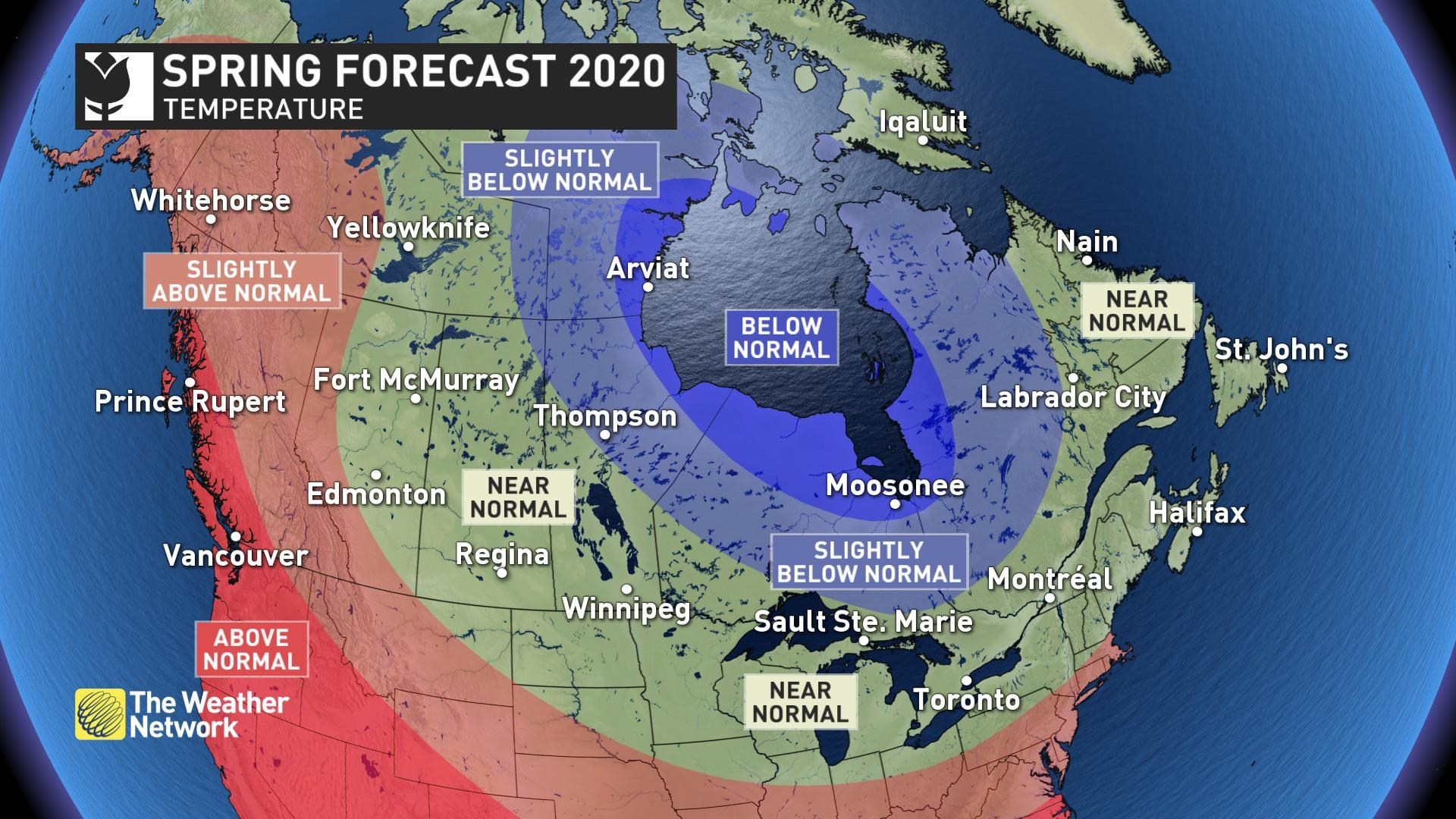
Spring Forecast Temperature Map (CNW Group/The Weather Network)
Ontario’s Wiarton Willie predicted early spring, and Nova Scotian Shubenacadie Sam predicted 6 more weeks of winter. Now, Weather Network is saying that most Canadians will have to wait patiently for the arrival of consistent warm weather.
The Weather Network Spring Weather Forecast for 2020
British Columbia
The Weather Network expects that spring will get off to a slower start than many recent years, which will result in excellent spring skiing and help to make up for the slow start to the ski season. However, spring will finish strong across the region with temperatures tipping to the warm side of normal. Near normal rain and alpine snow are expected.
Temperature Outlook: Above normal
Precipitation Outlook: Near normal
Prairies
Alberta, Manitoba and Saskatchewan can expect several weeks of colder than normal weather. Near normal precipitation is expected for much of the region, but a wetter pattern is expected near the U.S. border of Manitoba and Saskatchewan.
Alberta
Temperature Outlook: Above normal west and south; Near normal east
Precipitation Outlook: Near normal
Saskatchewan
Temperature Outlook: Near normal
Precipitation Outlook: Near normal; Above normal near U.S. border
Manitoba
Temperature Outlook: Near normal; Below normal north
Precipitation Outlook: Near normal; Above normal near U.S. border
Ontario and Quebec
The region can expect varying and wet spring weather. Regions near Great Lakes and with deep snowpack can expect a heightened risk of spring flooding to areas as an active storm track will continue to bring above normal precipitation to the region. Weather network expects temperatures to bee near seasonal across southern areas, and warmer than the previous two springs. However, an interruption to the pattern is expected with several weeks of colder than normal weather before consistent warmth arrives. Northern areas will to be colder than normal.
Ontario
Temperature Outlook: Near normal south; Below normal north
Precipitation Outlook: Above normal; Near normal far north
Quebec
Temperature Outlook: Near normal south and east; Below normal north and west
Precipitation Outlook: Above normal south; Near normal elsewhere
Atlantic Canada
Atlantic Canada can expect a few more high impact winter-like storms. Spring will arrive with the usual roller coaster swings in temperature. As the snow pack is currently less than it has been during recent years, the threat for spring flooding is not as high.
Temperature Outlook: Near normal
Precipitation Outlook: Above normal for much of the Maritimes; Near normal for Newfoundland
Northern Canada – Yukon, Northwest Territories, Nunavut
An unusually strong polar vortex will keep colder than normal temperatures across parts of the region well into spring, but above normal temperatures are expected to prevail across the Yukon.
Temperature Outlook: Above normal Yukon and western NWT; Below normal western and central Nunavut; Near normal elsewhere
Precipitation Outlook: Above normal western Yukon; Near normal elsewhere