Environment Canada has issued a tornado watch for Ottawa-Gatineau and Eastern Ontario.
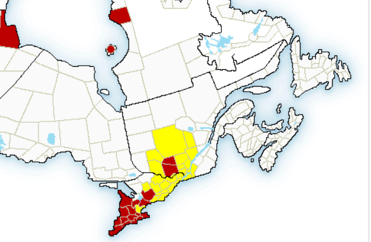
Screenshot; Environment Canada
The weather agency says conditions are favourable for the development of severe thunderstorms which may produce tornadoes this afternoon and early this evening.
Environment Canada says thunderstorms are expected to develop early this afternoon and a tornado or two may be possible as the storm intensifies as it travels eastward.
According to the alert, wind gusts of 90 to 110 km/h and nickel to ping pong ball size hail may also occur.
The tornado watch is in effect for:
Ontario:
- Ottawa
- Maxville – Alexandria
- Winchester – Newington
- Bancroft – Hastings Highlands – Denbigh
- Kaladar – Bannockburn – Bon Echo Park
- Prescott and Russell
- Barry’s Bay – Killaloe
- Petawawa – Pembroke – Cobden
- Renfrew – Arnprior – Calabogie
- Plevna – Sharbot Lake – Western Lanark County
- Smiths Falls – Perth – Eastern Lanark County
- Stirling – Tweed – Madoc
- Tamworth – Sydenham – South Frontenac
Quebec
- Gatineau
- Lachute area
- Saint-Eustache area
- Saint-Jérôme area
- Berthierville – Saint-Gabriel area
- Mascouche area
- Rawdon – Joliette area
- Mont-Tremblant – Sainte-Agathe area
- Saint-Donat – Mont-Tremblant Park area
- Saint-Michel-des-Saints area
- La Minerve – Rouge River area
- Fort William – Shawville area
- Rapides-des-Joachims area
- Lièvre River area
- Low – Wakefield area
- Maniwaki – Gracefield area
- Papineau-Labelle Reserve area
- Papineauville – Chénéville area
The agency is asking people in the affected area to be prepared for dangerous and potentially life-threatening weather conditions.
At the moment, severe thunderstorm warnings are also in effect for parts of Ontario including Dufferin – Innisfil, Peterborough – Kawartha Lakes and York – Durham.
The city of Toronto and various other cities are also under a severe thunderstorm watch.