Environment Canada has issued the first significant snowstorm of the season for parts of Southern Ontario.
Regions from London to Barrie can expect whiteout conditions and heavy blowing snow fueled by cooler temperatures and the formation of strong snow bands over Lake Huron and Georgian Bay.
Environment Canada says the first major lake effect snow squalls are anticipated to start tonight, characterized by short bursts of heavy snowfall and drastically reduced visibility. These squalls are expected to ease by Tuesday night. Despite the potential for heavy snowfall, the meandering nature of the lake effect bands will likely result in varied accumulations in different locations.
Accompanying the snow are strong westerly and northwesterly winds, further diminishing visibility. Snow squalls are known for creating erratic weather patterns, where clear skies can swiftly turn into heavy snowfall within a few kilometers, leading to sudden reductions in visibility.
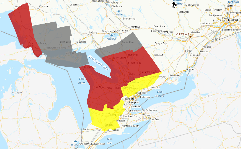
Snow squall warnings (red in the map above) have been issued for several areas, including Barrie, Orillia, Midland, Orangeville, and parts of Dufferin and Grey Counties, among others. These regions can expect the first significant snowsqualls of the season, with potential snowfall ranging from 20 to 35 cm, and localized areas possibly receiving even more. Snowfall rates may range from 5 to 10 cm per hour per hour at times, significantly reducing visibility due to heavy and blowing snow.
A Snow squall watch (yellow in the map above) is also in effect for areas including London, Guelph, Kitchener, and parts of Wellington. These regions should anticipate heavy snowfall tonight through Tuesday, with accumulations of 10 to 30 cm, and intense snowfall rates up to 5 cm per hour.
Toronto, Peel and Halton regions, currently, are not under any advisories, but parts of York, and Durham Regions like Newmarket, Georgina, Northern York Region, Uxbridge, Beaverton and Northern Durham Region are under snow squall watch with an expected total accumulations of 10 to 30 cm.
Roads, highways, and pedestrian paths may become challenging to navigate due to the accumulating snow. Environment Canada suggests postponing non-essential travel until conditions improve.


