There are many ways to go about finding Alberta’s best viewpoints, lookouts, and scenery, but sometimes, all you need to do to find them is pull over from the road!
To Do Canada
There is no doubt that some hikes, boat trips, or paddles can bring you on amazing adventures with equally as great views, but sometimes we don’t have the time or the means to do so.
When this is the case and time or accessibility is top of mind, you can look for some of Alberta’s best views from the side of the road, your car, or a fully serviced rest area with washrooms and picnic tables.
If you’re going through the Rocky Mountains on major routes like the Crowsnest, David Thompson, or the mountain Parkways, then all you need to do is keep your eyes open for the parking lot and rest area signs; many of Eastern Alberta’s coolest viewpoints are found in the Badlands, where you can look out over the hills for hundreds of kilometres.
You may like: 15 Scenic Drives Alberta
25 of the Best Highway Scenic Viewpoints in British Columbia
The Scenic Route to Alaska – Highway AB-40
Jarvis Lake Day Use Area/Kelly’s Bathtub
There are probably hundreds of epic viewpoints to discover within William A. Switzer Provincial Park, but the Jarvis Lake Day Use Area is your best bet if you want to save time, as the parking lot overlooks the south part of the large lake.
Further on down Highway 40, you can also choose to park on the north end of the lake at Kelly’s Bathtub, a beautiful little pond off the lake. Follow short boardwalk trails or enjoy your views from the car!
Up the Forestry Trunk Road
The spectacular views from the Forestry Trunk Road (734) can be enjoyed by the passengers in your car for most of the drive up the hill. There is a place for the driver to enjoy the view from as well, at the first intersection you see.
And what will you see from the hillside road?
Postcard-like scenes of Alberta, with the wide expanses of the mountains and the foothills all in view. The farther you travel up the hill, the more scenery the driver can enjoy on the drive back to Highway 40.
Big Berland Provincial Recreation Area
Enjoy some quiet time next to the Berland River and listen to the sounds of water and wildlife. The turnout after the bridge will bring you to a small picnic and camping area where you can stretch your legs, share a meal, or let your dogs out for a swim.
Grande Cache Lake
When you look to the south of Grande Cache Lake, you’ll see large rolling foothills; and when you look to the south, towering distant Rocky Mountains. On a sunny spring day, the water can appear a bright blue, while the fall months have the lake surrounded by a bright variety of oranges, yellows, and greens.
You may like: Road Trip – Edmonton to Yukon
David Thompson Highway – Highway AB-11
Before the Cline River Bridge
It is important to remember that we can’t stop on the shoulders of this highway, especially on the bridges! But the bridge crossing over the Cline River (which flows into Lake Abraham) is surrounded by gravel access roads which lead to backcountry camping, trailheads, river views, and lake views. Follow the access road on the north side of the bridge to find the some of the best views of Lake Abraham.
Preacher’s Point
A stop at Preacher’s Point will give you a north-facing view of the river valley which leads into the massive Abraham Lake. When the lake’s water levels are low, this area is popular for backcountry campers, and can be a true rest stop off the highway. You may also drive the loop to view the lake’s south shores.
Cline Landing
Take a quick turn down this dirt road to uncover exceptional views of a large portion of Lake Abraham. When water levels are low, you can venture far out onto the sandy areas of the lake shore and view the mountain ranges as they disappear into the foothills. It is a large area with plenty of space for finding your own quiet place to park and enjoy the view or a picnic.
Windy Point
You can use a small access road which takes you around the cliffs which separate Lake Abraham from the Highway. The area will provide views of the lake to the north and the south, and you’ll need your panorama setting to get it all in one photo! If you need an easier-to-access viewpoint, there is a roadside parking lot a few kilometres north of Windy Point.
Icefields Parkway – Highway AB-93
Multiple roadside pullouts provide scenic views along the 227 km long parkway. Here are some of them:
Crowfoot Glacier Viewpoint
Stop on your Icefields Parkway adventure to view all of the Crowfoot Glacier! If you have time, there is space for a picnic with tables and a sheltered picnic area. You can enjoy views of Bow Lake, the glacier, the valley around it, or follow a few short lakeside trails.
Panther & Bridal Veil Falls (aka the Big Bend)
The Parkway’s ‘Big Bend’ has parking lots on either side of the highway’s curve. The beautiful stretch of road offers juts out into the valley incredible views the entire way, but you can get a close-up view of both waterfalls a short walk from the lot on the west side of the large curve in the highway. You can stop at the parking lot on the east side of the bend for even more photo opportunities.
Waterfowl Lakes Viewpoint
The Parkway closely follows the eastern shores of Waterfowl Lakes with a rest stop right up against the water. You will not need to leave you seat to enjoy the beautiful lake and mountain views of the area, but you can venture on a short walk down to the frigid but incredibly clear waters.
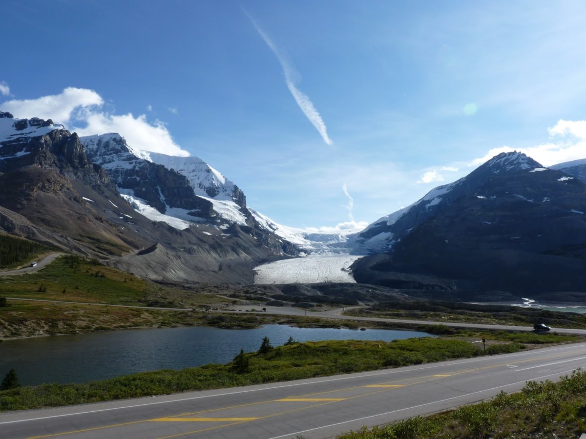
Columbia Icefield
One of the most famous activities along the parkway is the bus trip (Columbia Icefield Glacier Adventure) or a hike to Columbia Icefield. But, if you have difficulty in walking, you can park the car at Columbia Icefield Discovery Centre and see Columbia Icefield from the parking lot.
Tangle Creek Falls
Tangle Creek Falls are so close to the Icefields Parkway, they appear as though they could fall right onto the road. Lucky for us, there is a parking directly across the Parkway from the falls, with washrooms. The parking area allows you to either see the falls from a distance, or up close.
Bow Valley Parkway – Highway AB-1A
Backswamp Viewpoint
While this view does include a look at a large swamp and wetland area, it does offer a whole lot more than that; the Backswamp Viewpoint area looks out over the Bow River and the small mountains/large foothills which surround it. You may also catch a CN train chugging along on the rails below.
Muleshoe Lake Picnic Area
This could be one of the area’s prettiest hidden gems. There will be signage for your turn off from the Bow Valley Parkway, but the area is a lot less populated than some other viewpoints and rest areas and is rich in biodiversity. This could be one of your best rest areas on the Parkway for wildlife viewing!
Morant’s Curve
There are two small parking areas along Morant’s Curve on the Bow Valley Parkway, with one on either side of the road. It is an impressive part of the drive altogether; the Parkway connects Banff and Lake Louise and is mostly through the forest. But once you arrive at Morant’s Curve (heading north), the view opens up and reveals the Bow River Valley, the CP Railway, and a massive forest area which separates Highway 1 with the Parkway.
Crowsnest Highway & Waterton National Park
Crowsnest Lake Boat Launch
As soon as you cross the BC/Alberta border, the Crowsnest Highway passes beside the large Crowsnest Lake. While the lake is awesome for recreation in a beautiful setting, it can also make for a quick yet rewarding roadside rest stop. And to enjoy the view, you don’t even need to leave your car or parking lot. The lot is on the shores of the lake, which is surrounded by foothill forest and low Rockies.
Frank Slide Interpretive Centre
The Crowsnest Highway passes directly through the former town of Frank. The town was tragically destroyed and covered in 1903 from Canada’s deadliest rockslide. You do not need to stop to view the rubble, as it sits up to 45m deep on either side of the road.
Leitch Collieries Provincial Historic Site
The coal industry in the Crowsnest area was booming pre-war, and many of the ruins of the old mines remain. You can visit the fully restored Bellevue Underground Mine for tours and to learn about the life of miners and the history of the industry. But if you’re short on time or are looking for a quick rest stop, the Leitch Collieries offer space to stretch your legs while you wander the abandoned mine structures. The main building was even updated to include a washroom!
Lundbreck Falls
Follow the Crowsnest Pass eastward, and you’ll also follow the Crowsnest River. The river takes a dramatic and rocky plunge where you can easily access the Provincial Recreation Area. The rest stop is a convenient place for beautiful waterfall views, peaceful picnic scenery, or for a quick walk/break from the car.
Waterton Lookout
Catch this spectacular view on your way into Waterton National Park! The area, known as “where the mountains meet the prairie,” is a sweeping view of the park as a whole, with lush foothills in the foreground and the Rockies/ Belly River Valley in the distance (6 tall peaks to be exact).
Maskinonge Overlook
You are awarded 360-degree views from this lookout before entering Waterton Lakes National Park- views which show off Alberta’s most iconic scenery. That iconic scenery includes mountains, lakes, wetlands, foothills, and prairies. Learn about the area through the interpretive signs, explore the short trail, or sit back in the car and enjoy the view.
Alberta Badlands
Dry Island Buffalo Jump Provincial Park
The Dry Island Buffalo Jump viewpoint is the beginning of the Alberta badlands, where the hills are far greener and lusher than some other areas. The badlands formations still appear in some spots above the greenery, and the trails offer views of unique rock formations or wildflowers and cacti.
Horsethief Canyon
This roadside stop is on the North Dinosaur Trail and allows you an almost birds-eye-view of the canyon. The badlands show off all their colourful layers, the grassy fields at the bottom, and distinctly show signs of being a former riverbed. You can stare out and imagine all of the canyon filled with water- when actual dinosaurs roamed the Dinosaur Trail.
Orkney Viewpoint
You’ll feel as though you can see all of the Alberta badlands at once from the Orkney Viewpoint, off the south Dinosaur Trail. The east-facing view is on the opposite side of the Red Deer River as the Horsethief Canyon Lookout; you could easily see both in a day or take the Bleriot Ferry and do it all by bike.
Horseshoe Canyon
Kneehill County has many beautiful sites to behold, and Horseshoe Canyon is one of the more tucked away views. While you drive along Highway 9, you are surrounded by flat prairies. But take a short drive off the highway to view a deep section of badlands that date back to the Cretaceous period. The rest area has amenities likes washrooms and trails, and you can see the entire canyon from the viewing area/parking lot.
https://www.instagram.com/p/CfSyPKrLljk/?utm_source=ig_web_copy_link


